Ports and small yacht harbours
JELSA (43° 10’N; 16° 42’E), town (pop. 1,792 in 1991) and small harbour on the N coast of the island of Hvar.
Approach: The town is easily identified from some distance by the prominent buildings of the hotel complexes flanking the harbour entrance, the road leading to the cemetery with a bell tower on the E side of the entrance, the red round iron tower exhibiting a red light on the breakwater fronting the cemetery and the eight- sided masonry tower with a cupola exhibiting a green light situated on the head of the N breakwater.
Mooring: The inner harbour affords shelter from all winds, only its S part does not provide sufficient shelter during a strong bora. The outer part of the harbour is completely exposed to northerlies and to the bora and a dangerous surge develops in it with such winds. Only small yachts can moor using the four-point moor, at the quay (depth 1.63.4m alongside). The inner harbour is occupied by local craft. Passenger liners land at the S mole. An anchorage ground is situated 250m NE of the breakwater (depth around 12 m), but it is not recommended to use it in the winter months during the bora.
Facilities: Harbour master’s branch office, post office, medical service, and chemist’s. Pic Fishing Club. Zecevo naturist hotel complex is situated N of the town, behind Glavica point.
Provisions at local shops (self-service store). Water from hydrants on the waterfront. Fuel at the petrol station (about 300m from the waterfront).
A small slipway is situated in the S part of the harbour.
Each year at the end of August the Jelsanska festa vina (Jelsa Wine Festival).
Sights: Sv Fabijan i Sebastijan church (St Fabian and Sebastian, 1331; renovated and fortified in 1535), Sv Ivan church (St John, in Baroque style); the square with Renaissance and baroque houses. Cemetery at the locality called Gradina with a church of the Augustinians (16/17 C) and remains of an old defence wall (11/12 C). On Tor hill an ancient Greek watch-tower (4 C B.C.).
POKRIVENIK (43° 09’N; 16° 53’E), cove in the middle of the N coast of the island of Hvar.
Approach: It is entered between Tanki point and Zarace point, which are foul and should be given a berth of at least 300 m.
Mooring: The inlet is sheltered from all winds except norther- liess and the bora. Shelter from the bora, to some extent, can be found in its SE part. Smaller yachts can berth alongside the pier on the E coast of the cove. The best anchorage is in its SE part.
SUCURAJ (43° 07.5’N; 17° 11.5’E), village (pop. 422 in 1991) and small harbour in the inlet of the same name at the easternmost end of the island of Hvar.
Approach: Landmarks include the square stone tower with a balcony beside a dwelling exhibiting a white light on Sucuraj point; the red round iron tower exhibiting a white light on the head of the breakwater, the low white building with a green factory chimney on the N coast of the inlet in front of the village.
Care should be taken to avoid the underwater ballasting of the breakwater with shallow water over it and a submerged block off the SE side of the small pier.
Mooring: E and SE winds raise a heavy sea inside the harbour. Continuous northerly winds cause the depth in the harbour to decrease, which should be taken into account. Smaller yachts can berth at the ferry-pier using the four-point moor, or sidelong at the inner side of the breakwater. They can also lie sidelong and using the four-point moor at the quay in front of the harbour master’s branch office (depths 23.5 m).
Facilities: Harbour master’s branch office, post office, medical service, fish-cannery. Pagar Fishing Club.
Food provisions and water.
Car-ferry line: Sucuraj Drvenik (Makarska Riviera).
Sights: Parts of an Augustinian monastery (1573, now housing per- sonage), Sv Ante church (St Anthony, 1664), and the pictoresque small square in front of it. Fortifications dating from 1631.
MRTINOVIK (43° 07’N; 17° 06’E), cove in the S coast of Hvar, about 4.4M W of Sucuraj point. The cove is protected from all winds except those blowing from the SE and SW quadrants, which are apt to raise a moderate sea in it. The anchorage ground is in the middle of the cove.
Facilities: In Sucuraj.
ZAVALA, also Pitavska plaza (43° 07.5’N; 16° 42’E), village (pop. 110 in 1991) and small harbour on the S coast of Hvar, opposite the island of Scedro.
Mooring: The small harbour is sheltered from all winds except south-westerlies. Smaller yachts can lie along the inner side of the breakwater (depths 26 m). Anchorage with sandy bottom (depths 34 m).
Facilities: Provisions at a local shop; a restaurant; water from cisterns.
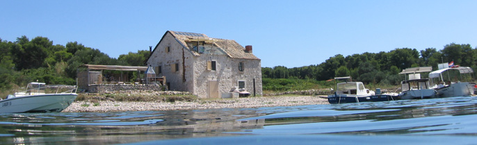
MILNA (43° 09.5’N; 16° 29’E), inlet in the S coast of Hvar.
Mooring: The cove provides good shelter from N winds to smaller yachts. Depth up to 2 m.
Warning: Rocky shoal patches extend off the NW point.
Sights: Sv Marija Magdalena chapel (St Mary Magdalene, transitional Gothic-Renaissance style, 15 C); partly fortified summer-residence of the Ivanic and Boglic-Bozic families (17 C) with chapel.
HVAR (43° 10.5’N; 16° 27’E), town (pop. 3,643 in 1991), tourist resort and harbour on the S coast of the island of the same name.
Approach: Landmarks: the stone tower mounted on a pedestal exhi- biting a white light on Pelegrin point, the square stone tower above a dwelling exhibiting a white light situated on the islet of Pokonji dol, the red iron tower with a column exhibiting a red light on the NE edge of Jerolim islet, the forts Spanjol and Sveti Nikola, the television mast W of the city, Galisnik islet with a square stone tower exhibiting a green light on its S side.
Anchorage is prohibited in the passage between Galisnik islet and Krizni Rat point.
Mooring: The Hvar harbour is exposed to north-westerlies. South- erlies, especially the sirocco, raise waves and an unpleasant swell inside the harbour. The S part of the wharf is used by yachts on regular services. Yachts drawing up to 2.5m can lie at the waterfront W of the small harbour Mandrac using four-point moor. Larger yachts anchor N and NW of Galisnik islet (depths 2025 m). Smaller yachts can anchor in the middle of the harbour (depths 810 m) securing their sterns to bollards on the W shore. Yachts can also sail into Palmizana Marina on the islet of Sv Klement (Pakleni otoci).
Facilities: Harbour master’s branch office, post office, medical service, chemist’s. Pelegrin Fishing Club. Zvir Yacht Club.
Naturist beach on the islet of Jerolim S of the harbour.
Fresh food provisions at the shops and the self-service store. Water laid on to the NE waterfront (hydrant). Fuel obtainable from the pump on the pier in the E harbour Krizna Luka. Minor repairs can be arranged; slipway (width 5 m).
Sights: Town walls (built after 1278, additions in the 15 C). The Palace Hotel (1903) occupies the site of the demolished Rector’s Palace; the Clock Tower (Leroj, 1466, reconstructed); Spanjol (elevation 109 m, built 1551) and Sv Nikola forts (formerly: Fort Napoleon, built 1806, elevation 241 m); harbour (port development since 1455, the Venetian fleet of the Eastern Adriatic used to winter here); the Arsenal (15791611) into which galleys could be hauled up and the adjoining Fontik (housing historical archives, a Gallery of Modern Painting, the wooden figurehead of a dragon from the galley sent by Hvar to the Battle of Lepanto, 1571). Above the Arsenal a Theatre (built 1612, one of the oldest in Europe still extant, renovated in 1803 and 1900); Sv Stjepan cathedral (St Stephen, built in the 1617 C on the site of an ear- lier cathedral dating from 14 C, liturgical objects dating from the 1517 C, Gothic-Renaissance choir-stalls treasury) with the campanile from the 17 C. On the main square: the town well (1529); the residential homes of the families Paladini, Hek- torovic (unfinished, 15 C), Grguric, Lucic, Vukasinovic; the sum- mer residence of the dramatist Hanibal Lucic; the City Loggia (by Tripun Bokanic, early 17 C); Sv Marko church (St Mark, preserved side walls and belfry from 1550, lapidarium; the tower of St Ven- erando on the extremity of the headland (now an open-air the- tare); the Franciscan monastery (146164) in the SE part of the town (Renaissance cloister and refectory, collection of paint- ings, illuminated manuscripts, naval charts, old embroidery, archives, library), with Gospa od milosti church (Our Lady of Mercy, 1465, reconstructed 1571, three polyptychs, carved choir- stalls, paintings by Italian masters).
VELA GARSKA (43° 11’N; 16° 25’E), cove on the S coast of the westernmost part of Hvar, in the channel Pakleni kanal, about 1.6M west of the town of Hvar.
Approach: The mouth of the cave on the W entrance point is con- spicuous.
Yachts entering the cove should keep closer to the E coast.
Mooring: The small bay indented with several inlets affords good shelter, especially from winds blowing from the NE and SE qua- drants. The sirocco blows violently but raises only a moderate sea. Yachts can moor at the small pier (depth up to 2 m) in the W part of the bay. Four-point moor with bows facing seaward recom- mended.
Facilities: In the town of Hvar.
PAKLINSKI (PAKLENI) OTOCI
PALMIZANA (49° 09.5’N; 16° 24’E), cove in the N coast of the islet Sv Klement, about 2M west of the town of Hvar.
Approach: When approaching the cove, care should be taken to avoid Baba rock (rising about 1m above sea level; white flashing light) in front of the entrance to the cove.
Mooring: The cove affords good all-round shelter from all winds and the sea. Good anchorage grounds under the E shore and off the SW coast, where lines should be secured to the rocks of the shore. Depths 615 m. The pier in the SW part of the inlet is reserved for tourist lines.
Facilities: In Palmizana Marina and Hvar.
PALMIZANA MARINA (ACY) is situated in Palmizana cove on the N coast of the island of Sv Klement, the largest in the island group of Paklinski (Pakleni) otoci.
Capacity: about 190 berths at pontoons extending parallel with the N shore and at the floating fingers at the W shore. The depth along the W shore are around 2 m, along the N shore 7 m, and in the middle of the cove between 1220 m.
The marina operates through the summer season.
It has reception office, restaurant, shopping area including duty-free shop, toilets and showers with hot water, rental of sports equipment; sale of butane gas; workshop for maintenance and repair jobs; taxi yacht.
SOLINE (43° 09.5’N; 16° 22’E), spacious cove in the S coast of Sv Klement island.
Mooring: S and SW winds raise a heavy sea inside the cove. An anchorage ground for yachts of deeper draught is situated NE of the Dobri islet (depth 32 m). Only temporary stays recommended.
Facilities: Limited supplies at Vlaka hamlet (about 400m inland).
ISLAND OF SCEDRO
LOVISCE (43° 06’N; 16° 42.5’E), village (pop. 9 in 1991) and cove on the N side of the island of Scedro.
Approach: The red iron tower exhibiting a red light E of the cove entrance is conspicuous.
Mooring: The cove affords good shelter from all winds except northerlies, which may blow with violence and send in a swell. During such winds smaller yachts seek shelter in one of the three small coves (Rake, Srida or Lovisce) securing their lines to the bollards or to rocks on the shore. A good anchorage ground for larger yachts is situated in the middle of the cove (depth about 26 m).
MANASTIR, also Mostir (43° 05.5’N; 16° 42.6’E), cove in the N coast of Scedro, E of Lovisce.
Like Lovisce it is open to northerlies but it affords good shelter from S wind and the waves. Only yachts of very light draught can berth at the small pier at the head of the cove using the four-point moor. The depth at the pier head is only 1 m.
Sights: Ruins of Dominican monastery (16 C, deserted in 18 C, later incorporated into a Renaissance church).
ISLAND OF BISEVO
BISEVSKA LUKA (42° 59’N; 16° 00′ E), cove in the W coast of Bisevo. Suitable only as a temporary refuge from the bora. When other winds start blowing, especially westerlies or south- westerlies, yachts should leave without delay. It provides no adequate shelter from the sirocco either, since this wind is apt to change its direction to the SW in these parts. Yachts of light and medium draught can anchor in the inner part of the cove (depths 510 m).
Polje hamlet (pop. 14 in 1991) inland.
BALUN (42° 58.5’N; 16° 01’E), cove in the E coast of the island of Bisevo. The famous Blue Cave (Modra spilja) is situated in this cove. At noon, when the sea is calm, sunrays penetrating into the cave through an underwater opening are reflected from the white bottom, and illuminate the cave with a blue light while lending a silvery hue to objects under the water. The cave can be entered by small yachts only.
ISLAND OF VIS
VIS (43° 04’N; 16° 11’E), town (pop. 1,932 in 1991) and harbour on the N coast of the island of the same name.
Approach: Landmarks: the lighthouse Stoncica, a masonry tower on a dwelling exhibiting a white light, situated on the cape bearing the same name; the concrete tower with a balcony exhibiting a red light on Krava rock (E of the entrance); the eight-sided masonry tower exhibiting a white light on Host Islet; the white tower with a balcony on Volici rock; the ruined Fort Wellington on an elevation on the left side of the entrance and Fort Torjan on its right side; the white tower exhibiting a red light on the head of the car-ferry landing place.
Care should be taken when making an approach to avoid the rocks Krava and Volici and the islet of Host.
Mooring: The harbour is open to the bora, which blows here with violence and raises a considerable sea. The sirocco also blows with heavy gusts. Protracted southerlies are apt to raise the sea level inside the harbour considerably. The E shore of the bay is exposed to waves coming in from the NW. Yachts can moor in the SW part of the harbour (depths 34 m). Yachts drawing up to 2m can berth along the shore in Kut Cove (to the SE). Deeper drawing yachts can also anchor in Kut Cove except during northerlies and north-westerlies. During the bora and the sirocco it is recom- mended to anchor W of the small Pirovo peninsula.
Anchorage is prohibited in the W part of the harbour due to an underwater sewer pipeline. The pipe extends for 300m from the shore, E of the Issa hotel.
Facilities: Harbour master’s branch office, post office, medical service, chemist’s.
Provisions at local shops and at self-service shop. Water in lim- ited supply. Fuel at the pump on the small pier in the NW part of the harbour. Host Fishing Club.
Car-ferry line: Vis Split.
Sights: In the Gradina area remnants of the ancient Greek town of Issa (walls, seawall, numerous finds); remnants of Roman walls, thermal baths and mosaics from the 1 C; on the small Pirovo pro- montory remains of a Roman theatre and thermal baths (a Francis- can monastery with a church was built on the site in the 16 C). In the town of Vis the Garibaldi Palace (1552); the summer- residence of the poet Marin Gazarovic (early 17 C); the house of the Dojmi-Delupis family (with a collection of archeological finds from antiquity); four defence towers on the outskirts of the town (17 C); Gospa od Spilice church (Church of Our Lady, about 1500); Sv Ciprijan church (St Cyprian, 1 C, renovated 1742, coffered ceiling); Sv Duh (Holy Spirit, early 17 C); the British forts: George, Wellington, Bentinck, Robertson (early 19 C). Old Austrian barracks Baterija housing the Archaelogical Museum (Arheoloski muzej). A number of monuments commemorating events from the Anti-Fascist War (1941-45).
During the Anti-Fascist War, from 194344, Vis was the main base of the naval forces of the National Liberation Army, and from June 8 to mid-September 1944 seat of the Supreme Command and the Committee of the Liberation of Yugoslavia headed by Marshal Tito. Vis served as the base for the seaborne assault operations that ultimately led to the liberation of Dalmatia.
ZBODY 1.5 KRAJ = KOMIZA (43° 03′; 16° 05’E), town (pop. 2,032 in 1991), harbour and spacious bay on the W coast of the island of Vis.
Approach: The harbour is easily recognised from seaward by the white masonry tower exhibiting a white light on the small islet of Barjak Mali; Sv Nikola church (St Nicholas) SE of the town (elevation 57 m); by the square masonry tower exhibiting a white light on Stupisce point; the red tower with a balcony exhibiting a red light on the island of Bisevo (Kobila point); the green metal fremework tower with a column and a balcony exhibiting a green light on the head of the breakwater.
Mooring: The bay is exposed to westerlies and south-westerlies, which raise a heavy sea. Behind the breakwater (depths 35 m) yachts are protected from these winds, as well as from the bora and the sirocco. Yachts can moor at its inner side, but it should be borne in mind that the area around its head is reserved for regular passenger lines. Smaller yachts can berth at the quay NE of the breakwater using the four-point moor. A good anchorage ground (depth around 30 m) is situated 500m W and 850m S of the harbour light, but a bora renders it untenable.
Facilities: Harbour master’s branch office, post office, medical service, chemist’s, Neptun fish-cannery with its own fleet.
PLOCE (43° 03’N; 17° 25.6’E) town (pop. 6,336 in 1991) and com- mercial port NW of the delta of the Neretva river.
Approach: Landmarks: the red tower with a column and a balcony (white light) on the S extremity of Visnjica headland (Rt Visnjica); the red light-buoy topped by a red cylinder on top exhibiting a red light marking Gumanac shoal about 0.8 M south of the light on Visnjica headland; the green light-buoy (green light) about 0.3 M south of the light on Visnjica headland; the green light-buoy (green light) about 300 m east of the light on Visnjica headland; the red tower with a column and a balcony (red light) about 300 m north of the light on Visnjica headland; the red square tower with a pyramidal construction (red light) on Bad point; Gubavac islet in the small cove between Bad point and the red tower situated about 300 m north of G. Visnjica headland (Rt G. Visnjica); the green tower with a column and a balcony exhi- biting a green light on the westernmost part of the wharf (Gat Oslobo|enja).
The port is entered through a marked approach channel, the tower on Visnjica headland (white light) marking its beginning; two green light-buoys (green light) on the NW end of the wharf mark its right side; the red light-buoy on the Gumanac shoal marks the beginning of Vlaska channel, which leads to the tanker terminal.
In times of heavy rainfall, S winds and strong currents, yachts should keep as close to the buoys as possible.
Mooring: The harbour affords good protection from all winds and waves, although the bora and the sirocco are strongly felt, par- ticularly in the winter. In summer the prevalent wind is a north-westerly, which blows here with greater force than in the Neretva channel and lasts till late in the evening. Attention should be paid to the direction in and at the rate at which the current is setting in the harbour approaches, particularly in the vicinity of Visnjica headland. Yachts moor according to instruc- tions received from the harbour master’s office, i.e. either in the city port which encompasses the Mala posta bay (the E arm) and the area S of the connecting line defined by the following points on the coast: 395 m off the green light on Gat Oslobo|enja on a bearing of 335° and 870 m off the same light on a bearing of 22°.
Yachts are forbidden from entering the N part of the bay, outside the limits of the commercial port unless previous permission has been obtained from harbour master’s office.
The port is open to international traffic as a permanent port of entry.
Facilities: It has a duty-free zone (marked by white buoys in the form of double cones), harbour master’s office, customs house, post office, medical service, chemist’s, bus station and railway station. Lica Fishing Club and Mornar Yacht Club.
Provisions at local shops, water from the hydrants on the water- front. Fuel at the pump on the waterfront. Naval charts and other relevant publications may be obtained at the office Svetionicarska stanica, Ploce, Neretvanskih gusara 1.
Repairs to yacht and yacht hulls as well as repairs and mainte- nance of marine engines are possible.
Car-ferry line: Ploce Trpanj.
NERETVA, river flowing into the Neretva channel; navigable for yachts drawing up to 4.5 m (mastheads up to 14 m) from the river mouth to the bridge in the town of Metkovic.
In the Neretva valley the bora blows with violence, particularly in the area around Kula Norinska village. In summer in the morn- ing hours there is usually a breeze blowing seaward, down the valley and in the afternoon a wind blowing in from the sea. Under settled weather conditions the current is not strongly felt (about 2.5 knots) but it can attain a rate of 6 knots when the river is carrying a great amount of water.
Approach: Landmarks: the hexagonal red cement hut with a column exhibiting a red light on the head of the N mole at the river mouth, the green square hut with a column exhibiting a green light on the head of the S mole, the guardian’s house on the S embankment and the cross on Galicnik Hill.
In the river mouth: the red light-buoy Gumanac topped by a cylinder (about 0.8 M south of the light on Visnjica cape head- land); the green cylindrical light-buoy topped by a cone (785 m from the red light on the head of the N protective mole on a bearing of 294° from the red light on the head of the N protec- tive mole); about 100 m from the red light on the head of the N mole, at a bearing of 240°, there is a green cylindrical buoy with a conical topmark, which should be left to starboard by incoming yachts (see Ploce).
The river mouth is entered S of the red Gumanac buoy. After clearing the light-buoy yachts should shape course north of the green light-buoy (small yachts as close to it as possible). When abreast the buoy, course should be altered so as to lead between the N molehead (red column on hut, red light) and the green cylindrical buoy topped with a cone. After passing the N molehead (red light) yachts should take a sharp turn towards the middle of the river mouth, between the N and S protective moles (green hut with column, green light).
Warning: Due to banks formed by deposits in the river mouth, it is advisable to keep in dredged channel. It is necesarry to start changing course between the two moleheads (with lights on them) on time as the current at the river entrance is stronger. Yachts are recommended to reduce speed before changing course (when abreast the green buoy topped by a pyramid). About 4 km upstream the Gospa shoal extends off the right bank. Another shoal is situated at the E end of the quay in Opuzen (near the spot at which Mala Neretva branches off). The NW edge of this shoal is marked by a black buoy, which should be left to starboard by yachts proceeding upstream. A road bridge of the Adriatic highway crosses the river at Rogotin village (pop. 727 in 1991), about 4 km upstream from the mouth (at highest water level the bridge has a vertical clearence of 14 m in the middle, reducing to 11 m at the piers). A high-tension cable with a vertical clearance of 15 m at highest water level spans the river 9.2 km upstream from the mouth, near the small town of Komin (pop. 1,546 in 1991).
Care should be taken to avoid collision with the numerous local craft (trupice), passing up and down the river or entering it from the side arms. Special Regulations for Navigation in the Neretva River. Yachts may navigate in the Neretva any time of the day or night. Yachts must keep to the starboard side. Navigation in fog is prohibited. Yachts proceeding downstream must have an anchor ready for instant use astern. At night, anchoring yachts are required to display an additional white position light astern, as well as the white position light on the bow prescribed by the International Regulations for Prevention of Collision at Sea. Yachts passing other navigating or floating objects, installations on the river banks, places at which hydrotechnical operations are in progress, or inhabited places are required to reduce speed at least within 200 m of such objects, installations and places so as not to endanger their safety or cause demage. Yachts proceeding upstream (with the exception of towing tugs) must give way to yachts navigating downstream. Yachts must give way to ships. A yacht which loses its manoeuvering capacity is required to drop anchor at a place where it will not obstruct other yachts. Moored yachts and yachts at anchor are forbidden to keep dinghies, rafts, etc. or any other protruding objects secured alongside.
OPUZEN (43° 01’N; 17° 34’E), town (pop. 2,778 in 1991) and har- bour on the left bank of Neretva, about 6.5 km upstream from its mouth.
Approach: The green tower on a pedestal on the W bank (down- stream) is conspicuous.
Mooring: Yachts can berth at the town quay (depths 2.42.9 m). A shoal patch with depth up to 4.5 m over it is situated at the NW end of the harbour. It is marked by a black conical buoy.
All yachts are prohibited from navigating, anchoring and landing at the section between the point at which Mala Neretva bifurcates and the iron bridge crossing it higher upstream when the water level rises 1 m above normal.
Facilities: Post office and medical service; the Neretva agricul- tural enterprise has citrus fruit and vegetable farms in the vicinity.
Food and water in adequate supply. Fuel at the pump about 20 m from the river bank.
Sights: Fort Kos (late 15 C), renamed by the Venetians in 1685 to Fort Opus in ruins on a hill above the town; a collection of archaeological finds from Vid village, which occupies the site of Roman Narona; monument to the national hero Stjepan Filipovic. On a hill above the nearby village of Podgradina the ruins of Brstanik castle built in 1373, during the reign of the Bosnian King Tvrtko (restored in 15 C and in 1878). Up to Neretva (on its left bank) Kula Norinska with a cylindrical defence tower (1550).
METKOVIC (43° 03’N; 17° 39’E), town (pop. 12,026 in 1991) and principal harbour on the Neretva, situated about 11 M upstream from its mouth.
Approach: Landmarks: two red towers exhibiting red light are situated downstream from the bridge: one 1.1 M (Jerkovac), the other 0.4 M.
Mooring: Yachts can berth at the lower part of the S bank, at the quay fronting the harbour office (downstream from the harbour light). Attention should be paid to the underwater reinforcements of the quay, which extend at places up to 0.7 m offshore. The N quay is reserved for commercial operations.
Warning: Yachts are forbidden to land at certain portions of the quay.
Metkovic is a permanent port of entry.
Facilities: Harbour master’s branch office, post office, hospi- tal, chemist’s and railway station (regular line to Sarajevo).
Food supplies at local shops. Water from the water main (taps on the quay), fuel (diesel oil) on the N bank, 25 m downstream from the bridge. Mehanika undertake repairs to and maintenance of marine engines.
Sights: Vid (village on the site of ancient Roman Narona) with numerous archaeological finds (remnants of town walls, stone fragments bearing inscriptions, mosaics, graves, Roman fragments built into the walls of village houses; Museum collection) 4 km by road to the NW; Mogorjelo (restored Roman villa rustica from the early 4 C with remnants of two early Christian basilicas and ancient farm buildings) 14 km by road to the NE; Pocitelj (16 C), medieval castle, reconstructed into a Turkish residence around which a settlement developed: defence walls with towers, a mosque, a clock-tower, Muslim religious school, the residence of the Pocitelj captains, Turkish inn and bath.
Artists’ colony, every first Sunday in June Tresnjeva nedjelja (Cherry-picking Festival) 19 km to the north.
Ornithological collection one of the most comprehensive in Europe (more than 300 stuffed specimens of birds and game) represents the endemic and migratory wild life of the Neretva delta.
DUBA PELJESKA (43° 01’N; 17° 10’E), village (pop. 67 in 1991) and small harbour on the N coast of Peljesac Peninsula, about 4.5 M west of the harbour of Trpanj.
Mooring: The small harbour affords protection for small yachts from the bora and the sirocco. It is open to waves raised by north-westerlies.
Yachts are recommended to moor at the inner end of the breakwater (depth 23.5 m).
Facilities: Provisions and water are limited.
Sights: Remains of a Roman building with mosaics. The summer residence of the poet Dinko Ranjina (15361607) from Dubrovnik was in nearby Divna cove (1 mile E).
TRPANJ (43° 00.5’N; 17° 16’E), village (pop. 660 in 1991) and small harbour on the N coast of Peljesac Peninsula in the Neretva channel.
Approach: Landmarks: two chapels on two cone-shaped hillocks; a red tower exhibits a red light on the head of the E breakwater; a white column exhibits a red light on the head of the pier.
Care should be taken while approaching the harbour to avoid a shoal patch with depth of about 3.5 m over it, about 0.4 miles WNW from the head of the N breakwater. Shallow water extends off the outer end of the S breakwater, which should be given a berth.
Mooring: The harbour is protected from winds from the NE and SE quadrant. Northerlies and winds from the NW quadrant raise a heavy sea in the E part of the harbour. Yachts can moor along the quay or W of the pier (depths 13 m) using the four-point moor. The four-point moor with bows facing the second arm of the north, L-shaped breakwater is also recommended. This position affords protection from westerlies and from waves.
Facilities: Harbour master’s branch office, post-office, medical service and a chemist’s. Gruj Fishing Club.
Provisions at local shops. Water from the hydrant on the pier. Fuel at the pump on the waterfront.
Car-ferry line: Trpanj Ploce.
Trpanjske glazbene veceri (Trpanj Music Evenings) are held here in July.
Sights: Remnants of a Roman summer residence (villa rustica) at the cemetery; near the ruins of a medieval castle a Roman pis- cina; the Baroque church Gospa od Karmela (Our Lady of Carmel); a private art collection in the house of the Salacan family.
DRACE (42° 56’N; 17° 27.4’E), village (pop. 48 in 1991) and small harbour in Bratkovica cove on the N coast of Peljesac Peninsula. It serves as the harbour of the village of Janjina (pop. 371 in 1991) situated about 3 km inland.
Approach: The stone mark on Bililo shoal with a topmark (two cones turned base to base) and the white tower with a column (sector light) on the head of the N breakwater are discernible from a distance. Care should be taken when making an approach to avoid the numerous rocks and shoals E of Rat point and around the islet of Galicak. The red sector of the light on the N breakwater covers the clear passage to the harbour.
Mooring: Behind the breakwater yachts are protected from all winds. Smaller yachts can moor inside the harbour (depths 1.33). The anchorage ground ENE of the harbour becomes untenable in a bora.
Facilities: Post office and medical service. Batas Fishing Club.
Provisions and water in limited supply.
BRIJESTA (42° 54.2’N; 17° 32’E), village (pop. 130 in 1991) in the cove of the same name on the N side of the Peljesac Penin- sula.
Approach: Brijesta may be identified by the white tower with a balcony exhibiting a white light on Blaca point and by the old tower and the belfry at the head of the cove.
Mooring: The cove is protected (partly by a string of islets) from all winds and affords good shelter to yachts of all sizes. A good anchorage ground for larger yachts is situated about 700 m SSE from Blaca point (depths 1723 m). Smaller yachts can anchor in the inner part of the cove. During the bora yachts at anchor are well advised to secure their lines on the NE shore.
Provisions and water in limited supply.
Sights: Defence tower built 1617 for protection against pirates; Baroque chapel of Sv Liberan (St Liberanus) at the cemetery.
KUTA (42° 50’N; 17° 45’E), cove at the head of Mali Ston bay, between the Adriatic highway and the Peljesac road.
Approach: Yachts aproaching from the NW ahould take care to avoid the shoal (with a depth of 3 m over it) situated in the straits between Govanj islet (recognizable by a few buildings scattered in a sparse forest), also known as the island of Life (Otok Zivota) in tourist literature, and the village of Hodilje. The cove is fronted by a string of islets (Crkvica, Veliki Skolj and Bisaci). Between them the sea is shallow. A dark rock is visible SW of Crkvice islet, and W of Veliki Skolj there is a low-lying rock seen only when closely approached.
Mooring: The anchorage ground (depth 68 m) off the NE shore affords shelter from all winds.
ZALJEV MALOG STONA, bay situated between the mainland coast and the Peljesac Peninsula, is a continuation of the Mali Ston chan- nel. In some places it is narrow and shallow. Between the small harbour of Hodilje and Mali Ston there are a number of submerged rocks. Only yachts drawing up to 3 m can navigate from the islet of Govanj to Kuta cove. A bridge spans the entrance to Bistrina Cove.
From Celjen point (white tower with a column and a balcony exhi- biting a white light) course should be shaped towards the middle of the entrance into the narrow part of the bay. At night course should be shaped towards the middle of the line connecting the green light (white tower) on the molehead at Hodilje and the red light (red tower) marking Vranjak shoal. North of the harbour light at Hodilje, yachts should gradually change course so as to leave Vranjak to port and proceed closer to the islet of Ostrog in such a way that the green light (green tower on a cement base in the sea) marking the Skoljic shoal (1.4 m) is left to star- board and the red light (red tower) on Mali Voz point to port. Oyster beds are marked with marker buoys. An underwater cable is laid between the islet of Govanj (sparsely wooded) and Peljesac Peninsula.
The bora blows violently, especially in the winter season. In the summer months the area is subject to frequent storms. Sudden changes in the water level, the so-called ses (1 to 2 m) which may occur when S winds suddenly start blowing but occasionally also in calm weather and during storms, are accompanied with strong and changing currents (whirlpools and fierce eddies). This phenomenon is rather rare, but when it occurs it is dangerous.
Shelters: Mali Ston, Kuta cove (depths 68 m at the anchorage ground), but care should be taken to avoid the islets, rocks, shoals and rocky patches. Misevac cove (S of the islet of Skrpun) has a good anchorage ground for small yachts.
An underwater pipeline is laid on the sea-bed between the main- land and the shore of the Peljesac Peninsula (100 m NW of Celjen point).
MALI STON (42° 51’N; 17° 42’E), village (pop. 152 in 1991) and small harbour on the NE side of the Ston isthmus, in an indented inlet in the Mali Ston Channel.
Approach: Landmarks: old fortifications (5 towers) above the vil- lage and on the slopes of Mt Bartolomija. A white tower with a column and a balcony exhibiting a white light on Celjen point.
Mooring: The harbour is sometimes subject to sudden change in the water-level (ses); the sea level falls suddenly and immediately starts to rise again, at times even to 2 m above normal. Only smaller yachts can enter harbour through the passage between Govanj islet and the village of Hodilje (depth of about 3 m), as the depth inside the harbour ranges from 0.7 to 2.4 m. The har- bour provides shelter from all winds.
Facilities: Provisions at local shops, water from the main; fuel at Zamaslina on the Adriatic highway (4 km by road).
Oyster beds in Bistrina cove in the Mali Ston Channel; hotel com- plex on nearby Govanj islet (Otok zivota).
Sights: Town walls (133658) with Sea Gate; Fort Koruna (with 5 towers) above the village; the cylindrical Toljevac tower (1478) on the quay. The medieval defence system of Mali Ston is linked with that of the town of Ston (long walls transversing the isthmus and linking both towns with the fortress on Pozvizd sum- mit (elevation 224 m).
STON or VELIKI STON (41° 49.5’N; 17° 42’E), village (pop. 581 in 1991) and small harbour in the NW part of Ston Channel (Stonski kanal).
Approach: Landmarks: the ruined medieval defence walls above the town; a round red tower with a column exhibiting a red light is situated on the quay at Ston.
ZBODY 0 KRAJ = Due to a submerged stone block at the beginning of the fairway, about 80 m NNW of the light on the molehead at Broce, yachts should keep closer to this light. The fairway lead- ing to Ston is marked on the right side by two towers (green light) mounted on concrete bases in the sea. The left side of the fair-way is marked by 4 towers (red light) on concrete bases in the sea and by a red tower (red light) in the small harbour of Broce. From the light on the molehead (Broce), yachts should proceed between the first pair of the lights on concrete bases, then closer to the red tower on a concrete base in the sea (about 1030 m on a bearing of 299° from the light on the molehead at Broce); then S of the line connecting the red light with the red light of the second pair of lights On account of the shallow sea (up to 1.5 m) yachts should keep close to the middle of the chan- nel and then pass between the second pair of lights After pass- ing it, they should shape course for the molehead at Ston, on which there is a red tower (red light). An incoming yacht must wait in front of Broce for any yacht navigating through the fairway. A yacht wishing to leave Ston must wait for any yacht coming through the fairway to reach Ston harbour.
Mooring: The harbour is protected from all winds and waves. Tides may cause a strong current which can make manoeuvering difficult. Yachts lie sidelong the mole or at the quay. The four-point moor may also be used. An anchorage ground is situated in the outer part of the inlet, SE of Broce (depths 1050 m). Good holding ground.
Facilities: Harbour master’s branch office, post office and medi- cal service. Provisions in local shops; water from the main; fuel at the petrol station in the village. Liganj Fishing Club.
Sights: City walls (890 m in length) in the form of a pentagon encompass the old town, the streets of which intersect at right angles. From the town walls the 5 km long Veliki Zid wall extends (13331508), which runs up to the Pozvizd summit (224 m), whence it links with the defence walls of Mali Ston. Remnants of the castle (Veliki Kastel), the Rector’s seat in the time of the Dubrovnik Republic; the Sorkocevic- 8r|evic residence (Gothic); the former bishop’s residence (1573, with Gothic windows); a Francis- can monastery and Sv Nikola church (St Nicholas, 1347, old liturgical objects), town well (1571), Sv Vlaho church (St Blaise, 1878, with items from an older church). On Gorica hill above Ston Sv Mihajlo chapel (St Michael, 9/11 C, mural paintings from that period). Solila (salt pans), were in use even before the Dubrovnik Republic gained possession of Peljesac Peninsula (1333). They occupy an area of over 429860 m2 and have an annual output of 2800 tons of salt.
STONSKI KANAL, deep and narrow channel leading from the Kolocep channel (Kolocepski kanal) to Ston. Its sides up to the village of Broce are steep and covered by dense brush or wooded (sparse pine-woods). The depth in the outer (wider) part of the channel range from 10 to 57 m. The inner part is narrow and shallow. The fairway leading from the harbour of Broce to the harbour of Ston is 25 to 60 m wide with depth ranging from 2 to 3 m. Its left side is marked by five red lights and the right one with two green lights (see Ston).
Approach: The village of Kobas on the S shore of the inlet with a quay and the big masonry column of the transformer station in a pine-forest are conspicuous. A round white tower with a column and balcony, on a pedestal, exhibiting a white light stands on a concrete base at the right entrance point (Pologrin); a round red tower with a column exhibiting a red light is situated at the molehead of Broce.
The bora and the sirocco are strongly felt but do not interfere with navigation. The direction and the rate at which the current sets in depend on the tides. Sudden S winds may cause the sea level to drop suddenly only to immediately rise again (sometimes up to 1.25 m). This phenomenon sometimes occurs in calm weather. The strong currents and waves pose a danger for navigation in the channel.
PRAPRATNA (42° 49’N; 17° 41’E), cove in the SW coast of the Peljesac Peninsula.
Mooring: The cove affords good shelter to smaller yachts from E winds. Indifferent holding ground (depth about 20 m). During a bora it is recommended to secure lines ashore as well.
Warning: The stone mark E of the entrance indicates the place where an underwater cable comes ashore.
Limited supplies at the camp-site.
A pipeline extends from Prapratna point at a bearing of 200°.
ZULJANA (42° 53,5’N; 17° 27’E), village (pop. 206 in 1991) and small harbour in the E part of Zuljana bay.
Approach: Landmarks: a white tower exhibiting a white light on the islet of Lirica; a green tower with a column and a balcony exhibiting a green light on the head of the breakwater.
When entering harbour care should be taken to avoid the low-lying islet of Kosmac, the shallow rocky bank Miriste and the above- water rock lying W of it. At night all these dangers are covered by the dark sector of the green light on the breakwater.
Mooring: Inside the harbour yachts are protected from all winds but not from waves sent in by strong SW and NW winds. Smaller yachts can moor at the end of the breakwater, behind the head of which the depth is 4 m shelving rapidly towards its root. The E part of the harbour gradually shelves towards a pebbly beach. During the bora, smaller yachts can also anchor in the first two coves W of the harbour, but with lines secured ashore.
Facilities: Post office and medical service. Some provisions and limited quantities of water
Sights: Remains of Roman graves; Sv Martin church (St Martin, Baroque style, built on the site of a 12 C chapel), and Sv Juli- jana chapel (St Juliana, transitional style from Renaissance to Baroque).
TRSTENIK (42° 55’N; 17° 24’E), village (pop. 106 in 1991) and small harbour in the NW part of Zuljana bay.
Approach: Trstenik may be identified by the red metal tower with a column and balcony exhibiting a red light on the head of break- water and Sv Mihovil chapel (St Michael) on the right side.
Mooring: The harbour affords shelter from W winds, but strong S and SW winds raise a heavy sea in it. The bora blows violently here, but does not raise waves. Yachts can moor at the inner end of the breakwater (depths 24.6 m) or anchor SE from its head (depth of about 30 m) with lines secured ashore, bows facing NE. The head of the breakwater is reserved for car-ferry.
Facilities: Post office and harbour master’s branch office. Some provisions and limited quantities of water.
Minor repairs are possible at the workshop on the N shore of the small harbour.
Car-ferry line: Trstenik Polace (Island of Mljet).
PODOBUCE (42 ° 57’N; 17 ° 17’E), village (pop. 35 in 1991) and cove on the S coast of Peljesac Peninsula.
Mooring: The cove affords shelter from all winds except souther- lies. The landing-place can only accomodate smaller yachts as the depth alongside range from 24 m.
Facilities: Limited provisions and water.
OREBIC (42° 58.5’N; 17° 11’E), small town (pop. 1,489 in 1991) in the Peljeski kanal. Popular tourist resort.
Approach: Landmarks: the green square tower with a column exhi- biting a green light on the head of the long breakwater and the buildings of the hotel complex.
Mooring: In the SE part of the harbour the local Peliska Jedra Sailing Club maintains a yacht harbour with 240 berths. About 30 of them are available to passing yachts. Most of them are situated alongside the breakwater in the E part of the harbour. The depth ranges from 2.53.5 m. The entrance is marked by marker-buoys.
Facilities: Post office, hotels, a hotel complex, restaurants, medical service, chemist’s. Sandy beaches. The harbour master’s branch office for the area is located at Korcula.
Provisions at local shops, water from the main, fuel at the petrol station in the town.
Car-ferry line: Orebic Dominca (Island of Korcula).
Sights: Pomorski muzej (Maritime Museum) and two private collec- tions at the homes of the families (sea captains) Zupa and Fiskovic. In the surroundings: hill-forts and tombs dating from prehistoric times; remnants of a Roman villa rustica; the Fran- ciscan monastery (1470, in Gothic-Renaissance transitional style); Gospa od An|ela church (Our Lady of the Angels, with Renaissance marble reliefs, with adjoining cemetery and interest- ing gravestones of Orebic seamen). Above the town in the hamlet Karmen (elevation 178 m), Gospa od Karmena church (Our Lady of Karmen, Gothic, renovated in Baroque style), surrounded by Roman sarcophagi and old cypress-trees; further on the ruins of the Rector’s residence and a Loggia.
VIGANJ (42° 59’N; 17° 06’E), village (pop. 330 in 1991) and small harbour in Peljeski kanal, on the S coast of Peljesac Peninsula, about 3.5 miles W of Orebic.
Approach: Landmarks: the buildings of holiday centre on the low- lying Sv Liberan promontory, the monastery and the belfry in the village.
Mooring: Yachts of light and medium draught can moor on both sides of the small pier or along the village jetty using the four-point moor (depths 1.94.2 m). The best anchorage ground for deeper drawing yachts is situated SW of the monastery (depths 20 28 m). It is sheltered from the sirocco but exposed to W winds and the bora.
Facilities: Provisions and water.
Sights: In the surroundings: Illyrian tumuli; Roman finds, Fran- ciscan monastery (cloister) with the Gospa od Ruzarija church (Our Lady of the Rosary, 1671); Sv Mihovil church (St Michael, Gothic, enlarged in 1760).
LOVISTE (43° 02’N; 17° 02’E), village (pop. 242 in 1991) and sheltered anchorage ground in Luka cove, on the westernmost part of Peljesac Peninsula, between the small promontories Lovisce (N) and Osicac (S). In the N part of the cove is the hamlet of Mirci.
Approach: The village may be identified by the white tower exhi- biting a white light situated on Osicac; the white square masonry tower with a balcony on Lovisce point, the spar buoy on the S entrance point and round red tower with a column (red light) on Kljuc point.
Mooring: The cove affords good all-round shelter. Only its S part is exposed to waves sent in by W and SW winds. Small yachts can moor on both sides of the pier in front of the village of Loviste (depth from 1 to 3.2 m). A good anchorage ground is situated in the N part of the cove, E of Kljuc point (depth 17 m). Another anchorage is in Mirci cove (a few houses) in its NE part.
Facilities: Post office. Food (restaurant) and water (from the main).
Sights: Remnants of a Roman villa rustica. In Roman times Loviste was a stopping-off point for seaborne traffic between Korcula (Corcyra nigra) and Vid (Narona) on the Neretva River.
DOLI (42° 48’N; 17° 48’E), cove and village (pop. 253 in 1991) in Budima bay (Kolocep Channel), about 3.5 miles NW of Slano.
Approach: Landmark: a red iron tower with a column (a red light) on the head of the breakwater.
Mooring: The cove affords protection from all winds except the sirocco. Only small yachts can moor at the breakwater in the small harbour (depths 1.23.8 m). Larger yachts can anchor in inlet, Budima cove, between the coves of Janska and Budima, about 500 m offshore (depths 4060 m). As this anchorage is exposed to the bora and to southerlies, it is suitable for temporary stays only.
Sights: Remnants of the Roman castrum Pardua at Zamaslina (5 km NW). In the village the church Gospino Uznesenje (Assumption of the Holy Virgin), with several medieval tombstones around it, defence tower (late 16 C) built for protection against pirates.
SLANO (42° 47’N; 17° 52’E), village (pop. 512 in 1991) and small harbour at the head of a spacious cove in Kolocep Channel.
Approach: It may be easily identified by the light coloured buildings of the hotel complex at the head of the cove, the grey pointed spire with a clock, the masonry tower with a balcony exhibiting a red light on Donji cape, W of which is Osmine hotel. A green column exhibits a green light on the S corner of the quay.
Mooring: The inlet affords shelter from the sirocco and, partly, from the bora, which blows here with violence. Yachts drawing up to 2.5 m can berth at the landing-place with lines secured to bollards (depths 46 m). The four-point moor is also recommended. Good anchorage grounds abound within the inlet. During the bora and the sirocco it is best to anchor on the lee of the E shore in the small Banja cove. Osmine cove (to the SW) is occupied by naturists from the naturist Osmine hotel. Yachts of deep draught can anchor in front of the entrance to the inlet, SW of Gornji point (depth 50 m).
Facilities: Post office, medical service, harbour master’s branch office. Provisions and water.
A traditional fair is held at Slano every year on August 2. It is attended by villagers in folk-costumes. The famous folk-dance lin|o is danced on that occasion.
Sights: Remnants of Illyrian settlement and tumuli in the immedi- ate surroundings; traces of Roman castrum in the village. Along the road to Zavala stecak medieval tombs. The Rector’s residence (reconstructed in the 19 C); the summer residence of the Ohmucevic family, Franciscan church (1420, with Roman sarcophagi around it); Sv Vlaho church (St Blaise, 1758).
ZATON (42° 41’N; 18° 03’E), deep bay 3 miles NW of Dubrovnik. Three villages (pop. 707 in 1991) are situated in it: Veliki Zaton on the west side, Stikovica on the east side and Mali Zaton on the north coast.
Approach: Landmark: a white iron tower with a column and a bal- cony (red light) is situated on the SW entrance point (Bat) of the bay.
Mooring: In the winter season the bay is exposed to strong S, SW and N winds (especially to the bora) and it is not recommended for longer stays. Yachts drawing up to 2.5 m can moor at the pier fronting Veliki Zaton. Anchorage grounds in the middle of the bay and in its N part (depths 1923 m). Owing to the bora, it is advisable that anchoring yachts secure their lines to the bol- lards on the E shore.
Facilities: Post office and medical service in Mali Zaton. Provi- sions at the self-service shop; water. Fuel at the pump on the Adriatic highway. Minor repairs can be undertaken.
Sights: A number of Renaissance and Baroque summer residences of the Dubrovnik patrician families, Sv Stjepan church (St Stephen, 1050, reconstructed several times); old water-mill at Mali Zaton. Orasac (Arapovo, fortified summer residence allegedly built for the Florentine gonfalonier Pietro Soderini, now housing a restau- rant) 5 km NW. Trsteno (two giant plane trees Platanus orien- talis on the village square; summer residence of the Gucetic family with beautifully laid-out park and arboretum dating from 1502; great number of exotic trees, nature reserve) 8 km NW.
DUBROVNIK MARINA MIHO PRACAT is situated at Komolac (Rijeka Dubrovacka), about 2 M from the entrance into Gruz harbour. A long breakwater protects the marina from the river current.
Up to the prominent monastery in Prijevor village the inlet (river) has a width of 170 to 400 m and is navigable for craft of all sizes. From Prijevor onwards the river narrows and its depth gradually decreases. Anchoring is allowed only to small yachts (yachts) NE of the village of Trajkovici (depth 511 m).
The bora is strongly felt, at times blowing down the river valley with gale force. NW and SW winds sometimes raise a heavy sea at the river mouth.
Yachts berth at the breakwater, at the embankment, and at the floating fingers. There are about 450 sea-berths with water, electricity and telephone hook-ups. Dry-berths (6000 square m) for about 350 yachts. The depth inside the marina is 5 m; max. speed allowed is 5 knots. The marina is open all year round as the port of entry; customs.
It has reception office, harbour master’s branch office, hotel, restaurant, super-market, duty-free shop (DFS), shop selling nautical items and spares, nautical charts and other relevant publications, camping and sports equipment; tennis court. Nearest post office in the village of Komolac. Fuel pump and sale of bot- tled gas (500 m).
Crane (5 t) and launching and hauling-up facility (25 t and 60 t travel-lift), slipway, wintering (outdoors), safe keeping, clean- ing and rubbing down of laid-up yachts. Repairs to wooden and plastic hulls, repair and maintenance of all types of engines (VOLVO authorized service), installation of engines and electric installations, painting and varnishing. Nearest shipyard at Mokosica (downstream on Rijeka Dubrovacka).
DUBROVNIK, city (pop. 49,728 in 1991), town, port and major tour- ist centre of the eastern Adriatic. The Port of Dubrovnik con- sists of the Old City harbour in the E part of the Old Town, the commercial harbour Gruz NW of the Old Town, and Rijeka Dubrovacka, the inlet which houses the Dubrovnik Marina (Komo- lac).
Old City harbour (42° 38,5’N; 18° 07’E) protected by the Por- porela breakwater (red square iron tower with a column exhibiting a red light) and by the masonry sea-wall Kase.
The City harbour can accomodate yachts drawing up to 3 m. The small pier is reserved for local passenger ships. Smaller yachts can anchor in Gornja Bocina cove (S of Kriz point); moderate waves and winds.
Gruz harbour (42° 40’N; 18° 05’E), commercial port 2.5 km northwest of the Old City.
Approach: When approach is effected from Kolocep Channel, land- marks include the Babin Kuk hotel complex on the Lapad peninsula, the round white tower exhibiting a white light on the N extremity of the islet of Daksa, the round red tower with a column and a balcony (red light) on Kantafig point. When approach is effected from the open sea, landmarks include Mt Sr| (elevation 403 m) with a conspicuous grey radio mast and cable car installations on its slopes, the two conical wooded hills (Velika Petka, 197 m and Mala Petka, 146 m) on the Lapad peninsula below which are the white buildings of housing developments, the lighthouse on the islet of Sv Andrija (square masonry tower on a dwelling, flashing white, visibility about 22 miles), the square masonry tower on a dwelling exhibiting a white light on the westernmost rock of the Grebeni rocks, the conical masonry tower with a balcony exhibit- ing a white light on the island of Kolocep (Bezdanj point), the tower (white light) on the islet of Daksa. The shoal patch Vranac which extends off the N coast of Lapad is marked by a square stone mark with a conical topmark (peak turned upwards). Between this mark and the coast the depth is about 0.8 m.
Special Regulations. Yachts of all descriptions are required to reduce speed to 4 knots inside the line joining the light on Daksa islet and Leandar point (Lozica). Anchorage is prohibited SE of the line joining Vranac shoal (off the N coast of Lapad) and Leandar point. Navigation is prohibited between the islet of Daksa and the Lapad peninsula from April 1 to October 1.
Mooring: The harbour is protected from all winds except wester- lies, which raise waves and cause a swell to creep in. The bora blows violently. Its full impact is felt at the harbour entrance and in the area around Kantafig point (at the mouth of Rijeka Dubrovacka). The Petka pier (Gat Petka) is reserved for liners and the car-ferry service (DubrovnikBari). Moorages for yachts are laid out S of Petka pier (in depth of about 4 m) to the Radeljevic factory (berths are indicated by the Luka company). Smaller yachts may moor at the breakwater or in the small harbour of the Orsan Sailing Club, if prior permission has been obtained and dues paid at the club. The depth range from 4 to 5 m.
Dubrovnik Marina Miho Pracat (ACY) is situated at Komolac (Rijeka Dubrovacka). Yachts can anchor (with lines secured ashore) in Lozica cove, NW of Leandar point.
The port is open to international traffic as a permanent port of entry.
The Gruz area houses the harbour master’s office (with a branch office in the Old City harbour), post office, customs house, the Maritime Faculty and Maritime School, the headquarters of Atlantska plovidba shipping line, central post office, hospital and the Atlas Travel Agency, which owns a fleet of tourist ships. The Orsan Sailing Club.
The coastal radio station RADIODUBROVNIK is a station of the mobile maritime radio service (see Part I of the Guide).
Facilities: Food privisions and other supplies at big shops and at the open market. Water from the hydrant on the waterfront and in the small harbour of the Orsan Sailing Club; fuel at the pump on the small wooden jetty (yachts drawing up to 3 m) in the yacht harbour of the Orsan (E coast of the Lapad peninsula), and at the pump at Sustjepan (Rijeka Dubrovacka, yachts drawing up to 8 m). Navigation charts and other relevant publications may be obtained at the office of PLOVPUT Plovno podrucje Dubrovnika (Gruska obala 25).
Hauling-out of yachts up to 200 GRT at the slipway; mobile crane for yachts up to 12 and 13 m. The Orsan Sailing Club provides moorage and lying-up of yachts and yachts during the whole year; also care and maintenance of engines.
Car-ferry lines: Dubrovnik (Mljet Vela Luka) Hvar Split (Primosten) Zadar Rab (M. Losinj) Rijeka; Dubrovnik Bari.
Local passenger line: Dubrovnik Kolocep Lopud Su|ura| Luka Sipanska Okuklje Sobra Polace.
Sights (Old City). City walls (10 C, reconstructed and reinforced between 12 C and 17 C) with the forts: Sv Ivan (St John, housing the Maritime and the Ethnographic Museums, the Aquarium, the Bio- logical Institute), Minceta, Revelin (with a stage for perfor- mances) and Bokar. The town gates Pile and Ploce. Fort Lovri- jenac, the Sponza Palace (1312, reconstructions 151622, housing the State Archives), the Rector’s Palace (Knezev dvor, 1435, reconstructions in 1465 and after 1667, housing the Municipal Museum Dubrovacki muzej), the Clock Tower (first recorded in 1444, renovated in 1929), Rupe (granary of the Dubrovnik Repub- lic, 154290, housing part of the Municipal Museum and ethno- graphic collection); Orlando’s Column (1418, renovated), the Onofrio Fountain (1428), the Lazarettos (quarantine hospitals near the Ploce Gate, 1590 and additions 162324). Churches: Velika Gospa cathedral (Our Lady, 16721713, rich treasury; the remains of an earlier, Romanesque cathedral, which stood on the same site, were discovered after the earthquake of 1979); Sv Vlaho (St Blaise, 170614), Sv Ignacije (St Ignatius, 1725, mural paintings; adjoining the church there is the building of the former Jesuit college, Collegium Ragusinum), Sv Spas (the Holy Saviour, 152028). Monasteries: Franciscan (Minorite) monastery (1317, cloister with 14 C hexaphores, pharmacy from 1317, Sv Frano church /St Francis/, 1343), Dominican monastery (14 C, cloister from 15 C, art collections, Sv Dominik church, 1315, with later reconstructions); the nunnery at Dance (1457, important paintings in the church). Skocibuha Palace (154953). Summer residence of the Pucic family at the Pile Gate (now housing the Atlas Travel Agency).
Gruz summer residences of the Dubrovnik nobles: The Bunic-Pucic- Gradic residence (Gothic Renaissance transitional style); the Gundulic residence (16 C, with yacht house); the Natali residence (Renaissance); the Getaldic-Gundulic residence (Gothic and Renaissance); the residence of Petar Sorkocevic (1521), now hous- ing the Historical Institute of the Croatian Academy of Arts and Sciences (Zagreb) and a collection of objects of cultural and historical interest.
In the surroundings. Fort Impirial on Mt Sr| (elevation 412 m), cable car (from the Konal area N of the Old Town). Lokrum islet (0.5 M from the City harbour): Benedictine monastery (14 C, later reconstructions) housing the Museum of Natural Sciences and the Ru|er Boskovic Memorial Museum. On the S side of the islet there is an interesting natural phenomenon called the Dead Sea. The whole islet is under protection as a national park. Smoking for- bidden.
CAVTAT (42° 35’N; 18° 13’E), town (pop. 1,930 in 1991) and small harbour with a quayed shore situated in a well-protected cove about 18 miles SE of Dubrovnik.
Approach: Landmarks: the white mausoleum surmounted by a cupola on the summit of the Sv Rok hillock (elevation 42 m). Naviga- tional marks include the round tower on a concrete base painted in red and black stripes, topped by two black spheres exhibiting a white light on the shoal Seka vela and the white round tower with a column (sector light) on the NE entrance point.
When entering harbour care should be taken to avoid two shoal patches fronting the entrance Seka vela (3.7 m) and Seka mala (3 m); Seka vela is marked by the black-red-black striped tower topped by two black spheres. SE of the Sustjepan point there is a rock and a shoal (9.3 m) of the same name. The white sector of the lights on the NE and SW entrance points covers the safe pas- sage, while the red and the green sectors cover the off-lying dangers.
Mooring: The harbour affords shelter from the sirocco and the bora. With NW and W winds an uncomfortable surge develops inside the harbour and yachts are recommended to leave under such condi- tions; the occurrence of this surge (ses) is a characteristic feature of this harbour. Yachts can moor at the quay in the E part of the harbour (depths 1.5 4.7 m). A good anchorage ground affording shelter from E and SE winds is situated in the S part of the harbour (depths 1020 m). An alternate anchorage is situated under the NE shore of the Sustjepan peninsula. During NW winds it is advisable to berth in front of the church using the four-point moor. Yachts can also anchor in the middle of Tiha bay (depths 68 m), NE of Cavtat (Bay of Zupa), as well as in its W part (with lines secured ashore).
Facilities: Harbour master’s branch office, post office, medical service, chemist’s, hotels of all categories, and various touris- tic objects. Provisions at local shops, water from the hydrant on the waterfront. Fuel at the pump E of town.
Sights: Remains of defence wall (1461), remains of Roman thermal baths, aqueduct, inscriptions; the Rector’s residence (155558, housing a library, archives, a museum collection, a graphic arts collection assembled by the scientist Baldo Bogisic, and a lapi- darium). The churches: Sv Nikola (St Nicholas 1484; reconstructed 1732), Sv Vlaho (St Blaise, with adjacent Franciscan monastery from 1483). The residence of the Kaboga family. The gallery (former studio) of the painter Vlaho Bukovac. On the hillock Sv Rok above the town a cemetery with the mausoleum of the Racic family by the sculptor Ivan Mestrovic (192022). Mlini (remnants of Roman buildings, summer residence of the Stay family) 7 km to the N. Konavle (a 22 km long fertile valley), known for its folklore and national costumes, which may be admired at the vil- lage of Cilipi after Sunday mass.
DONJI MOLUNAT (42° 27’N; 18° 26’E), village (pop. 199 in 1991, together with the village of Gornji Molunat), and cove on the N side of Rat peninsula. Affords good shelter to yachts of all sizes (in depth up to 16 m). It is open to NW winds, which raise heavy sea. In order to protect the underwater telephone cable, yachts should anchor as close to the peninsula as possible.
GORNJI MOLUNAT (42° 27’N; 18° 26’E), village and cove on the SE side of Rat peninsula, about 13 M southeast from Cavtat.
Approach: Navigational marks include the round tower with a bal- cony (white light) on the SW side of Veli skolj islet.
Approaching yachts should give a berth to the rocky patch extend- ing off the NNE coast of Veli skolj islet and keep closer to the mainland coast (tower with a column and a balcony white light).
Mooring: The cove is well protected from all winds. The bora is strong but does not develop a sea. Waves make entrance to the cove very difficult in a sirocco. Yachts drawing 2.5 m can moor alongside the quay in front of the village. There is anchorage in the middle of the harbour (depth 9 m), N of islets Veli skolj and Supetric.
ISLAND OF KORCULA
PRIHONJA (42° 59.5’N; 16° 42’E), cove in the N coast of Korcula, sheltered from S winds. The E part of the cove provides some shelter from the bora, too. Smaller yachts can berth at the small pier in the E part of the cove using the four-point moor. A wreck dangerous to navigation (with a depth of 6 m over it) lies N of the pier.
PRAPRATNA (42° 59’N; 16° 43’E), cove in the N coast of Korcula, adjoining the Prihonja inlet.
Mooring: The cove affords shelter from southerlies but is open to northerlies. Only smaller yachts can moor at the small breakwater (depths 1.52 m). Care should be taken when anchoring on account of an underwater power cable.
PRIGRADICA (42° 58’N; 16° 49’E), village (pop. 25 in 1991) and small harbour in the N coast of Korcula, at the foot of the Veli vrh hill (190 m).
Approach: Landmarks: the marks of a measured mile and a chapel; a red iron tower with a column and a balcony (red light) is situated on the head of the breakwater (E shore). If approaching from E, care should be taken to avoid the Naplovci rocks.
Mooring: The cove is completely open to the bora and to E winds, NW cause a reflected swell. Good anchorage grounds for smaller yachts (depths 1218 m); yachts can moor alongside the quay (depths 2.53 m) and at the inner side of the breakwater (depth 5 m).
Facilities: Hotel and restaurant. Water from the main.
RACISCE (42° 58’N; 17° 0,16E), village (pop. 456 in 1991) and small harbour on the N coast of Korcula, W of Kneza vela islet.
Approach: Landmarks: the village houses at the head of the cove; the white monument on its E coast; a green tower with a column and a balcony (green light) on the head of the breakwater.
Mooring: The harbour affords shelter from all winds with the exception of northerlies. Smaller yachts can moor at the inner end of the breakwater (depth 23.5 m), which is from time to time used by local liners supplying the island population. A good anchorage ground is situated in the middle of the cove, N of the breakwater (depth 14 m). It is open to northerlies and yachts should weigh and leave when such winds start blowing.
Facilities: Post office, medical service. Provisions in local shops, water from the main.
KNEZA (42° 57’N; 17° 04’E), cove in the N coast of Korcula in Peljesac channel.
Approach: Landmarks: the islet of Kneza vela and the masonry tower (white light) on its NE extremity are conspicuous.
Shoal water extends betwen the islet Kneza mala and the coast of Korcula.
Mooring: The islet is protected from winds blowing from the W and NW quadrants. Good anchorage SW of the island of Kneza mala but during the bora it is better to anchor W of the islet.
KORCULA (42° 58’N; 17° 08’E), town (pop. 3,232 in 1991) and har- bour on the NE coast of the island of the same name. The harbour consists of W and E parts.
Approach: The city walls and the belfry of the cathedral are con- spicuous. Landmarks: the red square tower with a column exhibit- ing (red light) on the breakwater head in the W harbour and the green round tower with a column and balcony (green light) on the quay in the E harbour.
Mooring: The W harbour affords shelter from winds blowing from the SE and SW quadrants. North-westerlies raise a sea in this harbour and it is advisable to shift to the E harbour or to Luka cove, when such winds start blowing; mooring for yachts are laid out alongside the S waterfront below the fortress walls (depths 34 m). The E harbour is protected from winds blowing from the SW and NW quadrants; mooring for yachts are also available alongside the quay (depths 46.7 m), S of the harbour light.
Warning: Underwater power cables cross the channel between the coves E and W of the town and Peljesac Peninsula and anchorage is prohibited in these areas.
The harbour is open to international traffic as a permanent port of entry.
Facilities: Harbour master’s branch office, medical service, chemist’s, post office; head-office of Mediteranska plovidba shipping line; Inkobrod shipyard; Kanjac Fishing Club and Korcula Sailing Club.
Provisions at shops, water from the main. Fuel at the pump in the E harbour. Navigation charts and relevant publications at the office PLOVPUT Plovno podrucje Dubrovnik ispostava Korcula (Zapadna obala bb.)
Repairs to hulls and engines at the Inkobrod and the Brodogradi- telj shipyards, as well as at a number of privately owned workshops.
Car-ferry line: Korcula (Dominca)Orebic.
A traditional sword dance, the Moreska, is performed at Korcula every July 27 in commemoration of a victory over Turkish invaders.
Sights: City walls (13 C onwards, partly demolished 1875) with the forts: Zorzi (1449), Balbi (1483), tower next to the Balbi fort (1449), Zakerjan (148183), Bokar (148588), Barbarigo (148588), Capello (1493), and the Land Gate (Kopnena vrata) Reve- lin (14 C, renovated, with sculptural decorations). Loggia on the waterfront (1548), Sv Marko Cathedral (St Mark, apse from the 14 C, naves from the 15 C; Sv Rok chapel from 1525; ciborium, altar-pieces by Tintoretto, L. Bassano, C. Ridolfi, old tombs), Abbey Treasury (Opatska riznica, collection of liturgical items and church furnishing, art and other objects of cultural and his- torical interest), Gabrielis Residence (16 C, housing Municipal Museum, with exhibits and collections illustrating Korcula’s development through history), abandoned Arneri Palace (florid Gothic, with Renaissance patio), Town Hall (1515, additions from 1866): Sv Mihovil church (St Michael, 1408, art objects, the hall of the Confraternity), the All Saints’ Hall of the Confraternity (with church from the 15 C, renovated, coffered ceiling, collec- tion of icons), the so-called Marco Polo House with a turret, the Dominican monastery with the Sv Nikola church (St Nicholas, about 1505, renovations in 1573 and 1655, baroque inventory). Outside the town, on a hill, the round Sv Vlaho (St Blaise) fort (also called Fort Wellington) built by the British in 1813.
KORCULA MARINA (ACY Grassetto) is situated in the small bay E of the town.
From the SE the marina is protected by a breakwater (green tower with a column and a balcony exhibiting a green light on its head).
Capacity: 200 sea-berths (four-point moor) are laid out alongside the waterfront, the pier and the breakwater. About 50 dry-berths are available. The depth is about 3 m along the waterfront and up to 10 m alongside the breakwater.
The marina operates all year round.
The marina has reception office, restaurant, coffee-bar, apart- ments, shopping area including duty-free shop, rent-a-car and rent-a-yacht, toilets and showers with hot water, laundry, car park, fuel station nearby. Slip (35 t) and crane (10 t); techni- cal services.
LUKA (42° 57’N; 17° 07’E), deep inlet about 0.5 miles SE of the Korcula harbour. Affords shelter from all winds with exception of the bora. Small yachts can moor of the landing place in the NW part of the inlet. Food and water at the restaurants on the S shore.
LUMBARDA (42° 55’N; 17° 11’E), village (pop. 1,102 in 1991) and small harbour situated on the easternmost part of the island of Korcula. Approach: The white masonry tower (white light) on Raznjic point, on the E extremity of the island, is conspicuous. Care should be taken to avoid the low-lying Knezic rock E of Tatinja cove and the Bili zal shoal (depth 5 m over it) extending E of Knezic rock.
Mooring: In the marina. There are more anchorages. Bufalo cove (depth about 14 m) affords protection from all winds but is open to waves from the sirocco. Tatinja cove is open to winds blowing from the NE quadrant.
Facilities: Post office, medical service, chemist’s, self-service store. Provisions and water.
Berba naranaca (Orange-picking festival) is held in February.
Sights: Archaeological finds from a colony founded by Greeks from Issa (Vis) in the 4 C B.C. The most important of the finds, an inscription in stone (Ploca iz Lumbarde) is now in the Archaeo- logical Museum in Zagreb. The medieval church of Sv Petar (St Peter) and the church of Sv Rok (1561); partly fortified summer residences of patrician families (Krsinic, Nobilo and Milina). Art collections: sculptors Frane Krsinic, Ivan Lozica and Ivan Jurjevic-Knez.
LUMBARDA MARINA is situated in Lumbarda cove (depths 57 m at the entrance; fixed mark, 1.6 m).
There are about 170 sea-berths (yachts 535 m, depths 6-2 m) and 40 dry-berths (514 m).
It has reception office, restaurant, hotel, supermarket, duty- free shop; slipway, mechanical work; charter fleet. The marina is not in full operation.
PUPNATSKA LUKA (42° 56’N; 17° 00’E), cove in the S coast of the island of Korcula. The village of Pupnat (pop. 488 in 1991).
Mooring: The cove provides shelter only from northerlies. Yachts may anchor (depth 1015 m) only in settled weather.
Facilities: Provisions and water in limited supply.
ZAVALATICA (42° 55’N; 16° 56’E), cove in the S coast of the island of Korcula.
Mooring: Yachts (drawing up to 3 m) can berth behind the small breakwater using four-point moor. As the inlet affords shelter from northerlies only, yachts should leave when southerlies start blowing.
Facilities: Water from the main, provisions in local shops.
BRNA (42° 54’N; 16° 52’E), village (pop. 20 in 1991) in the spa- cious bay of the same name; harbour for the village of Smokvica (pop. 1,125 in 1991) situated further inland (4 km).
Approach: Landmarks: the round white tower with a column and a balcony (white light) on the wooded Veli zaglav cape and the hotel building. When approaching the harbour from the W, care should be taken to avoid a number of shoals, rocks and islets.
Mooring: The bay is sheltered from all winds except westerlies and south-westerlies, which cause unpleasant sea, especially in the winter months, and it is recommended to seek shelter in the small cove of Kosirina. With the bora blowing, yachts should secure their lines on shore. Yachts can moor along the mole (depths 45 m) or anchor in the middle of the cove.
Facilities: Provisions in local shops. Fuel not available.
PRIZBA (42° 54’N; 16° 48’E), fishing village (pop. 10 in 1991) and anchorage on the S coast of the island of Korcula; S of it lies Blato town and harbour (pop. 4,093 in 1991).
Approach: The anchorage ground is surrounded by a string of islets (Stupa, Crklica, Sridnjak, Vrhovnjak) and by a number of above-water rocks (Cerin) and submerged rocks.
Mooring: The anchorage is exposed only to SE and SW winds. Smaller yachts can find shelter from S winds in the small cove of Prizba mala or under the N coast of the islet of Sridnjak. The depth at the molehead in Prizba mala is only about 1 m.
Facilities: Hotel, restaurant. Provisions and water.
GRSCICA (42° 54’N; 16° 47’E), small fishing village and cove on the S coast of Korcula, about 1 M west of Prizba. Care should be taken when entering to avoid the shoal (about 1.2 m) situated in the middle of the cove by keeping to the N coast.
Mooring: The cove affords good shelter to yachts drawing up to 4 m in all winds with the exception of south-westerlies.
KARBUNI (42° 55’N; 16° 44’E), village and anchorage on the SW coast of Korcula, about 2 M west of Grscica; fronted and pro- tected by the islet of Zvirinovik.
Mooring: Good anchorage along the N coast of the islet of Zviri- novik (depths 14 25 m). Smaller yachts are recommended to use four-point moor in the small cove of Zvirinovik.
TRI LUKE (42° 55’N; 16° 40.5’E), spacious cove on the SW part of Korcula.
Mooring: The cove is open to winds and waves from the SE quadrant but provides shelter from all other winds. During the sirocco small yachts can shelter between the islets of Prznjak veli and Prznjak mali.
VELA LUKA (42° 58’N; 16° 43’E), town (pop. 4,464 in 1991) and harbour in the bay of the same name on the W coast of Korcula.
Approach: Landmarks: the white hexagonal masonry tower (white light) on the western extremity of the island of Proizd; the octagonal masonry tower (white light) on Velo dance point and the square masonry tower (red light) on the islet of Kamenjak; the pyramidal stone tower with a red balcony (red light) on Vranac point; the belfries and the chimney of the fish cannery; the white tower with a column and a balcony (green light) on the head of the car-ferry landing place; the white tower (green light) on the W end of the quay in Vela Luka.
The passage between the islands of Proizd and Korcula is shallow (3 m). The rocks Izvanjska and Prva are situated N of this pas- sage. In the proximity of the low-lying point of Velo dance, which should be given a berth of at least 400 m, there is the barely visible Cancir rock.
Mooring: The harbour is sheltered from all winds but stronger westerlies send in waves. Yachts can moor alongside the quay, a part of which is reserved for local passenger ships (depths 2.14.8 m). Smaller yachts can use the four-point moor alongside the small jetty E of the quay (depths 1.32.1 m).
The bay affords good protection to yachts: the anchorage ground E and ESE of the Osjak islet (depths 3050 m); Plitvine cove (where smaller yachts can use the four-point moor); Gradina cove (good anchorage for yachts drawing up to 4 m) and alongside the shore in Bobovisce cove.
Facilities: Harbour master’s branch office, post office, hotels, rest-homes, numerous espresso-bars and restaurants, medical ser- vice, chemist’s, fish-cannery; Zubatac Fishing Club, head office of Pomorska plovidba shipping line. In Kale cove, situated at the head of the harbour, there is the Kalos sanatorium (treatment of joint inflammations, sciatica and female disorders with radio- active water and mud).
Water from the hydrant. Fuel at the pump on the waterfront. Repairs can be undertaken at the Greben shipyard.
Car-ferry lines: Lastovo (Ubli) Vela Luka Hvar Split; Lastovo (Ubli) Vela Luka Split.
Every four years Vela Luka is the venue of an international club (workshop) of architects, sculptors, painters and mosaic artists. The works of art produced are donated to Vela Luka.
ISLAND OF LASTOVO
MALI LAGO (42° 46,5’N; 16° 50’E), small bay between the W coast of Lastovo and Prezba island.
Approach: Zrvanj point on the small cone-shaped peninsula on the E side of the entrance and the islet of Maslovnjak veli N of it are easily identified from seaward. Approach should be made between the islet of Maslovnjak veli and Zrvanj point because of the Karlovica tovari and Hljeb rocks situated between the islets of Maslovnjak veli and Maslovnjak mali.
Mooring: The cove is sheltered from all winds. Good anchorage for larger yachts S of Zrvanj point (depths 3840 m). Smaller yachts can anchor at the head of the cove (depths 1416 m).
Facilities: Limited provisions in the passage Most (Pasadur) or in the harbour of Ubli.
VELJI LAGO (42° 45’N; 16° 49’E), spacious bay and harbour on the W coast of Lastovo. The village of Ubli (pop. 303 in 1991) is situated in the SE part of the bay.
Approach: Landmarks: approaching from the W: the islet of Kopiste, the hills Hun (417 m) and Plesevo (415 m), the islets of Bratin and Vlasnik. On the S side of the entrance is Cuf point and on the N side Kremene point a white concrete tower with a column and a balcony (sector light); a red tower with a column and a balcony (red light) is situated on the wharf at Ubli (SE part of the bay).
Warning: In order to avoid the rocky shoals N of Cuf point yachts should approach on the aligment: Kremena point (white tower) and the SE extremity of Makarac islet. By night the fairway lies within the white sectors of the light on Kremena point.
Navigation is prohibited in the small cove of Jurjeva luka (the islet of Prezba).
Mooring: Kremena cove on the SE coast of Prezba island is shel- tered from all winds. Smaller yachts can moor along the wharf in the harbour of Ubli (depths 4.56 m) in the SE part of the cove or in front of the Solitudo hotel (depths 1.52 m). They can also anchor in Kremena cove.
Facilities: Harbour master’s branch office in Ubli. Provisions, water and fuel (on the agricultural estate).
Sights: Remains of Roman and early medieval buildings, founda- tions of an early Christian basilica (5/6 C), sarcophagi and foundations of farm buildings. Lastovo (the largest village on the island, pop. 734 in 1991): ruins of the Romanesque Sv Ivan church (St John), of Sv Kuzma i Damjan church (St Cosmas and Damian, built in 1473, reconstructed in the 16 C, with collection of liturgical items); Loggia; defence wall (early 17 C), Sv Vlaho church (St Blaise, reconstructed in the 14 C). Folklore and car- nival celebrations 10 km by road.
ZAKLOPATICA (42° 46’N; 16° 52.5’E), islet, village (pop. 69 in 1991) and cove on the N coast of Lastovo.
Warning: The W passage between the coast of Lastovo and the islet of Zaklopatica is only 1.4 m deep; E passage is 20 m wide and about 5 m deep. Mooring: The cove is protected from all winds except those from the NE quadrant. Best anchorage during the bora on the lee of Zaklopatica islet.
SKRIVENA LUKA (PORTORUS local name) (42° 44’N; 16° 53’E), vil- lage (pop. 20 in 1991) and cove on the S coast of Lastovo.
Approach: Landmarks: the round masonry tower above a dwelling on Struga cape and the red iron tower with a column and a balcony (red light) on Strazica point (at the entrance to the cove). Approaching from the W, care should be taken to avoid the rocky shoal W of Velje more point.
Mooring: The cove is sheltered from all winds and suitable for longer stays. The best anchorage in a sirocco is in front of the cove entrance. In a bora yachts are recommended to anchor between the entrance and Uska rock (0.5 M of the entrance to Skrivena luka cove). A good anchorage for smaller yachts is in the inner part of the cove (depth up to 15 m).
Facilities: Limited provisions and water.
ISLAND OF MLJET
POMENA (42° 47.5’N; 17° 20’E), village (pop. 50 in 1991) and cove on the W extremity of the island of Mljet. It is protected from the N by the islet of Pomestak. Between that island and the Gali- cija rock there is a shoal patch.
Approach: When approaching from SW, care should be taken to avoid Sij rock N of Goli rat point and the rocky patch near the rock; Crna seka rock fronts the cove entrance (should be given a berth of at least 200 m; shoals). Approaching from the NE, course should be shaped NW of the islet of Glavat in order to avoid Crna seka and Borovac rock, two rocky patches and a shoal (depth 3 m).
Mooring: The cove is sheltered from all winds and suitable for prolonged stays. Good anchorage for larger yachts S of Galicija rock and Pomestak islet (depth about 40 m). Smaller yachts can anchor in the S of the bay (depths 2030 m). Moorings along the waterfront in front of the hotel (depths 24.5 m). In the middle of the bay there is a mooring buoy.
Facilities: Limited provisions and water.
POLACE (42° 47’N; 17° 23E), village (pop. 123 in 1991) and cove on the N coast of Mljet.
Approach: The string of small, almost bare islands, among which the islet of Ovrat stands out, is easily discernible from sea- ward. A round white tower mounted on a pedestal exhibiting a white light is situated on Kula cliff. In the W part of the pas- sage between the coast of Mljet and the islet of Moracnik, shoals extend around Stupa point and both sides of its S part.
Mooring: The inner part of the cove, particularly Mala tatinica cove, affords protection from all winds and sea. Yachts can moor along the pier in Polace harbour (depths 4.75.2 m) or use the four-point moor along the NW part of the landing-place (depth ca. 2.5 m). Good anchorage for larger yachts NE of the ruins of the old palace near the village (depth 22 m), W of Tajnik islet (depth ca. 35 m) or W and SW of Kobrava islet (depth 43 m). The best anchorage for smaller yachts is in the W part of Rogac cove (depth 14 m).
Car-ferry line. Polace Trstenik (mainland).
Local passenger line: see Dubrovnik.
Facilities: Limited provisions. Shops in the village of Gove|ari (pop. 182 in 1981) 1.5 km inland by road.
Sights: Walls of a palace, according to tradition of Agesilaius of Anzarbo, dating from the late Roman period (3/4 C), remnants of an early Christian basilica (5/6 C). Starting point for visit to the Mljet lakes (2 km by road).
SOBRA (42° 45’N; 17° 37’E), village (pop. 68 in 1991) and cove on the N coast of Mljet. Main harbour of the village of Babino Polje (pop. 398 in 1991), 7 km inland.
Approach: Landmarks: the white octagonal concrete tower (white light) on Pusti point (should be given a berth of at least 500 m; shoals), the low-lying Seperka rock in its vicinity and part of the road leading to Babino Polje can be seen from seaward.
Mooring: In the harbour yachts are exposed to the bora and the sirocco and it can not be recommended for longer stays. Yachts can moor along the landing-place in front of the village (depths 3.24.1 m). The best anchorage, even in a sirocco, is situated S of the islet of Badanj, in the small cove of Zaglav (E part). In NW winds Klacna luka cove affords a good anchorage (W part), but care should be taken to avoid submerged rock (depth about 0.8 m).
Facilities: Harbour master’s branch office, shop, car-ferry land- ing ground in Zaglav cove (the E part of the cove). Limited pro- visions. Post office and medical service in the nearby village of Babino Polje.
Car-ferry line: see Dubrovnik.
PROZURA (42° 44’N; 17° 39’E), village (pop. 78 in 1991) and cove on the N coast of Mljet.
Approach: Landmarks: the islet of Borovac fronting the cove entrance and the islet of Planjak situated S of it, are easily identifiable. When approaching trom E, care should be taken to avoid a submerged rock (depth 4.5 m) in front of Maharac point, as well as the Senjevci rocks.
Mooring: The cove is exposed to the bora and to north-westerlies. Smaller yachts can use the four-point moor at the smaller mole in the S part of the harbour (depths 45 m). Good anchorage off the SW coast of Planjak islet (where yachts should anchor with lines secured to the shore, bows facing NE).
Facilities: Limited provisions.
Sights: Ruins of a Benedictine monastery, Sv Trojica church (Holy Trinity, 15 C).
OKUKLJE (42° 44’N; 17° 41’E), village (pop. 16 in 1991) and small harbour on the N coast of Mljet.
Approach: Landmarks: navigational marks include the round white tower with a column and a balcony (white light) on the E entrance point (Stoba), the green tower standing on a cement block in the sea in front of Okuklje point and the green tower (green light) on the molehead.
Mooring: The cove is protected from all winds and it can be recommended for longer stays. Yachts drawing up to 3.5 m can moor alongside the mole on the NE coast (green light) or use the four-point moor in its vicinity. Anchorage for smaller yachts in the harbour entrance (depths 46 m). Poor holding ground. The SW part of the harbour is shallow.
Facilities: Restaurant on the N coast of the small harbour.
SAPLUNARA (42° 42’N; 17° 44’E), village (pop. 32 in 1991) and cove on the E extremity of the island of Mljet.
Mooring: The cove is sheltered from the sirocco and the bora but open to south-westerlies. It should be taken into account that the sirocco (SE) is likely to turn into a south-westerly (lebic), which makes the cove untenable. An anchorage ground for smaller yachts is situated at the head of the cove.
MLJETSKA JEZERA (42° 46’N; 17° 23’E), sea lakes situated in the W part of the island of Mljet. There are two lakes, Veliko jezero and Malo jezero (Big Lake and Small Lake), linked by a narrow channel. The lakes are part of the Mljet National Park. They are connected with the open sea by the 0.6 M long Soline channel (depth up to 2 m), width at narrowest part 10 m. The tide pro- duces strong currents.
Warning: Speed limit in the channel and in the lakes is 4 knots. Yachts are forbidden to enter the channel and the lakes except in cases of force majeure.
Facilities: Shopping for provisions in the village of Gove|ari (pop. 179 in 1991) 5 km by road.
Sights: On the islet in the S part of Veliko jezero there is a Benedictine monastery (12/13 C), enlarged in the 15/16 C, with a cloister (16 C) and Uznesenje Marijino church (Assumption of the Virgin, 12/13 C, later additions). The monastery is now a hotel.
ISLAND OF SIPAN
SIPANSKA LUKA (42° 44’N; 17° 52’E), village (pop. 279 in 1991) and cove in the NW part of the island of Sipan.
Approach: The cove can be entered either through the Mali Vratnik passage, between the SE extremity (Vratnik point) of the Peljesac Peninsula and the island of Olipa, or through Veliki Vratnik (between Olipa and Jakljan). It can also be entered through the Harpoti passage (between Jakljan and Sipan). Yachts approaching through Veliki Vratnik should navigate past the SE extremity of the islet of Olip (square masonry tower, white light) and the three islets off the NE coast of Jakljan: Tajan (round red tower with a column and a balcony, red light), Crkvina and Kosmec (between them is Golec rock). The harbour light: a white iron column (red light) on the molehead.
Mooring: The harbour is sheltered from all winds with the excep- tion of lebic (south-westerlies). The anchorage it affords is one of the best sheltered in Kolocep Channel. Smaller yachts can use the four-point moor along the waterfront in the inner part of the cove. Depth along the mole 13 m. Larger yachts will find good anchorage between Misnjak point and the small peninsula of Brag (depths 3060 m).
Facilities: Post office, hotel and medical service. Food supplies at local shops; limited quantities of water.
Local passenger line: see Dubrovnik.
Sights: Summer residence of the Sorkocevic family (15 C), remains of the Rector’s Palace (Gothic, 1450), Sv Stjepan church (St Stephen, 10 C, later reconstructions).
ISLAND OF LOPUD
LOPUD (42° 41’N; 17° 57’E), village (pop. 348 in 1991) and cove on the NW coast of Lopud.
Approach: The cove can be entered through Lopudska vrata (from the S) or through the Kolocep Channel. When approaching from the N, care should be taken to avoid the shoal patch and Sutmiho rock in front of N Sv Mihajlo point; in its vicinity there is a monastery with a belfry. A red iron tower (red light) is situated on the breakwater.
Mooring: The cove is well protected from all winds except north- westerlies, during which waves break strongly against the coast. Smaller yachts can moor alongside the L-shaped breakwater front- ing the village, when it is not used by local liners (depth 1.34.3 m). Good anchorage, especially for bigger yachts, off the E coast (depth 2040 m).
Facilities: Post office and medical service. Provisions and water.
Local passenger line: see Dubrovnik.
Sights: Remains of ramparts (1516 C), the Franciscan monastery (1483, fortified in 1516, tower dating from 1592), Sv Marija od Spilice church (Our Lady of Spilice, 12 C, later additions), the ruins of Miho Pracat’s and Bishop Brautic’s summer residences (16 C), Sv Trojstvo church (Holy Trinity, 1617 C, collection of sacral art objects), the 8 r|evic-Mayneri summer house with a park.
SUNJ (42° 41’N; 17° 57’E), cove in the SE coast of Lopud.
Approach: When approaching from the N, care should be taken to avoid the Cavalika shoal (depth about 3.5 m), W of the point cape of the same name. When approaching from the S, care should be taken to avoid Skupio islet (shoal extends E, depth about 5.8 m), and the Skupjeli rock near the S entrance point.
Mooring: As the cove is exposed to southerlies and to waves, it is not recommended for longer stays. Provisions in the village of Lopud (2 km). Sights: Gospa od Sunja church (Our Lady of Sunj, 15 C, recon- structed in the 17 C).
THE ISLAND OF KOLOCEP
DONJE CELO (42° 41’N; 18° 0.1’E), village (pop. 148 in 1991) and cove on the NW coast of the island of Kolocep.
Approach: Yachts approaching from the open sea pass beside the Sv Andrija lighthouse (white flashes); between the islands of Sipan and Lopud care should be taken to avoid shoals extending from the shores of Skupio islet and the shoal patch (2 m) in the vicinity of the W extremity of Kolocep.
Mooring: The bay is sheltered from S winds and waves; it is pro- tected from the bora by a limestone ridge. Smaller yachts can moor alongside the pier (depths 0.93.2 m). The anchorage under the NE coast affords protection from the bora; yachts are advised to secure lines ashore as well.
Facilities: Some provisions and limited quantities of water. Better shopping for provisions at Zaton Mali and Gruz (Dubrov- nik).
Local passenger line: see Dubrovnik.
Sights: Uznesenje Marijino church (Assumption of the Virgin, 1315 C), defence towers at several localities on the island.
ove on the N side of Rat peninsula. Affords good
a.–
Please contribute to these pages with your comments and suggestions.