Ports and small yacht harbours
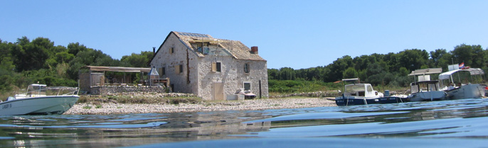
SAVUDRIJA (45° 30’N; 13° 30’E), village (pop. 349 in 1991) and small harbour N of point of the same name (round, white stone lighthouse, with top gallery, white flashes).
Mooring: The harbour is exposed to SW and NW wind. In other winds suitable as shelter for small craft only. Mooring at pier (depth 2.5m), at north part of pier with four-point moor.
Warning: When entering harbour care should be taken to avoid shoals extending about 1.2M offshore from the point. Customs and registration should be made previously in Umag. A large tourist settlement with a motel, bungalows and a campsite is situated near the point.
UMAG (45° 26’N; 13° 31’E), town (pop. 4,838 in 1991) and harbour on NW shore of Istrian Peninsula.
Approach: Landmarks: the hotel complex N of the harbour, Adriatic hotel in the harbour, church belfry surmounted by a pyramidal point, factory chimney S of town, green tower with column (green light) at head of breakwater, red tower with column (red light) and gallery at head of marina breakwater, square white tower (red light) on main pier of harbour.
When entering harbour care should be taken of a number of shoals. The western edge of the Paklena (hellish) shoal on the north entrance to the harbour is marked by a cylindrical red tower with a column and gallery (white-red sector light) on a white stone base; the southern edge of the rocky Garofulin shoal, also on the north entrance, is marked by a yellow and black post and two cones, points downwards, (sea is shallow to about 60m south of marker).
Incoming yachts should enter harbour passing between the red, conical light-buoy (must be left to port) and the green, conical signal buoy (must be left to starboard). Only after passing the green conical light buoy (leave to starboard) course may be shaped for the pier; at night, until the red light on its head is sighted. Depth of the entrance channel is 4m and more.
Mooring: The harbour is sheltered from all winds and sea except N and NNW. The bora may be strong but does not create waves. Summer storms are short but dangerous and form waves in the harbour. Yachts can moor beside the pier and on the east side of the quay. The pier is reserved for coastal and excursion yachts; in the sum- mer season it is used by customs authorities. Yachts and smaller yachts are advised to moor in the marina (north part of har- bour). There is good anchorage in the centre of the harbour (depth 35m). Larger yachts are advised to anchor about 0.6M west of the Umag belfry (depth 18m). At night they should anchor 2M west of the harbour (depth 27m). This anchorage provides shelter from the bora but at first signs of a S or SW wind yachts should weigh and leave.
Umag is a permanent port of entry and has harbour master’s branch office, customs, post office, hospital, out-patients’ department, chemist’s, bank, hotels and hotel settlements (Katoro, 1 M north of harbour), casino, camp for motorists. It is the seat of Umag Fishing Club and the Youth Sailing Club Hempel Albatros of Bujstina.
Facilities: Water hydrant at base of pier, fuel near pier, super- market, duty-free shop, nautical supplies, charts and nautical publications.
General repairs of yachts in Umag marina.
Every year the traditional Umag May Festival is organized.
Sights: Remains of the town walls (14 C, one tower houses the Town Museum); Sv Marija Velika church (Great St Mary, 18 C, Gothic polyptych). Buje (defence walls, loggia, town mansions) 13km; Groznjan (town walls, summer art and music centre) 26km. Oprtalj (medieval town walls, 15 C church) 40km. Motovun (walls, towers, town gate, 16 and 17 C, old houses, fine view across the Mirna valley) 36km. Istarske Toplice (spa with hot radio-active waters, in use since 17 C) 38km. Buzet (medieval necropolis, town walls and gates from 1547 and 1592, Town Museum) 48km.
UMAG MARINA (ACY) is located in north part of harbour in front of Adriatic hotel, road (1.5km) into town. Protected from all winds except N and NW. In spring and July winds from SW are most dangerous. High seas during summer storms do not last long and come from the west. There is a permanent warning and information service. All weather reports and forecasts are available in the marina offices.
The marina has 260 sea-berths for craft up to 18m (four-point moor) and area for 150 yachts at the pier. In 1993 it will expand its capacity for 310 more berths.
The marina is open all the year round.
It has reception office, restaurant, shops and duty-free shop, toilets and showers with hot water, water and electricity hook- ups, laundry, telephone; fuel; sports equipment and nautical equipment; car park.
Yacht hoist (10 t), travel-lift (40 t), slipway. Technical ser- vices: minor hull and engine repairs are available in Cervar- Porat marina and bigger in Portoroz marina or in Pula shipyard.
DALJA (45° 22’N; 13° 33’E), village (pop. 307 in 1991), small bay and holiday centre about 2.5M north of Novigrad.
Approach: The bay can be identified by the buildings of the tour- ist settlement on high ground above the shore and a wide tower with a flat roof in the settlement itself. Approaching yachts should be careful to avoid the Dajla (Pasador) shoal extending 400m NW of Dajla point; the northwest edge of this is marked by a yellow conical buoy with black band round the middle. This should be left to starboard.
Mooring: This shallow bay provides good shelter from the bora and the sirocco but is exposed to W wind and sea. Yachts may land in the NE part of the harbour (Spic), and moor at the head of the small pier (four-point moor), depth 2m at pier head, or anchor in the middle of the bay (depths 78 m) with a good holding bottom.
Facilities: Local shops, water in the hotel centre. Fuel and all other requirements in Umag or Novigrad.
Sights: Ruins of ancient buildings.
NOVIGRAD (45° 19’N; 13° 34’E), town (pop. 2,522 in 1991) and har- bour (on the peninsula on the S side of the bay).
Approach: Novigrad can be identified by ruins of the town walls, church belfry and white, eight-sided concrete tower (sector light) at the head of the breakwater and a white tower with column and gallery (green light) on the head of the pier.
Care should be taken to avoid two shoals at the harbour entrance: Val shoal (WSW of harbour) is marked by a cylindrical black buoy with red line roud the middle, topped with two black spheres; Meja shoal (at the root of the outer side of the breakwater). When approaching at night yachts should keep within the white sector of the light on the breakwater head. The Val shoal is covered by its red sector and the Meja shoal by its green sector. Mooring: The harbour is protected from all winds except W and NW which cause a surge in the harbour. As soon the first signs of N and NW winds are noticed yachts should transfer to Novigrad mar- ina. Yachts drawing up to 3.5m may moor along the breakwater, near the head, and on the NE side of the pier (four-point moor). The pier is also used by coastal and excursion yachts, and in sum- mer for customs. The best anchorage is about 200m NE of the pier (depth 34m
Novigrad is a seasonal port of entry; customs, harbour master’s branch office, post office; medical service, chemist’s. Ribon Fishing Club.
Facilities: Self-service (groceries), duty-free shop, navigation charts and publications, water and fuel in marina.
Sights: Part of walls with two towers, Sv Pelagije church (St Pelagius 8 C, with 15 C and 16 C additions, crypt), loggia and Gothic houses, stancija a typical Istrian country estate (1761) on Karpinjan headland. Town Museum in the Urizzi mansion.
NOVIGRAD MARINA is located SE of Novigrad harbour, about 100m from pier. Provides shelter from all winds and sea.
When entering harbour care should be taken of the shoals off Mujela point extending about 150m from shore and of Val shoal about 900m SW of breakwater.
The marina has 130 sea-berths (four-point moor without anchor) for smaller craft (drawing 1.5m) and room for about 50 yachts at the pier.
It has reception office; water and electricity hook-ups at the root of the pontoon pier. Slipway for small craft, crane (10 t); small repairs in marina, larger ones in Pula shipyard. Winter berthing with care and maintenance. Fuel and butane gas avail- able. Other supplies in Novigrad.
MIRNA (45° 19’N; 13° 34’E), wide bay S of Novigrad, estuary of river Mirna.
Approach: Novigrad lies on the N point at the entrance to the bay. There are steep red cliffs E of Pod Uliki point one mile E of Novigrad harbour and a lighthouse (sector light on corner of single-storey hous of lighthouse keeper) on Zub point (Rt Zub).
Yachts approaching from the north should take care to avoid the Val shoal, marked by a cylindrical black buoy with a red band in the middle, topped with two black spheres. At night this shoal is in the red sector of the harbour light (on the breakwater) in Novigrad harbour. Yachts approaching from the south should take care to avoid the Civran and Veliki skolj shoals lying about 1.6M south of Zub point.
Mooring: Mirna bay affords small craft shelter from all winds except those from the W which cause rough water. Larger craft are advised to anchor north of Valeta cove (depth 1718m) or in front of Stari Tar village. Smaller yachts can anchor near the S shore or in the Tar cove which is shallow (alluvial deposits). Anchorage about 1.6M south of Zub point. Yachts are advised to leave at the first signs of a W wind.
On the left bank of the Mirna, below the little hill town of Motovun, there is Motovun forest, a special forestry reserve; around Istarske Toplice there is a nature reserve.
CRVAR or CERVAR (45° 17′ N; 13° 36′ E), a long narrow inlet SE of point Zub. It forms two branches Lunga and Sveta Marina.
Approach: Yachts approaching from the north will see a light- house (single-storey building with white and red sector light) on Zub point, a holiday settlement S of the lighthouse, the build- ings of the hotel centre and the Cervar-Porat marina in the S part of Lunga. The large rocky shoal on the S side of the entrance to the inlet, the northern part of which is called Veliki skolj and the southern Civran, is dangerous for all yachts. NW of Veliki skolj shoal there is cylindrical green buoy (green light) topped by a cone pointing upwards. Both shoals are easily spotted because of the waves breaking over the rocks. On the SW edge of the Civran shoal is a yellow buoy with a black band (white light) in the middle, topped with two black cones, their points upwards. The shoals are in the red sectors of the lighthouses on Zub point and coastal light on Barbaran cliff, and must be left to starboard on entering Crvar. The marina should be approached by a course in the middle of the inlet.
Mooring: The inlet is protected from all winds except those from NW, depth in centre about 18m, and at marina entrance 14m. For about 200m along the north shore the sea is shallow (2m).
Facilities: Water and provisions in a supermarket in the village. General repairs in Cervar-Porat marina.
CERVAR-PORAT MARINA lies at the very end of the SE part of Crvar inlet, about 3M south of Novigrad harbour. It is well protected from all winds except that from the NW which causes a heavy swell in the marina and makes entrance difficult.
The marina has 300 sea-berths and about 50 dry-berths. Electri- city and water hook-ups. Anchoring in the marina is forbidden. Small craft can anchor N of the marina in Sveta Marina cove (depth 6m) or N of the cove (depth 15m).
The marina has reception office, a hotel with a restaurant, snack-bar, coffee-bar, toilets and showers, sports grounds, self-service shop.
Services include two cranes (5 and 10 t), equipment for transport and berthing of craft on land. A small slipway, maintenance and repair services to hull and engine, electrical installations, repairs to sails and masts. There is a 1.5km long bathing beach 500m from the village near to the Ulika naturist centre.
POREC (45° 14’N; 13° 36’E), town (pop. 7,585 in 1991) and har- bour, protected from S by a small peninsula and islet of Sveti Nikola.
Approach: Porec can be identified from a distance by a castle, the ruins of a tower and the camp site on the islet of Sveti Nikola. By the belfry with turret in the town, by a red cylindri- cal tower (white and red sector lights) on Barbaran cliff and a white concrete tower with green cupola (green light) on the head of the breakwater (islet of Sveti Nikola).
Yachts approaching from the N should take care to avoid the Meja shoal about one mile NNW of the harbour, the middle is marked by a black spar with two red bands topped by two black spheres. At night this shoal is covered by the red sector of the light on Barbaran cliff. About 0.5M from the Meja shoal care should be taken to avoid the Pical shoal (depth 2.4m). Yachts should keep well over to the west of the alignment of Rt point and Busuja point until abreast of Pical point. After that course can be shaped for the harbour. Yachts approaching from the south should take care to avoid the Bekarija shoal about 0.3M south of the islet of Sveti Nikola and marked with a black spar with two red bands and topped by two black spheres. There are underwater pipes and cables between the shore and Sveti Nikola.
There are four approaches to the harbour; the safest being the channel between Barbaran cliff and the head of the north breakwa- ter on Sveti Nikola islet. At night this channel is in the white sector (62° to 153°) of the light on Barbaran.
Mooring: The harbour is protected from NE and to some extent from SW and NW. Winds from S and NW create high waves. The sirocco here is more frequent than the bora wich blows very strongly, especially in autumn. In summer during the sirocco SW squalls may be experienced and these cause high waves in the harbour. Strong sea currents may make maneuvring difficult in the harbour. Yachts drawing up to 5m can moor at the quay in front of the Rivijera Hotel and those drawing up to 4m at the pier which also serves coastal and excursion yachts and for customs. There is anchorage in the middle of the harbour but it is not recommended as there is no good holding bottom. If strong SW or W winds blow the best anchorage is below the NE shore of Sveti Nikola islet.
Porec harbour is a permanent port of entry; customs, harbour master’s branch office, post office, several hotels and hotel settlements, banks, hospital, medical services, chemist’s. It is the seat of the motonautical club and Zubatac Fishing Club.
Facilities: Water hydrants in the E part of the harbour (depth 3m) and on the foreshore, fuel pumps on the waterfront in front of shops. The duty-free shop sells charts and nautical publica- tions. Other supplies may be bought from the town shops.
Small repairs to hull and engine available.
Annual events: art exhibitions and summer art festivals.
Sights: Ruins of temples of Neptune and Mars (1/2 C), Roman street layout, Eufrazijeva bazilika (Basilica of St Euphrasius, 6 C, baptistery, atrium, Maur oratory, mosaics, ciborium), canon’s house (1251), Sv Franjo church (St Francis, 13 C, collection), Two Saints’ House (12 C, Romanesque/Gothic, exhibition hall), the Sincic mansion (17 C, Porec Regional Museum). On the isle of Sveti Nikola (half a mile from the harbour): remains of an Illyrian building (3 C B.C.), lighthouse (1409, oldest lighthouse on the eastern Adriatic). Beram (Sv Martin church, 1431, 19 C additions, frescoes, Sv Marija na Skrilinah church, frescoes from 1474; Vladimir Gortan’s monument) 27km. Pazin (1214 C castle, Pazin National Museum; Sv Nikola church, 1266, additions in 1441 and in 18 C, frescoes, church museum; Franciscan church 146377) 32km. Sv Petar u Sumi (13 C church and monastery, reconstruc- tions in 1459, 1731, 1773, cloister) 42km. Lovrec (church, 911 C; loggia, medieval town walls) 17km.
PLAVA LAGUNA (45° 12’N; 13°36’E), small harbour and hotel settle- ment in the bay of the same name about 1.5M south of Porec.
Mooring: The 20m concrete pier largely protects the harbour from the SW and NW. Only yachts drawing up to 3m can moor. The outer side of the pier is reserved for hydrofoils that ply between Porec and Plava laguna (the Blue Lagoon).
Facilities: Food and water. Small slipway S of little pier.
Plava Laguna Sailing Club.
PARENTIUM MARINA (ZELENA LAGUNA), marina and Parentium holiday settlement on the S shore of Mulandarija bay (2M from Porec).
Approach between Regata rock (NW of the point at the N entrance) and the Zontulin and Zontuja rocks about 500m W of point at S entrance. The rocks are not marked at night and the approach is difficult.
The marina has 200 sea-berths (four-point moor) and 50 dry- berths. On breakwater and piers there are water hydrants and electricity hook-ups.
Fuel in pumps in marina, charts and nautical publications in duty-free shop, other purchases in local shops of marina and Porec and in Lotus, Albatros, Galeb and Delfin hotels.
Hoist (2 t) and slipway for small craft, transport of yachts; small repairs to hull and engine, for larger repairs Cervar-Porat marina and Pula.
FUNTANA (45° 11’N; 13° 36’E), cove about 3M south of Porec. On the south-eastern shore is the little village of Funtana. In the cove Frnazina holiday centre with several hotels and an autocamp.
Approach: Funtana with its church belfry on a rise above the cove is conspicuous and on the main angled pier a red post with red light.
Warning: From Porec to the entrance to the Limski kanal there are a large number of dangerous shoals and rocks. On the N side of Funtana bay is the Janjci shoal, its northern edge is marked by a black post with two red bands and topped with two black spheres. At the southern entrance, between the islet of Veli skolj and the shore is the Funtana shoal marked by a yellow and black post topped by two black cones, their points upwards. West of the pier, about 200m from the shore there are dangerous rocks and cliffs.
The safest approach is from the west, care being taken to avoid the Janjci shoal.
Mooring: The cove is exposed to W and NW winds and yachts should leave as soon as any signs of the W wind are noticed. The depth is 1.52m (four-point moor recommended). There is anchorage in them middle of the cove at a depth of 68m. Landing may be made at the head of the pier of the Frnazina holiday centre (depth 24m).
Facilities: The Frnazina holiday village has post office, medical service, shops and a restaurant. Fuel at Vrsar (about 4M); also more complete supplies.
VRSAR (45° 09’N; 13° 36’E), small town (pop. 1,624 in 1991) and small harbour 1.5M north of entrance to Limski kanal, sheltered from the SW by the islet of Sv Juraj.
Approach: Vrsar can be identified by the old castle above the town itself built on a steep hillock; On the islet of Galiner, at the entrance to the harbour, there is a square red tower topped with an iron construction (white light) and hotels S of the pier; a white tower with a red column (red light) at the head of the main pier.
Care should be taken of a whole chain of shoals 11.5M west of the harbour: Velika shoal (yellow and black cylindrical buoy), Mramori shoal (red cylindrical tower with column and gallery on a concrete base; red flashing light), Lunga rock (yellow cylindri- cal concrete marker with black band in middle and two black cones on top, points facing), Galopun rock (between Lunga islet and shore), Orlandin rock about half a mile SW of Galiner islet.
The safest approach to Vrsar is from NW leaving the Mramori shoal 300m to starboard; On entering the bay Galiner islet should be left slightly to port. If entrance is made from SW then the marker on Mramori shoal should be left 200300m to port and course set towards Galiner islet. At night approach should be made in the white sector of the light on Galiner islet (sector 5064° and 100116°).
Warning: It is forbidden for any yacht to sail between the isle of Sveti Juraj and the shore within a zone marked by: pier in the SE part of Vrsar harbour (sports centre of hotels) NW shore of Sv Juraj; Fornace point SE shore of Sveti Juraj. Craft of all kinds are also forbidden to sail within a zone: Bojko point NW shore of Kuvrsada islet (nets), Sjole point SW shore of Kuvrsada islet. These are forbidden zones from April 15 to October 15 every year.
There is a water-skiing track from Funtana point to Fujaga point.
Mooring: The harbour is protected from all winds except from NW. In strong south-westerlies the whole pier is flooded. Coasters and excursion yachts moor alongside the pier, craft may moor along the shore (four-point moor). There is good anchorage between the islet of Sv Juraj and the shore (depth 1215m). In strong NW winds anchorage should be made on the lee side of the island.
Facilities: Post office, medical service, chemist’s, exchange office, several hotels and hotel settlements, camp for motorists, duty-free shop. Food and water (hydrant); fuel pumps, butane gas. On Kuvrsada there is a naturist camp and bathing beach.
Sights: Traces of a Roman settlement in harbour and islets; Sv Marija church (12 C); Castel Vergottini medieval town gate (18 C). Kanfanar (Sv Silvestar church with medieval furniture and fittings) 28km. Dvograd (ruins of a medieval town deserted in 1630 because of the plaque) 31km.
LIMSKI ZALJEV, bay about 5.5M long and average 500m wide, about 3M north of Rovinj. Inland from its head extends the karst valley of the small seasonal river Lim. The sides of the bay are steep and overgrown with macchia. Powerful freshwater springs gush up from the seabed at the shore especially during winter months. The depth at the mouth of the bay is about 30m and at the head about 10m. There are underwater pipes and cables across the entrance to the bay. Limski zaljev is a legally protected centre for fish breeding and shellfish.
Warning: It is forbidden to sail or anchor in the bay without special permission.
Approach: Hotels on Sjole point are conspicuous. The Lim shoal is marked by a large cylindrical buoy with a red band round the mid- dle topped by two black spheres.
Caution must be exercised when entering the bay to avoid the Kuvrsada shoal north of the entrance bay (marked with a cylindri- cal buoy with a black post and red belt round the middle, topped with two black spheres). Kuvrsada inland is linked with the main- land by a bridge (on the posts). The Lim shoal in front of the entrance is marked by a cylindrical buoy with a black post and a red belt in the middle topped by two black spheres. The Fujaga shoal on the north side of the entrance is marked by a black and yellow post topped by two black cones, points downwards. If approaching from the S, about 500m SSW of Kriz point is an unmarked rocky shoal (depth 3.2m).
Facilities: Very limited (motel and inn on sea front, the sea- sonal Viking restaurant).
Sights: Illyrian remains (4/3 C B.C.), ruins of a Benedictine Abbey (12 C) and Old Christian church (6 C, remains of frescoes); Sv Marija church (St Mary, 1041).
VALALTA MARINA is located in Sveti Feliks cove S of the entrance to the Limski zaljev and part of the Valalta nudist centre.
When entering the marina from the W care should be taken of the rocky bottom which extends NW from the root of the breakwater.
The marina has 180 berths either side of the breakwater, by the pontoon pier and along the waterfront. There is only very limited dry-berth accomodation for yachts. Yachts should be four-point moored and lateral beside both side of the breakwater. There is good anchorage in the W part of Saline cove (depth 4m).
Tha marina operates in season only.
It has reception office, self-service and duty-free shops.
Slipway for small craft. Hydrants and electricity hook-ups. Technical services in Parentium marina and Cervar-Porat marina. Fuel in Vrsar.
ROVINJ (45° 05’N; 13° 38’E), town (pop. 12,910 in 1991) and har- bour on a peninsula and hill slopes. The harbour has two parts: southern (Sabionera) and northern (Valdibora).
Approach: Rovinj is easily identified from the sea by the belfry of Sv Eufemija church on the hill top, the chimney of the sardine cannery in the N harbour, the square white stone tower (white light) on Sv Eufemija point, and the islet of Sv Katarina S of the town.
When approaching the south harbour the passage between Sv Katar- ina islet and the cylindrical buoy with a post (black and red, two cones on top their bases together) which marks the E edge of a shoal (E of the islet), must not be used.
In Lon cove there is a submerged ship; its mast 1m above the sur- face of the sea.
Mooring: The north (Valdibora) harbour is well protected from the bora and sirocco but exposed to W and SW winds when the sea floods the whole quay. The south harbour is also well protected from the bora and sirocco but exposed to W and SW winds.
In the north harbour yachts drawing up to 5m may moor along the quay, smaller yachts can berth SW and NE of the quay.
If there is a strong SW wind, and at the first sign of summer gales, yachts should transfer to the south harbour. In the south harbour (Sabionera) the outer side and part of the inner side of the angled breakwater are reserved for passenger and excursion yachts; other yachts can berth at the root of the breakwater at the pier or along the masonry waterfront. It is advisable for smaller craft to bearth in the marina. When there are strong E and W winds a powerful current develops along the outer side of the breakwater which makes manoeuvering difficult.
Rovinj is a permanent port of entry; customs, harbour master’s branch office, post office; hospital with orthopedic surgery, medical services, chemist’s; duty-free shops, a large number of hotels, banks; the Mirna fish cannery, the Ru|er Boskovic marine research centre, an experimental fish farm, marine aquarium. Medusa Fishing Club. Maestral Yacht Club.
In the southern part of Mascin islet, joined by a narrow sandy causeway to Crveni otok (Red Island) is a naturist camp. Muntrav Park (under nature protection) with its hotels and bathing beach extends S of the town.
Facilities: Water hydrants in north and south harbours, all kinds of fuel from pumps in north harbour on the W corner of the water- front, other supplies in town shops and duty-free shops.
A yachtyard is located in the SE part of the south harbour (part of the Mirna food processing factory) which can carry out small repairs to wooden craft and servicing. Slipway for yachts up to 400 GRT.
In summer the art colony holds exhibitions in Grisia street.
Sights: Sv Eufemija church (St Euphemia, 1736, on the site of an old Christian church), Sv Trojstvo chapel (Chapel of the Holy Trinity, 13 C), Loggia (1592), clock-tower and Balbi arch (1680), Town Hall (17 C, museum). In the graveyard there is an avenue of cypresses which is a natural monument. Svetvincenat (graveyard church with frescoes, Sv Marija church, 16 C, Grimani mansion 1589) 33km. Barbariga (Roman villa rustica, 1 C) 8km.
A number of areas around Rovinj (the forest and park on Zlatni rt, the islets fronting the town and an area along the coast) are under protection as nature reserves.
OVINJ MARINA (ACY) is in the SE part of Rovinj harbour (Monte ulin), beside the shipyard, surrounded by pine-woods, 1km by oad from the centre of the town. Islet of Sveta Katarina and a reakwater protect it from all winds except the SW wind which eldom blows except in late autumn and winter when it is angerous; the W wind causes a heavy swell.
he marina has 380 sea-berths up to 15m (four-point moor) and 120 ry-berths. Water and electricity hook-ups are on pontoon piers nd on the pier.
he marina is open all the year round.
nchorage in Valdibora bay (N of the belfry of Sv Eufemija hurch), depths 2024m, 300m offshore; recommended anchorage in ront of the south harbour is 500 m NW of the centre of Sveta atarina islet, 600 m SW of the islet of Banjol or 300 m SSW of veta Katarina. Small yachts and yachts can anchor a little urther east. If the bora blows wessels should anchor in abionera bay (southern harbour) south of Sveta Katarina islet, epth 615m.
he marina has reception office, restaurant, shop and duty-free hop, toilets and showers with hot water, laundry, sporting quipment. Yachts can be hired (charter).
rane (10 t) and a small slipway. Modern workshops for all kinds f repairs to hull and engines. Larger repairs can be carried out n Rovinj.
ermanent information and warning services concerning weather, torms and tides. The marina offices offer weather forecasts and eports.
SVETI ANDRIJA also Crveni otok (45° 03’N; 13° 37’E), small har- bour and hotels on the islet of the same name, about 1.5M south of Rovinj.
Approach: Yachts may guide themselves by Sv Ivan na pucini ighthouse, the eight-sided tower beside the lighthouse-keeper’s ingle-storey house (white flashes).
n approaching the north shore care should be taken of shoals arked by a yellow spar with a black band in the middle (100m W f Samer rock), two black cones on top their points towards each ther. On the north shore of the islet to the shore at Kurent oint there are underwater cables and pipes. Anchorage S of the arbour is prohibited.
Mooring: Small north and south (for landing of small craft) arbours. The pier in front of the hotel in the north harbour is xposed to wind and sea from NE and NW, the southern harbour is xposed only to SW winds. Depth at head of landing stage is about m and at the head of the SW and NW piers of the southern harbour bout 2.5m, the harbour is a shallow one. Four-point moor beside he pier in the northern harbour and lateral berthing on both ides of the south harbour.
Facilities: Water hydrant in south harbour. Other requirements in ovinj.
AZANSKI KANAL, passage between the shore and the Brijuni islands s marked by a line: in the north of Barbariga point Kabula reef nd in the south Prostina point Pinida (Peneda) point.
Approach: This is a very rocky shore with many shoals and reefs 00400m offshore. Beside the islands the sea is shallow. On pproaching the channel the Brijuni and its characteristic build- ngs and vegetation are conspicuous. Care must be taken to avoid: abula reef (black and yellow tower with column and gallery, two lack cones, points upwards, white light) on the NW part of Bri- uni; the Mrtulin shoal cylindrical buoy with post and two black pheres, coloured black with red band in middle) on the eastern ide of the north entrance; the shoal S of Fazana (2 green coni- al buoys); Saluga shoal (cylindrical shoal red tower with post nd gallery; sector light red sector danger) S of entrance to rijuni harbour; Rankun shoal (cylindrical red buoy with pyramid onstruction, red light) E of point of same name on Veli Brijun; otez shoal (cylindrical tower with post and gallery) E of Rankun hoal. here are a number of anchorages in the channel for small craft specially when SW and SE winds blow; in front of Maric cove, in ront of Fazana and Brijuni harbours and in the Verige and Ran- uni coves. A NW wind causes a swell in the N part, and winds rom SW and SE in the south part of the channel. There is a con- tant NW current. During flood tide and when there are S winds he current attains a speed of 3 knots.
arning. Between Fazana and Brijuni islands there are a number of nderwater cables and pipes.
AZANA (44° 56’N; 133° 48’E), small town (pop. 2,716 in 1991) and arbour on eastern shore of Fazanski kanal (opposite Veli Brijun sland).
Approach: The church belfry is the main landmark. The harbour is nclosed by a breakwater to the N (at its head a red cylindrical ower with red light) and to the S a pier (on its head a white ylindrical tower with greeen light).
hen the harbour is approached from the S care should be taken of he shallow rocky bottom extending 400m offshore. The western dge of dangerous shoals is marked by two green conical buoys, hese should be left to starboard. A number of underwater pipes nd cables are laid between Fazana and Veli Brijun island.
Mooring: The harbour is protected from NE and SE winds and sea; W nd NW winds are dangerous because they cause rough sea in har- our. Anchorage is 0.3M northwest of the harbour. Only small raft can berth in the harbour moored at the pier. The depth at he smaller pier is about 2m and at the southern pier 3.54.0m. On he pier there is a hydrant and electricity connnections.
Facilities:. Hotel, several restaurants, medical services, recep- ion offices for excursions to Brijuni.
RIJUNI (Veli Brijun, Mali Brijun, 11 small islands and a consid- rable number of rocks and reefs), islands separated from the ainland by the Fazanski kanal.
Approach: There is a castle on the top of Veli Brijun, a shore ight on Pinida point (white isophase light); black and yellow ower with black post and gallery and 2 black cones, points pwards (white light) on the Kabula rock (see Fazanski kanal).
he islands have been inhabited since prehistoric times and speciaally in Roman times (from 2 C B.C.). There are the remains f a number of settlements and castles in the cove of Veriga, the emains of a Temple of Venus and of a 6 C basilica. From the Mid- le Age there is a Byzantine camp-site, the three-nave basilica f a Benedictine monastery. Venetians made extensive use of the tone quarries on the islet of Jerolim and built fortifications n several places. During malaria epidemics in the 17 C the slands were almost deserted but at the end of the 19 C anti- alarial precautions began to be taken (Robert Koch), hotels were uilt and planting began of Mediterranean and exotic vegetation. iped water was brought from the mainland and Brijuni became an nternational leisure centre. The mild climate fosters the growth f Mediterranean plants in natural parks. On Veli Brijun there is zoo with many kinds of animals. In 1984 the Brijuni were eclared a national park and the islet of Vanga a memorial cen- re.
ULA (44° 52’N; 13° 50’E), city (pop. 62,378 in 1991), port and arina at the SW end of the Istrian peninsula. It lies in a atural bay sheltered by a peninsula and breakwater.
Approach: The signal station on Muzilj hill (on peninsula S of arbour entarnce), the red light on Prostina point N of entrance square stone tower the upper part coloured red), green light on he head of the Kumpar breakwater (green tower with a post and a allery) and the light on Pinida point (square tower beside ouse, white isophase light) are easily identified from seaward. hen approaching at night keep to the middle of the channel and hape course for the red light on the S side of Sveti Andrija slet; when a clear passage can be seen between Sveti Andrija and veta Katarina course may be shaped for the passage between the wo islands and bezween two pairs of light markers (port-red, tarboard-green) which lead to the E part of the harbour. The assage between the two islands is marked by two red cylindrical owers with red lights on the NW side, and two green cylindrical owers with green lights on the SE side.
estricted and forbidden zones. From the alignment Prostina point umpar point to alignment Sveti Andrija island Sveti Petar pen- nsula yachts must sail at a speed of less than 8 knots, and rom this zone onwards at a speed of not more than 5 knots. essels must pass the ships moored at Uljanik shipyard at the reatest possible distance. Workyachts with divers and frogmen on oard must be passed at minimum speed and with engines stopped. n the passage between Sveti Andrija and Sveta Katarina islands ncoming yachts must give-way to yachts leaving port. In this assage yachts are forbidden to use sail as their only means of ropulsion. Yachts must not approach within 50m of Sveti Andrija nd Sveta Katarina islands and the mainland coast E of the end of he Fizela vela cove (Lucica) and the piers in Pod stine cove at umpar point. Pleasure yachts, motor-yachts, sailing-yachts and peed-yachts must not approach within 50m of bathing beaches and wimming establishments marked with protective nets. Water-skiing s prohibited in the harbour area.
veti Petar peninsula and the islets of Sveti Andrija and Sveta atarina divide the harbour area into an outer and an inner har- our.
Mooring: In the inner (commercial) E part yachts can berth at the ijeka Pier (Gat Rijeka, depths 3.57.9m) at Arena quay (depths .56.0m) or Marshal Tito Quay (depths 2.56.0m). It is recommended o moor in Pula marina. There is anchorage about 400m NW of ijeka Pier (8.5m).
he section of the waterfront from Marshal Tito Quay to the ship- ard bridge is reserved for fishing yachts. The best anchorage for arge yachts is WSW of the railway station.
ula is open to international sailing and is a permanent port of ntry. Harbour master’s office, customs, sale of charts and navi- ation publications (PLOVPUTPlovno podrucje Pula Sailing in the ula Area, in harbour master’s office building); railway station, ost office, medical service, hospital, chemist’s. Uljanik and vijaticar Fishing Clubs, Uljanik Sports club (Veruda bay) and ornar Yacht Club (Soline bay).
Facilities: Water from hydrant; fuel station on the small pier in ront of the harbour master’s office; duty-free shop, nautical quipment and storage facilities (Brodokomerc).
here is a 15 t electric crane at the shore end of Rijeka pier; ljanik shipyard can carry out all repairs to hulls and engines f all sizes; this work can also be carried out in Pula and ljanik shipyards.
ar-ferry line: PulaMali LosinjSilbaZadar.
t the beginning of July the Istria Regatta is organized in Pula PulaPorecUmagRovinjPula), and during July a Film Festival.
Sights: Kastel (after 177 B.C., alterations in 13 C and 1631), oman Amphitheatre (12 C, 23,000 spectators), Slavoluk Serge- evaca (Triumphal Arch of the Sergians, 1 C B.C.), Porta Gemina 2/3 C), Roman mosaic showing the punishment of Dirce (1 C, Ulica rvog maja), Temple of Augustus (1 C), Cathedral (45 C, recon- tructions in 15 C and in 1640), chapel in the church of Sta aria Formosa (about 556, mosaic), Sv Franjo church (St. Francis 4 C, polyptych), Town Hall (1296, restored in 1653), Archaeolog- cal Museum of Istria with collection of stone monuments and ragments, Theatrium Iuliae on Monte Zaro (1 C). Vodnjan, Sv laz church (St Blasius, rich collection of liturgical items; own Hall with art collection) 10km. Valtura (Illyrian settle- ent, Roman colony of Nesactium in the village of Vizace) 11km.
PULA MARINA (ACY) is in the SE part of the city harbour (Istra ier).
There are sea-berths for 220 yachts at the pontoons projecting rom Istra pier, (depth 48m) and 100 dry-berths. Water, electri- ity and telephone hook-ups.
The marina has reception office, restaurant, shops and duty-free shops, coffee-bar, toilets and showers with hot water; laundry; car-park; fuel pumps (150m from marina).
Small repairs to hull and engine and electric installations can be carried out in the marina. Larger repairs in Pula and Uljanik shipyards.
he marina is open all the year round.
ERUDA (44° 50’N; 13° 50’E), cove and islet 3.2M from Kumpar oint (about 4M south of Pula).
Approach: White tower with red top and gallery beside house (red ight) on Verudica point, ruins of monastery on Veruda islet; uildings of hotel complex at the NW entrance point and marina ffices are all visible from seaward. eruda is sheltered from all winds and sea. When approaching care hould be taken to avoid a rocky shoal about 150m SW of Verudica oint. Yachts should hold to the centre of the bay because of hoals along the shore.
Mooring:In Veruda Marina.
ERUDAPULA MARINA is situated on the eastern shore of the north- rn cove of Veruda harbour, 3.5M south of Pula. Provides shelter rom all winds and sea, but outer breakwater exposed to S and SW inds. Weather reports and forecasts provided by the marina.
he marina has 17 concrete piers (average depth 3.5m). There are erths for 688 yachts up to 30m in length (four-point moor, bow or tern to pier) and about 150 dry-berths for repairs and winter- ng. Berths can be reserved by phone. All berths are provided ith water and electricity hook-ups.
here is a good anchorage N of marina (depths 45m).
he marina has reception office, shop and duty-free shop, restau- ant, pizzeria, supermarket, exchange office, near the W shore of he bay there is a holiday centre with shops. Fuel and butane gas vailable in marina.
lectric crane (10-t); care, maintenance, servicing and cleaning f engine (esp. VOLVO and DUCATI), sails and electrical installa- ions available in marina. Larger repairs at Pula and Uljanik hipyards in Pula.
renaturist sports grounds (tennis, basketball, mini-golf, bowl- ng).
ALTANA (44° 49’N; 13° 52’E), cove about 5.5M southeast of Pula; anjole village (pop. 707 in 1991).
Approach: The cove can be identified by a stone pyramid topped ith post and sphere (mile measurement) and high antennae column n the S entrance point.
Mooring: The cove is protected from all winds and sea except from E and SW. In the northern part of the cove is a masonry water- ront (depths 24 m) beside which yachts may berth and also along he small pier in front of a fish cannery (depths 1.23m). There s anchorage in the middle of the cove at a depth of 4m. Two uoys are anchored about 300m from the entrance to the cove.
EDULINSKI ZALJEV (44° 46’N; 13° 55’E 44° 49’N; 14° 00’E), bay n the south shore of Istria between points Kamenjak and Marlera; he Kasteja peninsula divides it into two parts. The inner part s shallow and suitable only for small yachts (drawing up to m).
Approach: Premantura village can be identified by a belfry; in edulin village there is a church with two belfries (pop. 1,885 n 1991); the stone tower above a house on the Porer cliff (white ight), a square tower beside house (white light), on Marlera oint; the red and white pyramid on Fenera islet. Great care hould be taken because of the many shoals. The following shoals re marked: Fenera, NW of islet of the same name, marked with red nd black iron post topped by two black spheres; Konjina, SE of eja islet, yellow and black post topped by two cones, points ownwards; Ceja SW of islet of same name, green post topped by reen cone; Gajdarusa WNW of Ceja islet red post topped with red an.
he safest route for small craft is between Albanez shoal and orer rock (marked by a light). Approach may also be made between he shore (Krsina point) and Porer rock but great care must be aken of the dangerous (unmarked) rocky) shoal of Veliki Balun nd of Fenoliga shoal (cylindrical red tower, red light); depth f channel about 8m. About 250m S of Krsina point there is a hoal of the same name marked by a post topped by two black cones oints downwards. Course may be continued towards Fenera islet. his shuold be passed on the S side and course may then be shaped oward the channel between the islets of Bodulas and Ceja (within he white sector of the light on Munat point; red cylindrical- ower). Approach may also be made between Kamenjak point and Fen- ra islet; then E of Sekovac islet, leaving the Ceja shoal to tarboard (marked by post topped with green cone), then shape ourse for Medulin belfry, E of the islet of Trumbuja. In the nner part of the bay it is advisible to keep in the middle of he starits between points Munat and Kasteja; after passing abeam f the Trumbuja islet, hold to the middle of the channel towards omerski skoljic islet until the details of the marina become lerly visible. In approaching Pomer marina the Premanturski koljic islet should be left to port. Should approach be made by ight the utmost caution is necessary.
he outer bay is exposed to S winds which cause limited visibil- ty, the bora, too, is rather strong and lasting. Bad weather can e expected when clouds appear over Osorscica hill (Island of osinj).
Mooring: Larger yachts can anchor between the islets of Ceja and rumbuja (depth 20m), smaller craft are advised to use the nchorage protected from all winds in the passage W of Kasteja eninsula and S of Pomerski Skoljic islet. Small craft can berth eside the two piers in Runke cove (depth 3m) or opposite the E hore beside the path with the hoist (depth 2.5m); at the filling tation for butane gas, restaurant and supermarket.
here are shellfish beds in the N part of the bay. Underwater ables and pipes are laid between points Munat and Kasteja.
Facilities: Food in local places, water on Kasteja point, fuel in edulin which has post office and medical service.
Sights: Mutila Roman villa rustica; Roman graves and baths on izula peninsula.
OMER MARINA (ACY) lies in the NW part of Medulin bay south of omer village, 10km from Pula.
here are 5 piers with 250 sea-berths (22.8 m) and 100 dry- erths; electricity hook-ups.
uring long lasting sirocco a swell develops in the marina, the ora and tramontana make sailing difficult. There is good nchorage E of the alignment: Pomerski skoljic Premanturski koljic, depths 68m.
he marina has reception office, restaurant, duty-free shop, oilets and showers with hot water; sports grounds; car park; uel pump.
rane (10 t) and slipway for small repairs to hull, engine and lectrical installations. Larger repairs available at Pula and ljanik shipyards in Pula.
ermanent information and warning service concerning storms and ide waves, weather forecasts and navigational messages.
he marina is open all the year round.
UJE (44° 49’N; 13° 59’E), cove and anchorage for small yachts n the SE shore of Istria (SE of Liznjan village).
n approaching care should be taken of the Sika shoal and rock 00m offshore, SE of harbour. At night the shoal and rock are in he dark sector of the Marlera lighthouse.
he little harbour is sheltered from all winds except those from E.
INJOLE (44° 55’N; 14° 02’E), indented bay and shelter for small raft on the SE coast of Istria.
uga uvala hotel appartment settlement. Hotels, restaurants.
n approaching care should be taken of shoals in the centre of he entrance to the bay (depth 0.3m). Exposed to winds and sea rom SE, the bora is also strongly felt.
KRNICKA LUKA also Krnica (44° 57’N; 14° 03’E), village (pop. 296 in 1991) and cove on W side of entrance to Rasa inlet (SE shore of Istria).
Sheltered from all winds except SE. Affords good anchorage for small craft at the inner end of the bay (depths 7.59m), small landing stage usually occupied by fishing yachts.
Shop and restaurant in the village.
RASA (44° 57’N; 14° 03’E 45° 02’N; 14° 05’E), a long inlet into which flows the Rasa river.
Approach: Landmarks: belfry in Krnica village, white iron tower (white light) on Ubac point, cylindrical red tower of open con- struction (red light) on Mulac point and stone pyramid N of that point.
Care should be taken when approaching to avoid the shoal NW of the pier at Brsica cove and the wreck in Salamuscica cove (about 1.5km NE of Rakalj village).
Also beware of intensive commercial traffic to the Trget and Brsica terminals. In the coves of Risvica, Salamuscica and Blaz there are shellfish beds.
The bora here blows in gusts and forms whirlpools. When there is a strong sirocco the swell is felt all the way down the inlet to Trget harbour (pop. 55 in 1991) which is the rail terminal of the industrial line from Lupoglav.
Mooring: Yachts drawing up to 6m can berth in the Brsica cove and smaller ones in Trget harbour. In this harbour its is best to anchor (four-point moor) S or SE of the harbour offices. The best anchorage for large yachts is in Tunarica cove, off the NE shore (about 2M from the entrance). The bora is somewhat less than in other parts of the inlet. Smaller craft are advised to anchor off the E shore of the inlet S of Risvica cove (bollards for stern moorings) and Teplica cove. The bora is felt strongly here and forms whirlpools. Shellfish beds in Risvica, Salamuscica and Blaz coves have no markers and are thus dangerous for navigation.
The harbour is open to international navigation and is a per- manent port of entry.
The town of Rasa (pop. 1,970 in 1991) is reached by road from Trget (10M); it has post office, medical services, chemist’s; Adria in Labin builds fibre-glass yachts.
TRGET (45° 01.4’N; 14° 03.4’E), small village (pop. 55 in 1991) and point at the end of Rasa inlet.
Approach: Green tower with post and gallery (green light) on Trget point about 0.2M northwest of town.
Mooring: Small yachts can berth beside the two small piers (four-point moor). The bora from the E is strongly felt.
Harbour branch office and customs.
Facilities: Water from the mains, shops in Rasa and Labin.
BRSICA (45° 01.8’N; 14° 03’E), cove and harbour at the bottom of the Rasa inlet serving Rasa and Labin (pop. 9,036 in 1991). Timber wharf off E shore of cove and livestock wharf at Tpier.
Approach: Steep whitish cutting behind a concrete platform; three harbour cranes, iron tower (light green) on Trget point.
Mooring: There is a masonry waterfront NW of the steep pier. Small craft can only moor at the small number of buoys. The sirocco is felt here with great force, the bora is fierce and blows in gusts.
Harbour branch office, customs and post office in Trget (1.5km).
Warning: Alluvial sediments brought down by the Rasa river causes variation in the depth of the sea which may be as much as 1m. When the river is in spate after rain, currents may make it dif- ficult to manoeuvre and sail into or out of the inlet.
Facilities: Water hydrant on the shore, provisions in shops in Rasa and Labin.
TUNARICA (44° 58.4’N; 14° 05.8’E), wide cove on the E side of the Rasa inlet, SE of Sv Mikula point.
Approach: Landmark: on the entrance point to N is a red column and post with gallery (red light).
Mooring: The cove is sheltered from all winds. Smaller yachts can moor beside the pier or anchor in the N cove (several stone blocks allow four-point moor).
KOROMACNO (44° 58’N; 14° 07’E), village (pop. 269 in 1991), cove and point on the E coast of Istria, W of Crna punta point. Pro- vides good shelter from the bora but is exposed to strong S winds and sea from SW to SE (if such winds develop, shelter should be sought in the Rasa inlet).
Approach: Landmarks: white cage on the corner of a stone house (white light) on Crna point, the chimney from the cement factory, village buildings and silos in the background, quarry in the hill behind and harbour cranes. In approaching the masonry waterfront care should be taken to keep at least 50m starboard of the stone blocks before the main, small pier SW of entrance.
The best anchorage for yachts is 0.5M northwest of Koromacno point.
Facilities: Limited amounts of food and water. Post office and medical service.
PRKLOG (45° 02’N; 14° 10’E), cove beside the point of the same name on the E Istrian coast about 2M south of Rabac; depth up to 39m. Protected from all winds but those from the S. Yachts may anchor or moor but only in cases of emergency.
Approach: The cove can be identified by the chapel on Sv Marina point.
Mooring: Yachts can anchor here in normal weather conditions and in emergency (good holding bottom), but the bora blows fiercely and S winds cause waves which makes it an uncertain refuge. Small craft can berth (four-point moor) at the bottom of the cove (NE of reefs).
Warning: At the bottom of the bay, just off the W shore, small reefs are above sea-level at low water.
RABAC (45° 06’N; 14° 10’E), tourist settlement (pop. 1,373 in 1991) and small harbour between Sv Juraj and Sv Andrija points on E coast of Istria.
Approach: Landmarks: Labin belfry (NW of harbour), a square stone tower (white light), the buildings of the hotel settlement on Sv Adrija point; NW of the point at the bottom of the cove there are more hotels.
When approaching care should be taken of Sv Juraj rock about 300m NE of the point of the same name.
Mooring: The cove is partially sheltered from the bora which, however, causes a swell. It is open to S winds and waves. On the N part of the E side of the cove there is a masonry waterfront; the N part, to the pier, is used by fishing yachts (depth 23m) and the yachts of the local people. The pier (5.56m) is reserved for coastal and excursion yachts. The built section of the S pier is used by the ferry to Porozina (if this cannot sail from Bres- tova). Yachts and small yachts should berth (four-point moor) at the most southerly part of the waterfront, in front of the hotels. Water and electricity hook-ups. On the NW shore is the wharf of a deserted mine. This is a dangerous place to moor when the bora blows.
The best anchorage for yachts of all size is in the NE part of the harbour.
Facilities: Harbour master’s branch office, post office, medical service, chemist’s, banks, several hotels and hotel settlements with shops. Groceries; fuel pump 500m from shore. Kvarner Yacht Club.
Services. The Oliva camp for motorists is beside the harbour. Crane (5 t); small repairs can be carried out by Rasa workshops.
Sights: Remains of town walls (1587), the site of the Roman town of Albona, buildings from medieval times to the Baroque period. Museum with a collection of stone fragments. About 5 km away is Dubrova where Mediterranean sculpture symposium is held collec- tion of sculpture.
PLOMINSKA LUKA (45° 06.8’N; 14° 12’E), deep cove about 3M northeast of Rabac. It is very deep and steep sided except at the end where inflowing streams make the seabed variable. The small town of Plomin (pop. 137 in 1991) is situated at the end of the cove.
Approach: It may be identified by the steep NE entrance at Masnjak point where there is a motel, the belfries of Plomin churches and the chimney of the thermo-electric power plant.
Mooring: The bora here is strong and dangerous and blows in gusts from SW, it blows in summer too, often unexpectedly. The sirocco causes a swell in the harbour. Anchoring is advisable in fine weather only (good holding bottom), anchoring is not recommended at the bottom of the bay because of the shallow rocky bottom.
Facilities: Water from the main. Provisions in local shops (lim- ited).
MOSCENICKA DRAGA (45° 14’N; 14° 15’E), village (pop. 472 in 1991) in Rijeka Bay, 7.5M north of the entrance to Plomin harbour.
Approach: Landmarks: the church belfry and buildings of Moscenica on the hill above the bay, a green tower with post (green light) on the SE corner of the pier, a valley extending from the moun- tains to the sea, by night the green light from the SE corner of the breakwater.
Mooring: The bay is exposed to all winds except those from NW. In winter a strong ESE wind blows and in summer gales are frequent. Sometimes the maestral blows here strongly from the S which makes landing very difficult. When the Mt Ucka is cloud capped bad weather from the S can be expected. Yachts can anchor or moor beside the masonry waterfront (four-point moor) but only in good weather. Only a limited number of small craft can berth in the inner harbour.
Facilities: Harbour master’s branch office, post office; medical services in the town; hotels, marina and camp for motorists. Pro- visions and water.
The seat of the Draga Sports Club and the Orion Yachtsmen Club.
Services. Hoist (3,5 t) in harbour.
Sights: Moscenica (medieval walls, tower and town gate, 17 C log- gia), Sv Andrija church (St Andrew 178090 with baroque interior, museum collection) 1M.
LOVRAN (45° 17’N; 14° 17’E), small town (pop. 3,640 in 1991) and small harbour S of Opatija.
Approach: Landmarks: the pointed belfry, the red building on the hill above the town, the hotel on the shore NW of the breakwater, a square green tower (green light) on the head of the breakwater.
Mooring: The harbour is exposed to the bora and sirocco and is not recommended for a long stay. E wind cause high waves (warning signs are a cloud cap on Mt Ucka and high sea level). During S winds currents make manoeuvering difficult. Moorings are continu- ously occupied. There is anchorage about 500m offshore in a depth of 30m, the holding is good but the anchorage is exposed to all winds except those from NW quadrant.
Facilities: Abundant water from town supply, fuel pump in town (about 800m).
Summer and health resort, hospital for bone tuberculosis and med- ical service; hotels, restaurants and shops, post office.
Zubatac Sport Fishing Club and Istra Sailing Club .
Sights: Stubica town gate towards the sea and tower (medieval); Sv Juraj church (St George, 16 C, wall paintings dating before 1479), Sv Trojstvo chapel (Holy Trinity, 13 C) on the shore; Baroque buildings on the square.
IKA (45° 18.3’N; 14° 17’E), old fishing village (pop. 477 in 1991) lying along the inlet formed by the inundated mouth of the Banina stream. Approach: Red sphere on a post (red light) on the main pier is a conspicuous landmark. Because of the shoal along the breakwater extension it is advisable to approach very carefully. From the bay E of the pier an underwater pipe extends in a SW direction.
Mooring: The small harbour is exposed to all winds except those from the N. South and E winds cause a choppy sea and yachts are not advised to make an extended stay.
Warning: From the inlet, E of the pier, an underwater pipe extends in a SW direction.
Facilities: Supermarket, fuel in Lovran (1M). Water from a hydrant on the shore in front of the hotel.
Services. Hoist (3 t) at the bottom end of the pier.
OPATIJA MARINA (ACY Grassetto) is situated between Opatija and Icici.
The marina has 6 piers. It is protected from the E by a breakwa- ter, depth 2.5m (near the shore) and up to 10m (beside the break- water). It has 400 berths (four-point moor) and 100 dry-berths. The marina will be extended north with additional 5 piers.
The speed of the yacht is limited at 2 knots.
The marina has reception office, restaurant, fast-food restau- rant, shops, duty-free shop, boutiques, sale of nautical equip- ment, snack-bar, toilets and showers with hot water, laundry ser- vices; technical service, car park, slipway, crane (15 t).
The marina is open all the year round.
OPATIJA (45° 20’N; 14° 19’E), town and holiday resort (pop. 9,073 in 1991); also a small harbour on the NW side of Rijeka Bay, about 4M from Rijeka.
Approach: The town can be recognized by the small grey stone church (without belfry with a copper dome), many hotels, the cylindrical white tower with post and gallery (red light, visible azimuth 137° through S to 354°) on the pier head a red tower with post and gallery (red light) on the breakwater head of the marina in front of the Admiral hotel.
Mooring: The outer part of the pier is for excursion and passenger yachts and is suitable for mooring in good weather. The inner side of the quay is suitable for yachts drawing up to 3m and is sheltered from all winds except the NE. The bora is moderately felt and always blows from the E. S and E winds cause rough sea. The inner part of the harbour is reserved for yachts of local peo- ple. The best berth for yachts is in the marina fronting the Admiral hotel (0.8M southwest of the harbour). Anchorage (about 500m offshore, depth 50 m) is not recommended in strong E and SE winds.
Opatija has harbour master’s branch office, customs, post office, medical centre for thalasotherapia, chemist’s, medical service, banks, a large number of hotels of all categories, varied shops, duty-free shops. It is the centre of the Adriatic Yacht Club (ACY).
Jadran Yacht Club can undertake winter care of a limited number of yachts. In early spring (March) it organizes an international sailing regatta for the Opatija Cup (Finn and Flying Dutchman classes).
Facilities: Fuel pumps on the outer part of the quay, hydrant on quay. Electricity connections by harbour offices. Shops of all kinds in town. Electric crane (5 t) on the inner part of the quay, manual hoist (3 t) on the outer quay. Small repairs can be effected in Admiral Marina, larger in the Kantrida shipyard in Rijeka.
Sights: The church of Sv Jakob ad Palum (St Jacob ad Palum, 1508, additions 1774, 1937), Villa Angiolina (1844, the beginning of Opatija as a seaside resort); Prvi Maj park (exotica). Veprinac (Gothic castello, town gate, loggia, St Mark church) 13km. Mount Ucka (1,396 m, sweeping views of Kvarner Bay and Istria) 20km by road. Kastav, little town with medieval remains (15 C church of Sv Fabijan i Sebastijan, 15 C loggia) 6km.
ADMIRAL MARINA (49° 19’N; 14° 18.4’E) is located in Opatija, mainly for Admiral hotel guests.
Landmarks: the large, white step-like building of the Admiral hotel standing above the marina and the cylindrical red tower with post (red light) on the main breakwater are easily visible from seaward.
The marina operates during the whole year.
It has 206 berths (four-point moor) for small yachts and yachts. On shore there are a number of dry-berths for repairs and winter- ing.
The marina is protected from all winds and sea, but strong bora and sirocco create a swell especially at the berths beside the breakwater (nearer the sea). This makes entrance very difficult and sometimes impossible. The marina offices provide weather bul- letins and forecasts.
Shops in the marina and in Opatija. Fuel available.
Crane (5 t), electricity hook-ups, water from hydrant, engine servicing, repairs to electrical installations, battery charging, sail repairs.
Maintenance during wintering.
VOLOSKO (45° 21’N; 14° 19’E), a typical old Mediterranean fishing village (pop. about 400 in 1991) clustered around a little har- bour.
Approach: Landmarks: the church with two pointed belfries, the red iron tower on the south breakwater (red light) and green at the head of the north breakwater (green light).
Mooring: The harbour is well protected from SW and NW winds. Other winds create dangerous waves in the harbour so any long stay by yachts is not recommended. Small craft, drawing up to 3 m, can berth beside the pier.
Volosko Sport Club is in Brajdica.
Facilities: In Opatija.
PRELUK (45° 21’N; 14° 20’E), small harbour at the extreme N end of Rijeka Bay, about 0.3M north of Volosko. It does not provide shelter from SE and SW winds and is exposed to the bora. Not even in summer is it recommended for anything but a short stay.
About 120m from the E point is a shoal (3 m).
Mooring: Larger yachts may anchor in the NE part of the harbour (good holding bottom). Small craft can moor at the operative coast (55 m, depth 1 m); crane (1.5 t).
Facilities: In Rijeka and the neighbouring camp for motorists (E side of the Preluk cove).
RIJEKA (45° 20’N; 14° 25’E), town (pop. 167,964 in 1991) and largest Croatian commercial port.
Approach: Rijeka can be approached from three directions: from Kvarnerski zaljev (Kvarner Bay) through Vela vrata (Vela Straits), between the peninsula of Istria and the island of Cres; from Kvarneric through Srednja vrata between the islands of Krk and Cres; from Velebitski kanal (Velebit Channel) through Tihi kanal (Tihi Channel) between the island of Krk and the mainland.
The following landmarks are conspicuous when approaching the har- bour: the high hexagonal tower of Mlaka lighthouse (black and white bands, white light), the pointed white steeple of the church on Kozala Hill (above the town), the building of the large city hospital, the large travelling crane of the Treci maj (Third May) shipyard to the left of the harbour, the green tower with gallery (green light) at the head of Rijecki lukobran (Rijeka breakwater).
West of the entrance to the main harbour lies Brgud, the harbour of the Treci maj (Third May) shipyard (green tower with post above a house, green light). In the E part of the harbour part of the waterfront is reserved for passenger yachts and the berthing of yachts. Rijeka harbour does not provide good facilities for yachts and is not suitable for a longer stay. Large yachts will have great difficulty in finding a good berth in the harbour, the only available berths being in the E part of the main harbour (Karolina Rijecka Pier and E of this to Senjsko pristaniste). In entering and leaving yachts must keep to starboard and sail at moderate speed.
In spring and autumn the sirocco frequently blows (foretold by cloud cap on the top of Ucka). Nimbus and cumulonimbus clouds above the Velebit range usually herald W and NW winds, accom- panied by rough sea and strong slop in the harbour.
On the coast from Preluk to Bakarski zaljev are several small sports harbours (Kantrida, Treci maj, Jeleticevo, Grcevo) but they are crowded during the summer season and it is difficult to find a good berth.
Rijeka port is open to international sailing and is a permanent port of entry with customs and health authorities.
Facilities: Harbour master’s office, post office, train and bus terminals, airport (on the island of Krk) and airfield for sports planes (on Grobnik, outside of Rijeka), tourist offices, hotels, several hospitals, extensive medical services (outpatient’s department for seamen).
Rijeka has a university; shipping companies Croatialine and Jadrolinija; Treci maj shipyard.
The coastal maritime radiostation RIJEKARADIO forms part of Croatia Maritime Radio Service.
Provisions of all kinds are available in the town shops and the open market beside the harbour. Drinking water from hydrants and fuel (oil, petrol, gas) on the petrol station. Navigational pub- lications and charts are available from PLOVPUT Plovno podrucje Rijeka (Sailing in the Rijeka area, Senjsko pristaniste 3), and at the Maritime Faculty.
Repairs of all kinds to hull, engines, and all kinds of refitting available at Viktor Lenac shipyard in Martinscica. Repairs, ser- vicing and installation of engines up to 184 kW (250 HP) at Kan- trida yachtyard.
The seat of the Association for Sport Fishing and Underwater Activities is in Rijeka; Luben Fishing Club, Galeb Yacht Club (Kostrena), Treci Maj Yacht Club and Viktor Lenac Yacht Club. The central organization in Croatia for the international Flying Dutchman class, and international Sljuka class yachts are also in Rijeka, and the commodore fleet for the international Cadet class for the north Adriatic.
Carferry line: Rijeka Porozina; Rijeka (M. Losinj) Rab Zadar (Primosten) Split Hvar Korcula (V. Luka) Mljet Dubrovnik.
Sights: Sv Marija cathedral (13 C, renovations 1695, 171526, leaning belfry 1377), city tower (18 C), Capuchin monastery and church of Sv Jeronim (Baroque 18 C, Gothic chapel), Sv Vid church (St Vitus, rotunda 16381742), theatre (188586), Gospa Lurdska church in Zabica (Our Lady of Lourdes, in Zabica, 1906 and 1929), Calvary (remains of Roman limes), church (1934) and graveyard on Kozala (view of Rijeka Bay). Trsat: 538 steps of Petar Kruzic (lower part 1531), Frankopan castle (before 1288, additions in 19 C, fine view of Rijeka Bay), church of Marija Lauretanska (12 C, renovated 1824, rich inventory). History and Naval History Muse- ums, Natural History Museum with Aquarium, Zoo, Modern Art Gal- lery.
ZZURKOVO (45° 18’N; 14° 29’E), small harbour about 2.5M southeast of Rijeka.
Approach: The red cliff of the stone quarry W of the harbour is conspicuous.
Mooring: The harbour is exposed to SE and SW winds which do not cause waves. The bora may be violent. Small craft can anchor in the middle of the bay.
Facilities: Motel and restaurant. Water from hydrant on water- front, motel and restaurant, supermarket at the W side of the cove there is a petrol pump.
Brodoservis has a small yachtyard which can carry out repairs to small craft, such craft can also find winter berths. There is a hoist on the head of the main pier and two small slips.
Galeb Yacht Club of Rijeka.
BAKARSKI ZALJEV, bay about 6.5 miles ESE of Rijeka. It is very deep and the shores are steep and rocky. It offers no hindrances to navigation. The little town and port of Bakar lies the NW part of the bay and to the SE the village of Bakarac. On the west side of the bay there is a petrol terminal (Urinj refinery), a coking plant and Podbok terminal for bulk cargoes. The sirocco blows across the whole bay but neither it nor the bora form much swell. The bora blows frequently and very fiercely and in the SE part of the bay it changes direction. When the bora is strong it is advisible to sail as near as possible to the N shore of the bay.
The entrance is through Bakarska vrata. Care should be taken to avoid the shallows around Ostro point (isobath of 5m extends as much as 80m from the shore of the point). Bakarska vrata has the following light marks: to the W Babno point (red flashing) and Srednji point (white flashing); to the E there are buoys in front of Ostro point (green flashing) and Kavranic point (white flash- ing).
Mooring: Yachts can berth in the small harbours of Bakar and Bakarac. Strict regulations are in force for berthing in the industrial harbour.
BAKAR (45° 18’N; 14° 32.2’E), small town (pop. 1,853 in 1991) and harbour at the NW bottom of Bakarski zaljev (Bakar Bay).
Approach: The appearance of the town is dominated by a hotel and a church, there are facilities for underwater transporters on both shores, two light buoys; green to NE (green light) and red to SW (red light). Entrance course should be made between these two buoys. In winter the bora may hinder or make entrance or exit impossible.
Mooring: Yachts drawing up to 5m may berth beside Masaryk quay, and smaller craft with four-point moor beside this quay or in the hotel harbour.
Facilities: Harbour master’s branch office, post office, medical service, chemist’s, a number of restaurants and shops, customs, secondary nautical school. Water from a hydrant on the quay, all provisions from local shops, fuel from petrol pumps.
Crane (5.5 t) for yachts up to 6 m long and slipway for yachts up to 12m long at the Luben Sports Club.
Sights: Castle (16 C, additions 18 C), Sv Andrija church (St Andrew, 1830), buildings of bishopric (1494) and Plovanija (1514), baroque buildings, a Turkish house and a Roman house, Sv Margareta u Primorju church (St Margaret on the Littoral, 17 C), Municipal and Maritime Museum.
BAKARAC (45° 16.8’N; 14° 34.8’E), village (pop. 274 in 1991) and small harbour on the SE side of Bakarski zaljev (Bakar Bay).
Approach: Landmarks: the church belfry; red tower with post (red light) on the head of the main pier.
Mooring: Four-point moor in harbour or along the outer side of the breakwater. The bora blows strongly here and always comes unexpectedly. The sirocco does not cause waves.
Facilities: Post office, camp for motorists, motels and several restaurants in the village, water from the main; all other requirements in Kraljevica.