Ports and small yacht harbours
KREMIK MARINA is situated in the sheltered N cove of Peles bay, some 2M south of Primosten. The Adriatic highway passes in its immediate vicinity.
The marina has 350 berths at the quay (450 m) and the floating fingers (depth 215 m); there are 120 dry-berths. All berths are provided with water and electricity hook-ups (220 and 380 V). The marina operates during the summer season only.
It has reception office, customs, police station and harbour office; money exchange, phone booth, various shops (esp. of naut- ical equipment and tools). Parking lot for 200 vehicles nearby. Some 800 m from the marina there is a hotel, medical service and hairdresser’s.
A slipway (up to 50 t) and a hoist (5 t); repair of hulls, diesel engines and electrical installations; major repairs and overhaul at the yachtyard in Trogir. Security and maintenance of yachts out of season.
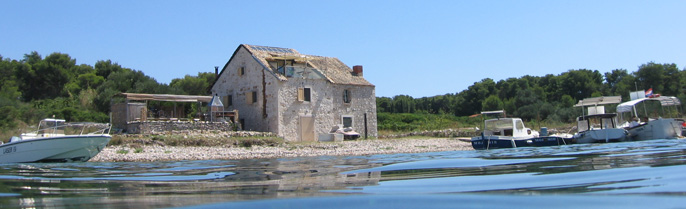
ROGOZNICA (43° 31’N; 15° 58’E), village (pop. 825 in 1991) and small harbour in the cove of the same name N of Ploca point; the safest shelter for yachts of all sizes in this part of the Adri- atic.
Approach: Landmarks: Movar Hill (120 m) and the eight-sided masonry tower; Mulo lighthouse, a stone tower next to the house (white flashes). Other landmarks include the round tower with a column and gallery with black and red bands (white light) sur- mounted by two spheres on Kalebinjak reef (in the passage between Smokvica vela islet and Konj point; the quadrangular red tower (red light) on Gradina point (in the cove); the green column (green light) ashore.
Mooring: The cove is protected from all winds. Yachts drawing up to 3.5m can moor along the S part of the mole fronting the vil- lage or along its N part (four-point moor). An achorage for larger yachts (indifferent holding ground) is in the E part of the cove, NE of Artic point (depth 2531 m). Smaller yachts can anchor in the W part of the cove, WNW of the harbour light (depth 2123 m) or in Stupin cove, NNE of the village (depth 36 m).
Warning: Navigation and fishing are prohibited in the N part of Lozica cove (NW of Rogoznica) in the area delimitated by the line connecting: S point of Jaz islet and Lukvenjak islet, bearing of 30° from Lukvenjak islet to the coast. It is prohibited to anchor in the area bounded by lines joining: from NW point of Smokvica vela islet in bearing 38.5° to the mainland coast; from Gradina point in bearing of 90° to coast of Rogoznica islet; from Varos point (in the S part of the cove) in bearing 0° to the coast of Rogoznica islet; from SW point of Smokvica vela in bearing of 128° to the mainland coast .
Sights: Uznesenje Marijino church (Assumption of the Virgin, 1615, renovated in 1746); in Stara Rogoznica Sv Nikola church (medieval, a graveyard with old tombstones), above the village an old mill and the remnants of a fortress (1809).
ISLAND OF VRGADA
SVETI ANDRIJA (43° 51’N; 15° 29.5’E), cove on the N side of Vrgada.
Approach: On the SW side of the cove, the reddish brown landslide is conspicuous; on the E side is an isolated chapel. The reef off the NE point of the cove (N coast of the island) is marked by a cylindrical concrete black and yellow mark and two cones point to point; the clear passage is W of the mark.
Mooring: The cove is open to NW but is protected from the bora; strong S winds cause a swell in it. Yachts drawing up to 2m can moor on the inner end of the small pier (only 15m from the root towards the head) in a depth of 2 m. At the head of the cove depth range between 0.5 and 1,0 m.
Sights: Sv Andrija church (St Andrew, 9 C?) at the cemetery.
LUKA (43° 51’N; 15° 30’E), cove on the E coast of Vrgada, the harbour of the village of Vrgada.
Approach: Landmarks: Artina islet off the NE point and the church on the hill.
Mooring: The cove affords good shelter from W winds. Approach is difficult during the bora. Only yachts drawing up to 2m can moor on the inner side of the long breakwater (four-point moor is recommended); poor holding.
Limited provisions and water available.
ISLAND OF MURTER
BETINA (43° 49’N; 15° 36’E), village (pop. 813 in 1991) and small harbour on the NE coast of the island.
Approach: When approaching from Pirovacki zaljev shape course for the white tower (white light) on Rat point and the stone column in the sea off the shallow point of Artic (N of the harbour); the green column (green light) on the breakwater.
Mooring: The harbour affords good shelter during SW and NW winds. Yachts can moor at the inner end of the breakwater. Anchoring is not recommended because of the poor holding (depth 3 m). The inner harbour is occupied by the local fishing-yachts.
Facilities: Post office and medical service, restaurant, shop; parking lot for 100 vehicles; harbour office in Tisno. Provisions and water available.
The shipyard in the marina builds craft 740m in length, carries out general repairs and maintenance of engines; they also look after and maintain yachts out of season. General repairs may also be undertaken at another, smaller yachtyard.
Sights: Remains of an ancient settlement (stone fragments, tomb- stones, pottery), Sv Franjo Asiski church (St Francis of Assisi, 1601, expanded 1720).
BETINA MARINA is situated NW from the village of Betina in the Zdrace cove at the N entrance to Murterski kanal.
Capacity: 190 sea-berths and 80 dry-berths; the berths have water and electricity hook-ups.
It has reception office, grocery store, chandler’s shop, duty- free shop, toilet with hot water, laundry; building, renovating and repairing of craft (wooden, metal, fiberglass) up to 44 m; engine repairs.
Launching and hauling-out of yachts (crane 10 t, travel-lift 260 t); slipway (30 t); there are 6 more slipways in the nearby ship- yard which can be used by the marina if necessary.
TISNO (43° 48.5’N; 15° 39’E), village (pop. 1,431 in 1991) and small harbour on the island of Murter, at the narrowest part of Murterski kanal. A bridge (does not open) links Murter with the mainland and divides the harbour into an eastern and a western part.
Approach: The western part of the harbour is approached from NW (Pirovacki zaljev) and the eastern part from SE (Murtersko more); the landmarks include the cone-shaped white tower with the green light on Maslinjak islet and the red column (red light) on the head of the breakwater.
The bora is strong and blows from various directions, but does not cause big waves. The harbour is less exposed to the sirocco and affords better protection from it. There is a strong SE current, especially with the south-easterlies and north- westerlies, when it may attain 4 knots.
Mooring: Yachts drawing up to 2m can berth on the inner end of the breakwater (SE of the bridge; the red column with a red light) or along the quay NW of the village (depth 2.5 m). There is a good anchorage in the SE part of the straits, NW of Ljutac islet (depth 2025 m).
An 800m long underwater sewage pipe extends some 900m E of the harbour (under the level of 65 m), bearing 143°.
Facilities: Harbour master’s branch office, post office, medical service and chemist’s.
Provisions at local shops, mains water supply.
JEZERA (43° 47’N; 15° 38’E), village (pop. 838 in 1991) in the cove of the same name on the NE coast of Murter.
Approach: Landmarks: the green column (green light) on the head of the L-shaped breakwater and the round tower with a column (red light) on the head of the breakwater in the marina.
The bay may be approached from both sides of Skoljic islet.
Mooring: Good all-round shelter for yachts of light and moderate draught. The four-point moor can be used at the inner end of the second pier.
Facilities: Harbour master’s branch office, medical service and chemist’s in Tisno. Provisions and water available.
Repairs to yacht and yacht hulls and repairs and maintenance of marine engines at Skoljic yachtyard. Post office.
JEZERA MARINA (ACY) is situated in the S part of Jezera cove. It is protected by a breakwater (E) and a pier (W); depth 36 m.
The marina has 270 sea-berths at five floating fingers and 100 dry-berths. They have electricity, telephone and water hook-ups.
The marina operates the year round.
It has reception, restaurant, shop, duty-free shop, toilets and showers with hot water; laundry; fuel pump, sale of gas. Yacht rental and charter. Sailing school Adriatic Nautical Academy (A.N.A.).
Crane (10 t); general repairs; the Skoljic yachtyard carries out repairs to hulls and engines.
MURTER (43° 49’N; 15° 36’E), small town (pop. 2,010 in 1991) on the island of the same name, situated some 500m inshore. In Hram- ina cove there is a marina, protected from all winds and a good all-round shelter for smaller yachts. In Slanica cove is a beach and the Colentum hotel complex.
Facilities: Post office, medical service, several restaurants and shops, private guest houses and the head-office of the Kornati National Park. Kornatar Fishing Club.
Provisions, water and fuel available. The Slanica yachtyard car- ries out repairs of yachts, small yachts and marine engines; secu- rity and maintenance for wintering yachts.
HRAMINA MARINA is situated in the Hramina cove. It is protected from N and W by two breakwaters.
Along the quay and the four floating fingers there are 500 sea- berths (depths 1.53 m); 250 dry-berths (20 in the hangar).
The marina operates in season only.
Entering Hramina cove from Murtersko more (from W), go between the islands of Zminjak and Vinik veli, round Tegina islet (white coast light; round white tower) and enter the cove shaping course SW. The passages between the islets of Vinik veli and Vinik mali and the islet of Tegina are shallow.
The marina has reception office, restaurant, toilets and showers with hot water, electricity hook-ups, shop selling nautical charts and publications, fuel pump and sale of gas (N part); water from tank trucks; harbour master’s branch office in Tisno (6 km).
The marina issues weather reports and meteorological information.
Crane (15 t), slipway at the root of the S pier, facility for mounting masts, travel-lift (50 t); general repairs to hulls, marine engines and electrical installations; maintenance of all types of yachts.
ISLAND OF TIJAT
TIJASCICA (43° 42’N; 15° 47’E), uninhabited cove on the SE coast of Tijat.
Approach: Shape course for the quadrangular stone tower (white light) on Tijascica point (not visible when approaching from N).
Mooring: The cove is open to SE. Small yachts can moor off the E coast, securing ashore (bows to NW); depths 1017 m.
ISLAND OF PRVIC
PRVIC LUKA (43° 43’N; 15° 48’E), village (pop. 229 in 1991) and small harbour on the S coast of Prvic.
Approach: Landmarks: the green tower with a column and gallery (green flashes) on the breakwater can be easily identified. Give Galiola rock a berth of at least 50m because of submerged reefs.
Mooring: The cove is open to SE. Yachts drawing up to 3m moor on the inner end of the breakwater, where they are sheltered from the sirocco.
Yachts drawing up to 2m can moor (four-point moor) at the root of the breakwater. The anchorage is in the middle of the cove (depth 56 m).
Facilities: Post office and medical service. Provisions and water (from tank trucks) available.
Coastal passenger line: see Sibenik.
Sights: Marija od Milosti church (Our Lady of Grace, 15 C), memorial slabs, among which that of the historian and inventor Faust Vrancic (15511617); Franciscan monastery (1461).
PRVIC SEPURINE (43° 44’N; 15° 47’E), village (pop. 315 in 1991) on the W coast of the island of Prvic.
Approach: Landmarks: the round white tower with a column and gal- lery (green light) on the head of the old pier.
Mooring: The small harbour is protected from the bora but is exposed to S wind and seas. Small yachts can moor at the inner end of the breakwater (depth 1.5 m) or of the old pier. With the S wind blowing it is easier to moor at the breakwater and with N winds at the old pier. Good anchorage for larger yachts is some 500m W of the village (depth 1820 m).
Facilities: Post office. Provisions and water available.
Coastal passenger line: see Sibenik.
Sights: DraganicVrancic Castle (historic and art collection, manuscripts), Sv Rok church (1620).
ISLAND OF ZLARIN
ZLARIN (43° 42’N; 15° 50’E), village (pop. 359 in 1991) and cove (Luka Zlarin) on the NW coast of the island of the same name.
Approach: Approaching from N, care should be taken of Rozenik shoal (1.5M northwest) marked by a round green tower (white light); other landmarks include the white tower with a column (red light) on the head of the N pier and the church.
Mooring: Luka Zlarin cove is sheltered from the bora and sirocco, but is exposed to the northwesterlies. Large yachts can moor at the piers off the village; the N pier is reserved for the local line. Yachts drawing less than 3m and shorter than 40m can moor (four-point moor) between the third and fourth piers (looking from the N) and lying alongside. The inner harbour is occupied by the local fishing craft. There is a good anchorage off the E coast.
Facilities: Post office and medical service. Provisions and water available.
Zlarin is the venue of the annual festival Zlarin Evenings under the Clock tower (Zlarinske veceri ispod leroja, July 27). The Zlarin art worskhop.
Sights: The Baroque churches of Uzasasce Marije (Assumption of the Virgin), Sv Rok, Sv Simun (St Simon) and Gospa od Raselja (Our Lady of Raselj); a number of summer houses (16/17 C); art gallery.
Some 2M south-southwest of Zlarin, near the island of Zmajan, is the islet of Obonjan with an international training and recrea- tion centre for young people. On its north point is a 20m long mole (depth 3.5 m).
ISLAND OF KRAPANJ
KRAPANJ (43° 40,4’N; 15° 55’E), village (pop. 2,513 in 1991) and small harbour in the S part of Sibenski kanal.
Approach: Shape course for the red tower (red light) on the breakwater.
Mooring: The bora blows with considerable force; the sirocco causes moderate waves. Yachts drawing up to 2m can moor at the breakwater or the E end of the pier. It is also possible to moor along the quay of the small yachtyard (depth 2.5 m), some 500m W of the church (with the pointed roof).
Facilities: Post office, medical service, provisions (there is a supermarket in the village of Brodarica on the mainland). Water from tank trucks.
Krapanj has a sponge refinery and a workshop for cutting corals (traditional local craft; sponge diving since 1704).
Sights: Franciscan monastery and Sv Kriz church (Holy Cross, 14461523, expanded in 1626, cloister, art collection).
ISLAND OF ZUT
PINIZEL (43° 53’N; 15° 15’E), cove on the NW coast of the island, S of the islet of Pinizelic.
Approach: The shortest route from the open sea (from the W, the Sestrice lighthouse is conspicuous) is through the Proversa vela straits, and from Zadar through Mali Zdrelac. It is not advisable to navigate by night.
Mooring: The cove is sheltered from all winds except the north- westerlies. Off the cove is an improvised breakwater, in the cove are two small moles; depths in the small harbour 11.3 m; yachts should anchor off the breakwater and closer to the islet of Pin- izelic.
Some 0.5km NW is the hamlet of Pinizelic, inhabited only during the summer.
ZZUT (43° 53′ N; 15° 18’E), wide cove on the NE coast of the island.
Approach: See Pinizel.
Mooring: The cove is protected from all winds. A good anchorage for larger yachts is in the middle of the cove (depth 3050 m). With the bora blowing, good shelter is afforded by the W cove of Pod razanj (depth 3 m). In S wind, the best anchorages are the E coves of Strunac and Saruscica (depth 1922 m).
Provisions and other facilities in Zut Marina.
ZZUT MARINA (ACY) is situated in the cove of Pod Razanj (a part of Zut bay).
Capacity: 120 berths along the the floating fingers (running parallel to the coast); depth 2.58 m.
The marina operates only during the summer season.
It has reception office, restaurant, shop, duty-free shop, toilets and showers with hot water, water hook-up, fuel pump, sale of gas; general repairs. Three navigation and sailing courses organized by the Adriatic Nautical Academy (ACY).
HILJACA (43° 51.5’N; 14° 20’E), large cove on the N coast of the island.
Approach: See Pinizel.
Mooring: Good anchorage in the middle of the cove (depth 10 m). With the bora and westerlies the best anchorage is in the NW cove of Sabuni (depths 13 m) or off the coast of Gustac islet. The S part of the cove (Pristanisce cove; some twenty houses inhabited during the summer) is a good all-round shelter in all winds including the bora. There are two small piers; small yachts can moor at the outer end of the outer pier (depth 1.7 m).
PROVERSA VELA, passage between the NW coast of the island of Kor- nat and the islet of Katina; it links Srednji kanal with the open sea.
The passage is navigable for yachts drawing up to 2 m. Its nar- rowest part is marked by 4 stone marks; there are no navigation lights The bora is violent and blows in gusts from various directions; the sirocco causes a sea. The current (up to 2.5 knots) sets estwards; yachts navigating against the current should keep closer to the island of Kornat.
Proversa Mala, passage between Dugi otok and Katina. Navigation is temporarily prohibited because work on dredging the passage is under way.
It is advisable to use Chart 10020 published by The State Hydro- graphic Institute in Split.
Mooring: Small yachts can anchor in Proversa mala cove, E or SSE of Skoljic rock (white truncated concrete pyramid). The shoal some 200m of Skoljic is marked by a spar surmounted by a cone (the whole mark is black). The small cove (with a small mole, depth 1.5 m) on the S coast of Katina island affords good all- round shelter (Kod Mare Tonine inn). The W cove, which is some- what larger, is a good anchorage with depths of 310 m; good hold- ing; yachts can also secure to the rocks ashore.
ISLAND OF KORNAT
The islands of Kornat, Zut and Sit and the string of islands off the SW coast of Kornat form part of the Kornati National Park.
It is advisable to navigate in the Kornati area only by day and with the help of Chart 10020 published by The State Hydrographic Institute in Split.
LUPESCINA (43° 52’N; 15° 14’E), cove some 1M southeast of the northernmost point of the island of Kornat (see Proversa vela).
Mooring: The cove is protected from the southerlies and exposed to the northerlies; it is not recommended for a longer stay. On the S coast of the cove are several seasonally inhabited houses and several jetties. The depth at the head of the longest jetty is 1.6 m. A shoal extends off the N coast (0.20.8 m) in order to avoid it when entering the cove, steer closer to the jetties.
Facilities: No provisions. Water from the cistern.
OPAT (43° 44’N; 15° 27’E), point and cove in the southeasternmost part of the island of Kornat.
Approach: The conical Mt Opat (108 m) and the stone cross on the S point of the point are conspicuous.
SW of the cove is a shoal (2.3 m). Approach the cove from SE in order to avoid it.
Mooring: The cove is open to the southerlies and prootected from the bora. The rocky coast is unsuitable for m
Mooring: Smaller yachts can anchor in the SE part of the cove (depth 4 m) or along the small stone pier, S of the houses (depth 1.5 m); good hold- ing. Larger yachts can anchor at the entrance to the cove (depth 28 m), securing stern-to the shore.
There are many fishing yachts in the cove.
LOPATICA (43° 47’N; 15° 20’E), cove in the central part of the W coast of Kornat, N of the island of Piskera (Jadra); on its S side is the islet of Koritnjak.
Approach: From the open sea: the hill (84 m) at the NW end of Piskera is conspicuous. Larger yachts should steer closer to Piskera to avoid the shoal (5.7 m).
Mooring: The cove is exposed to the south-easterlies and south- westerlies. With a strong sirocco blowing, take shelter in the cove on the island of Lavsa or in Piskera marina. Closer inshore, off the house, is a mole for small yachts (depth 11.5 m). Larger yachts anchor in the outer part of the cove in 1220 m, between the islands of Kornat and Koritnjak; good holding.
Provisions in Piskera.
VRULJA, also Vrulja Vela (43° 48’N; 15° 18’E), cove with a sea- sonally inhabited hamlet, on the W coast of Kornat, at the NW end of Kornatski kanal.
Approach: The cove may be approached from the open sea or from the inner side of the Kornati islets. Between the islets of Rasip mali and Mana are Kamicici reefs. A more interesting approach is through Kornatski kanal from the SE side. One of the landmarks when approaching the cove is the stone cross on Pivcena point, S of the entrance to the cove.
Mooring: The cove can be used for a longer stay. The anchorage is in the middle of the cove (depth 8-18 m), where there is also a small mole (depth 1.5 m). The E cove is shallow (depth at the heads of the small moles 1.52 m); fasten with rope ashore is pos- sible. The SE part of the cove should be avoided (depth up to 1 m).
Facilities: Water from the cistern; other provisions in Piskera. Some 700m north-westwards is a weather station.
Sights: Remnants of Illyrian structures (walls, tumuli) and a Roman villa rustica.
KRAVLJACICA (43° 49’N; 15° 17’E), cove on the W coast of the NW part of Kornat (NE of the southernmost point of Levrnaka).
Approach: The same as for Vrulja cove. The ruins of Toreta tower (at an elevation of 58 m), some 0.5M northwest of the cove.
Mooring: The cove is sheltered from all winds except the south- easterlies. Off the houses are several jetties consisting of piled up stones (depth 0.71 m). Anchorage is obtainable off the outer end of jetties (depth 34 m). Larger yachts can anchor off the NE coast (depth 20 m), where it is also possible to secure the yacht ashore. Smaller yachts can moor only in the SE harbour of Striznja (depth 22.5 m).
Facilities: Water from the cistern; provisions and other shopping in Piskera marina.
Sights: On Tarac plateau (NW of the cove) is the church of Pohoda Marijinog (Visitation, late medieval), built amid the ruins of a medieval three-nave basilica (6 C?). Next to it are the ruins of a larger building. On the summit of Toreta are the ruins of an Illyrian fortress (about 1000 B.C.), tumuli and remains of Roman buildings. Venetian defense tower was built on the site.
BELE LUCICE (43° 50.6’N; 14° 16’E), cove on the W coast of the NW part of Kornat (E of the northernmost point of the island of Levrnaka).
Approach: From the open sea: pass the island of Levrnaka and the neighbouring islets. For navigation through Kornatski kanal see Vrulja.
Mooring: The cove is protected from the bora and sirocco. In the inner, E part of the cove is a small harbour (depths 0.5-1 m), protected by 2 small piers consisting of piled up stones. yachts can anchor off the outer end of the pier (depth 3.5 m), but not off the entrance to the harbour. The anchorage in the outer part of the cove (depths 1721 m) is not safe with the westerlies blow- ing, go to Kravljacica cove or the the cove on Levrnaka.
SUHI RT (43° 52’N; 15° 14’E), small cove and fishermen’s village N of the point of the same name, in the north-westernmost part of Kornat (Proversa vela).
Approach: Shape course for the two houses (inhabited in the sum- mer).
Mooring: Gusts of the bora come from various directions. Off the houses are several jetties (depth about 1.5 m; at the head of the middle mole 1.3 m). Medium-sized yachts should use the four-point moor, larger yachts can anchor off the cove (depth 14 m).
ISLAND OF LEVRNAKA
LEVRNAKA (43° 49’N; 15° 16’E), cove on the N coast of the island of the same name (Kornati).
Approach: The highest peak on the island is conspicuous (117 m). The cove is enclosed on the N side by the islet of Susica; the narrow passage SE of the islet is not navigable. The sirocco is violent and the current strong in the passage between Kornat and Levrnaka.
Mooring: The cove is not exposed to winds. The best anchorage is in the SE part of the cove (depths 1024 m); good holding; yachts can also secure to the rocks ashore. There is a small jetty of piled up rocks (four-point moor).
Facilities: There is a water cistern next to the two houses on the isthmus toward Lojena cove on the S coast of the island; other provisions in the marina in Piskera.
LOJENA (43° 49’N; 15° 15’E), cove on the S coast of Levrnaka.
Mooring: The cove is protected from the bora and exposed to the southerlies; it is not recommended for a longer stay. Larger yachts anchor in the middle of the cove (depth 815 m), and smaller ones in the NE part (depth up to 3 m). With a strong sirocco blowing, go to Levrnaka cove on the N coast of the island.
Facilities: For provisions see Levrnaka.
ISLAND OF PISKERA
PISKERA, also Jadra (43° 45’N; 15° 21’E), cove on the SE coast of the island of the same name (Kornati); protected from the open sea by the islet Panitula vela.
Approach: Off the entrance to the cove are the islets of Panitula vela and Panitula mala and Skanji rocks. The cove can be entered only from SE; the NW passage between Panitula vela and Piskera is shallow and full of dangerous reefs.
Mooring: The part off Piskera marina (depth 1.53 m) is sheltered from the bora. SE and W winds cause a slop. With SE and SW winds approaching, leave the anchorage and go to the cove on the N coast of Lavsa.
Facilities: Provisions in Piskera Marina.
Sights: In the past Piskera was a centre for fishermen engaged in seasonal fishing. They had their houses and jetties and stored their catch there. It was also the seat of the Venetian adminis- trator, who supervised the catch and collected a tax on it. Church (1560; renovated in 1968). Nearby there is the memorial ossuary of anti-fascist fighters who were killed or died (erected in 1956).
PISKERA MARINA (ACY) is situated on the N coast of the islet of Panitula vela.
Capacity: 180 berths at 6 floating fingers (depths 2.53.5 m).
The marina operates the year round.
It has reception office, restaurant, shop, duty-free shop, toilets and showers with hot water, sports equipment; small gen- eral repairs; water, fuel and gas available (in emergency).
ISLAND OF LAVSA
LAVSA (43° 45’N; 15° 22.5’E), cove on the N coast of the islet of the same name.
Approach: From the open sea, the islet of Gustac can be identi- fied by its reddish cliffs. The passage between Piskera and Lavsa is 6m deep; in the N part of the passage, between Lavsa and the islet of Gustac is a shoal (5 m).
When approaching from SE, go between Opat point and Smokvica vela island (coast light, red flashes) or between the islands of Smokvica vela and Skulj and enter Kornatski kanal (consult Chart 10020). The summits of these islands and Kurba vela island are conspicuous from afar.
Mooring: The depth in the cove decrease from 30m at the entrance to 3m further inshore. The cove is a good anchorage and shelter, but with strong N winds blowing, go to the anchorage NE of the islet of Panitula mala (depth 30 m).
In the inner part of the cove is the anchorage of Piskera Marina with plastic buoys.
Facilities: Provisions in Piskera Marina.
ISLAND OF RAVNI ZAKAN
RAVNI ZAKAN (43° 43’N; 15° 26’E), cove on the S coast of the island of the same name, in the SE part of the Kornati Archi- pelago.
Approach: Shape course for the highest peak on the islets of Skulj (145 m), Opat (109 m) and Smokvica vela (94 m; on the N point a quadrangular tower, red flashes) and the islet of Purara (a vertical cliff on the SW coast).
When approaching from S (the open sea) care should be taken of the shoal (6.3 m) SSE of the islet of Kameni Zakan pass between the islets Kameni Zakan and Skulj. The depth betweeen the islets of Ravni Zakan and Lunga is 6 m.
Mooring: The S cove is protected from the bora, but is exposed to SE and SW winds. The N cove is exposed to the bora. On the E coast of the cove is an L-shaped pier (length 35 m; depth at the head of the pier 1 m, the depth 2m off it is 2 m). On its outer end is rock ballasting (depth 2.5 m) but it is possible to secure there by using the four-point moor. On the inner end of the pier is a small fishing harbour (depth 0.52 m). Larger yachts can anchor S of the island, closer to Kameni Zakan in depth of 1530 m; the anchorage is sheltered from all winds except the bora.
Facililties. A restaurant near the harbour. In the NW cove of the island is the bungalow village of the Club Miditerranie; anchor- ing there is possible only with the permission of the management.
ISLAND OF SMOKVICA VELA
LOJENA (43° 43’N; 15° 29’E), cove with a seasonally inhabited village on the S coast of Smokvica vela, at the SE entrance to Kornatski kanal.
Approach: The same as for Ravni Zakan cove. The best approach is from SE or from Murtersko more but not between Smokvica vela and Smokvica mala.
Mooring: The cove is sheltered from NE and NW but exposed to S. At the head of the cove is a fishing harbour (depth up to 1.3 m); moor stern or bows to the jetty. At the first signs of a storm from the S go to Lavsa cove or one of the anchorages between the islets of Ravni Zakan and Kameni Zakan.
Facilities: Water from the cistern in the village.
ISLAND OF ZIRJE
MIKAVICA (43° 40.5’N; 15° 36.5’E), cove on the NW coast of Zirje.
Approach: Shape course for the chapel at the head of the cove. Care should be taken of the shoal (2 m) extending up to 250m S of the islet of Mikavica.
Mooring: The cove is sheltered form S winds but is open to NE and NW winds; W winds cause an unpleasant sea. Yachts drawing up to 2m can moor at the small pier and the bollard in the E part of the cove. The anchorage is in the middle of the cove, closer to the mole (depths 68 m).
ZZirje (pop. 207 in 1991), the largest village on the island, is situated in the central part of the island, 5km SE of Mikavica cove.
BOROVICA (43° 30’N; 15° 59.5’E), cove E of Ploca point, S of Rogoznica.
Approach: The ruins of Sv Ivan chapel on Ploca point and the low Melevrin rock SE of it (big waves wash over the rock) are conspi- cuous.
Mooring: The cove is sheltered from the bora; it is not safe in the sirocco. Yachts can moor along the coast (four-point moor) or anchor in the middle of the cove (depths 1219 m).
SICENICA (43° 30’N; 16° 01’E), cove some 1.5M east of Ploca point.
Approach: Off the entrance to the cove is Muljica rock (4 m), and 0.5M to the SE is the islet of Muljica (round white tower, white light).
Mooring: The innermost part of the cove is sheltered from all winds; its outer part is open to S and SW winds and seas. Larger yachts can anchor in the outer, E part of the cove (depth 25 m).
STARI TROGIR (43° 29.5’N; 16° 02’E), cove N of the islet of Arkan|el, NW of the islet of Drvenik Mali.
Approach: Arkan|el islet and Muljica islet (white iron tower with a column, white light) off the entrance to the cove are conspicu- ous.
Mooring: The bora is very strong in the cove and SW wind causes a slop. The E part of the cove is well sheltered from the sirocco and the bora. Yachts should anchor with the ruined chapel on Arkan|el islet in alignment with Merara islet. During the bora they should secure ashore bows-to NE. Good anchorage in SW winds is off the N coast of Arkan|el islet.
VINISCE (43° 29’N; 16° 0.7’E), village (pop. 765 in 1991) and cove extending about 1M in from the sea, on the N end of Drvenicki kanal.
Approach: Shape course for the quadrangular stone tower (red light) on the S entrance of Artatur point. Care should be taken of the low Vinisce rock (3 m), which is hard to make out against the stony coast.
Mooring: Smaller yachts can moor at the inner side of the pier in depth of 0.93.7 m, on the NE coast. Here they are sheltered from all winds. The anchorage ground in the middle of the cove (depth about 15 m) is open to waves from the E. The bora is violent and anchoring yachts should secure ashore as well.
Facilities: Limited provisions and water in the village.
MARINA (43° 31’N; 16° 07’E), village (pop. 879 in 1991) and small harbour in the bay of the same name, in the W part of Trogirski zaljev.
Approach: Landmarks: the chapel on Drid hill (177 m) on the N coast; the large tower (built in 16 C, now a hotel) on the SW coast; the conical white tower (red light) on Pasji rat (S coast); the red column (red light) at the head of the bay NW of the mole.
In Stipanov jaz cove care should be taken and speed reduced because of the floating cages for fish breeding.
Mooring: The bora is strong in the bay (it usually blows from the E) and causes waves. The sirocco, though also strong, does not cause waves. In the small harbour (depth at the mole under 2 m) yachts are protected from all winds. In the bora small yachts moor in the harbour in Sasina cove. Larger yachts should anchor closer inshore, SE of the chapel and S of Plokata hill.
Facilities: Post office, medical service, shops and a hotel. Pro- visions and water available.
AGANA MARINA is situated in the westernmost part of Marina bay. It is protected by the N breakwater (green light).
The marina covers an area of 25 ha; depth along the breakwater 38 m, along the waterfront 2.53 m, along the piers 3 m. Capacity: sea-140 berths (four-point moor) for foreign yachts and 150 sea- berths for local craft; water and electricity hook-ups; 100 dry- berths; travel-lift.
The marina operates the year round.
It has reception office, hotel, restaurant, food and other shops, duty-free shop. Parking lot for 200 cars.
Hull, equipment and engine repairs. The Brodogra|evna industrija Trogir shipyard is in Trogir.
TROGIR (43° 31’N; 16° 16’E), city (pop. 10,266 in 1991) and har- bour on an islet in the narrowest part of Trogirski kanal. It is linked with Ciovo island by a drawbridge (it is not opened; only small yachts without a mast can pass under it) and with the mainland by a stone bridge.
Approach: The W entrance should be approached with the belfry of the church of Sv Mihovil in line with the belfry of the Cathedral; after passing Cubrijan point (green tower with a column and gallery, green light) course should be shaped for the central part of the drawbridge, leaving the conical green buoy (green light) to starboard and the cylindrical red buoy to port. The E entrance to the harbour is marked on the N side by a cylindrical green buoy surmounted by a cone (green light), a con- ical green buoy (green light) and a conical buoy surmounted by a cone (green light). Approaching from S the fairway is marked by three cylindrical red buoys. The green buoys should be left to starboard and the red ones to port.
Mooring: In Trogir Marina.
Warning: Anchoring is prohibited in Trogirski kanal E of the line connecting Cubrijan point and the pier in Seget Donji harbour as far as the meridian 16° 16.3’E. Landing is prohibited along the quay on the stretch (120 m) from the root of the drawbridge westward.
Facilities: Harbour master’s branch office, post office, medical service, chemist’s, restaurants, hotels, shops; Jastog Fishing Club and Mosor Sailing Club, the head office of the Commodore of the Dalmatian flotilla of Cadet sailyachts.
Provisions; water from the hydrant on the waterfront; fuel at the petrol station on the Adriatic highway and Trogir marina.
The Trogir shipyard undertakes all hull and engine repairs and has docking f
Facilities:
The Medena hotels are situated in the village of Seget, 1M west (1.5km by road) of Trogir.
Trogir is the venue of the summer festival Trogirski tjedni (Tro- gir weeks).
Sights: Sections of old town walls with gate facing the mainland coast (1315 C); the Kamerlengo Castle (142037); Kula Sv Marka (St Mark’s Tower, 1470); Sv Lovro cathedral (St Lawrence, 1315 C, famous Romanesque portal by Radovan, 1240), Baptistry, Ivan Orsini chapel (146897, works by I. Duknovic, A. Alesi and Nicho- las of Florence); small basilica of Sv Barbara (910 C), Sv Ivan Krstitelj church (St John the Baptist, 1270); the Benedictine convent (1064, renovated in 17 C) with Sv Nikola churh, the Dom- inican monastery (14 C, museum of sacral art) with St Dominic church; the City Loggia (1308) with the Clock Tower; the small Loggia on the waterfront (1527). Mansions: Cipico (Gothic, 15 C), Lucic (Renaissance), Garagnin-Fanfogna (Baroque, houses the Archeological Department of the Municipal Museum, with the Greek relief of Kairos god of the propitious moment, 1 C). On Ciovo island: the churches of Sv Ante na Dridu (St Anthony, 1432), Sv Kriz (Holy Cross, with cloister from 15 C), and Gospa kraj mora (Our Lady by the Sea, early Romanesque). Park of the Fanfogna family monument of garden architecture.
TROGIR MARINA (ACY Grassetto) is situated on the N coast of the island of Ciovo, between Trogir Bridge and Cubrijan point, oppo- site the W part of the town.
The marina has floating fingers with 200 sea-berths (depth 45 m) and 50 dry-berths on the coast.
The marina is open the year round.
The marina has reception office, restaurant, snack-bar, shops, duty-free shop, toilets and showers with hot water; water and electricity hook-ups, telephone; petrol station; car park.
Launching and hauling up of yachts (hoist 10 t), slipway, maintenance and general repairs. Major repairs can be executed at the Trogir shipyard.
KASTELANSKI ZALJEV (Bay of Kastela), a spacious bay closed from the S by the island of Ciovo and Marjan peninsula. On its N coast are 10 settlements, seven of which are Kastela (settlements that developed around defense fortresses). The W part of the bay is linked by Trogirski kanal with the Bay of Trogir; In E part is the northern harbour of Split. The bora and sirocco are strong in the bay, the latter causing a heavy sea in the W part. Smaller yachts can moor in the following harbours: Nehaj, Kastel Stafilic, Kastel Novi, Kastel Stari, Kastel Luksic, Kastel Kam- belovac, Kastel Gomilica, and Kastel Sucurac. All these harbours are sheltered from the bora and Kastel Novi, Luksic and Sucurac from all other winds as well except the south-westerlies.
In the E part of the bay: Galija shoal (depth 3.6 m; yellow and black cylindrical light-buoy, a black column surmounted by 2 black cones points up); Galija rock (masonry mark, black and red spar with 2 black spheres) and Galija rock (cylindrical concrete house; the green sector of the light covers the rock and Galija shoal); Silo shoal (cylindrical black and red tower with a column and gallery, 2 black spheres) E of the rock; Garofulin shoal (4 m; black and red spar with 2 black spheres) off Poljud.
Special regulations. Anchoring and fishing are prohibited in the area inside the line drawn from a point on the mainland 700m NE of the green tower (green light) on the breakwater of Divulje harbour, to a point 2000m offshore E of the above light and thence southwards to a point on the line joining the summit of Marjan and the easternmost light-buoy in Trogirski kanal; then continue on the same line towards Trogir past the ruins of the old mill (on the coast, some 1M west of the harbour light in Divulje) and thence to a point on the coast S of the mill.
Navigation and stopping is prohibited to all yachts (with the exception of naval yachts) in an area contained between the coast at the small harbour of Divulje and the lines joining: the floating mark 600m offshore of the green light on the breakwater in Divulje harbour bearing 66°; the mooring buoy 250m offshore of the same light, bearing 190°; the floating mark 600m offshore of the above light bearing 260°.
Navigation is prohibited in the area between the coast and the 4 floating marks off the Adriachem factory (Kastel Sucurac) and the green light-buoy (surmounted by a cone) some 500m off Marjan point bearing 5° and the shore NE of that point; stopping, anchoring and fishing is prohibited in the E part of the bay marked by the following points: the root of the N breakwater of Lora harbour Silo shoal Galija rock Skoljic islet Rat point. Mooring in the small harbour of the Institute for Oceanography and Fisheries at Marjan point is allowed only with special per- mission of the Institute’s management. All underwater activities are prohibited in the bay.
SPLIT (43° 30’N; 16° 26’E), city (pop. 189,388 in 1991) and prin- cipal port of Dalmatia. It has two harbours: the North Harbour (cargo, in the E part of Kastelanski bay) and the South (City) Harbour.
Approach: Landmarks when approaching the City Harbour: the belfry of the Sv Duje cathedral (St Doimus), the stony Sustipan point and Mt Marjan on the W side, the white stone obelisk of the Pomorac (54 m) at the root of the main breakwater, the eight- sided green tower with a gallery above the house (green light) on the head of the breakwater and the round red tower with a column and gallery (red light) on the head of the outer breakwater of Split Marina (E of Sustipan).
The bora is rather strong in the City Harbour; the sirocco causes waves on the W coast only; the southerlies and south-westerlies cause an unpleasant swell and the flooding of the N sea-wall.
Mooring: Berths for yachts will be indicated by the Split harbour master’s office. The E part of Obala hrvatskoga narodnog preporoda is reserved for motor-yachts and sports yachts.
In the W part of the City Harbour is the harbour of the Mornar Sailing Club (a few berths available for non-members), the Labud Sailing Club and Split Marina. In Poljud cove on the N side of the city is the harbour of the RPSD Split and PSD Spinut; 1M east of the City Harbour is the harbour of the Zenta Sports Club; the outer end of the pier in front of the Lav Hotel can be used for mooring by yachts drawing up to 2.5m (four-point moor).
Anchoring is prohibited at the entrance to the City Harbour along the line joining the light on the head of the breakwater and the light on the outer breakwater of Split Marina and E of the line joining the light on the outer breakwater of the marina and the NW corner of Gat Sv. Nikole (Sv Nikola pier) and inside the City Harbour; at the entrance to Supaval cove (shipyard area) in North Harbour on the line joining Silo rock and the E entrance point of the cove.
It is prohibited to land in the City Harbour at Sv Duje pier without the permission from the customs office; landing is prohibited at Brizine pier (between the Sv. Juraj factory and the Sv Kajo factory in the North Harbour), in Lora harbour and at the mole NE of Marjan point (off which there is a light-buoy).
Stopping is prohibited in the North Harbour up to the distance of 1000m off the red light on Galija rock; securing to the rock is also prohibited. Yachts passing Supaval cove (Split shipyard) are required to reduce speed so as not to create a wash.
Split is a port of entry with customs office and the sanitary inspectorate.
The coastal radio station SPLITRADIO forms part of the Maritime Service (see Part I of the Guide.
Facilities: Harbour master’s office, two hospitals and the ther- mal spa Splitske toplice, several out-patients’ departments, chemist’s; post office, railway station, Split Airport (Resnik in Kastelansko polje); Split Shipyard; the headquarters of the ship- ping lines Jadranska slobodna plovidba and Splitska plovidba; the Croatian Register of Shipping, Lloyd’s Register, the institution responsible for the maintenance of maritime waterways (PLOVPUT), the Salvage Company Brodospas, the Institute for Oceanography and Fishing (at Marjan point), the State Hydrographic Institute, the Maritime Meteorological Centre, Split University with several faculties (a department of the Dubrovnik Maritime Faculty), the Maritime School Centre (nautical and shipbuilding department).
Museums and galleries: Museum of Split, Ethnographic Museum, Museum of Croatian Archeological Monuments, Archeological Museum, Museum of Revolution, Maritime Museum, Art Gallery and Mestrovic Gallery.
Supplies and services for yachts. Good shopping for provisions, water from hydrants in the harbour, fuel at the pump on the pier near the Marjan hotel (W part of the harbour). Nautical charts and relevant publications at the shop of PLOVPUT (Obala Lazareta 1), or at Mladost bookshopZnanstvena knjizara (Trg Brace Radica 7).
Split is one of the major sports centres in Croatia, especially for water sports. It is the seat of the Sailing Federation of Croatia. There are Labud Sailing Society, Mornar, Split and Spinut Sailing Clubs and Zenta Maritime Sports Society.
Split is also the seat of the Croatian secretaries of the IOR International Off-Shore Rule and of the international sailyacht categories 470, Finn, Laser and Optimist; it is also the seat of the national secretary of the international sailyacht class Cadet. Split is the starting point of many national and international regattas.
All repairs to yachts can be undertaken at the RSPD Split. At the Labud harbour: slipway for yachts up to 14m in length, facility for mounting masts, maintenance of marine engines; general repairs and maintenance at Split Marina, hoists (2.5 and 5 t) at PSD Spinut and in the Mornar Yacht Club’s harbour (2 t). The Split shipyard and the Brodoremont-Split company (the latter in Vranjic, North Harbour) carry out repairs and maintenance of all types of marine engines and of yachts up to 750 t (including hauling out).
Tugyachts, floating cranes and divers can be ordered through the firms Luka and Brodospas. Yachting supplies and spares at Bro- dokomerc. Car-ferry lines: SplitVis; SplitSupetar (Brac); SplitRogac (Solta); SplitStari Grad (Hvar); SplitVira (Hvar); Split(Stari Grad)Hvar(Vela Luka)Ancona; RijekaSplitDubrovnik (see Rijeka).
Local passenger lines: SplitTrogirDrvenik MaliDrvenik Veli; SplitHvar.
Sights: Diocletian’s Palace (built 295395): Sv Duje cathedral (St Doimus, formerly the mausoleum of Emperor Diocletian, carved door by A. Buvina, 1214, altars by Bonina di Milano, Juraj Dalmatinac and G. M. Morlaiter, choir stalls, 13 C), the belfry (1315 C, renovated in 20 C); Baptistry (formerly temple of Jupiter, font dating from 10 C); the Peristyle, the Vestibule, Diocletian’s underground halls, the four town gates. In front of the N gate (Porta Aurea) the statue of Bishop Gregory of Nin (Grgur Ninski) by I. Mestrovic, 1929. The Papalic Palace housing the Municipal Museum (15 C). Outside the Palace: W of the Palace Narodni trg with the old City Hall (1443, now Ethnographic Museum), Hrvojeva kula (Hrvoje Tower, 15 C); on the waterfront Sv Franjo church (St Francis, 1213, renovated in 20 C, the pantheon of the famous citizens of Split), on the NW side of the city the Art Gallery; the Archeological Museum (contains Roman finds from the Solin area). Near the suburb of Poljud the early Croatian church of Sv Trojica with Franciscan monastery and Sv Marija church (work of art). On the W edge of the city is Marjan Hill (178 m) which together with Sustipan peninsula is a protected forest park and viewpoint. It has a natural sciences museum and Zoo; Sv Nikola (13 C) and Sv Jere (St Jeremy, 15 C) chapels. On the W slope of Marjan is the Mestrovic Gallery and Kastelet (17 C), and on Mar- jan point the Institute for Oceanography and Fisheries. On the E side of the city is a Dominican monastery and in the NE is the Venetian fortress Gripe. Solin (Salona) was the central town of Roman Dalmatia, destroyed in the 5 C by the Huns and about 614 by the Avars. Since the 19 C it has provided an important site for archeological excavations: ruins of a theatre (2 C), forum and amphiteatre (2/3 C), Old Christian basilica, the Hortus Metrodori grave, urban basilica (46 C), Old Christian graves of Manas- tirina, Marusinac villa rustica, two pre-Romanesque churches on Gospin islet at the mouth of the Jadro river. Klis (5 km), Turk- ish fortress on site of medieval one, key position for sweeping view 11 km.
In June every year there is a Music Festival and every July the Split Summer Festival (opera, concerts, plays).
In Sinj (35km from Split) on the first Sunday of August the Sinjska alka equestrian tournament is held with medieval echoes in memory of the successful defense of Sinj from Turks in 1715.
SPLIT MARINA (ACY Grassetto), situated in the SW part of the City Port, N of the Sustipan Peninsula. Sheltered from S winds by a long L-shaped breakwater.
Capacity: about sea-500 berths at the inner side of the breakwa- ter and at 5 floating fingers; depths 2.58 m. The wide inner pier affords room for 100 dry-berths; water, electricity and telephone hook-ups.
The marina operates all year round.
It has reception office, casino, skipper’s club, restaurant, snack-bar, espresso-bar, shop and duty-free shop, showers and toilets with hot water; car park. The marina offers pleasure crafts (charter fleet) for rent. Hoisting facility (10 t), slip- way (30 t) and repair and maintenance workshop. The fuel pump is situated in front of Marjan hotel.
SPLIT RSPD (Worker’s Nautical Sport Club/Radnicko sportsko pomorsko drustvo), small yacht harbour on the NE shore of Marjan Peninsula, in the little bay of Poljud. Two L-shaped breakwaters offer protection from all winds and sea.
Approach: When approaching bay of Poljud care should be taken to avoid the Garifulin shoal patch (depths of 4.4 and 4 m), which is marked by a red and black spar topped by two black spheres. Skoljic rock, about 500m off Rat point is marked by a green tower with a column exhibiting a green light. The entrance to the yacht harbour is marked by green and red harbour lights (see Split).
Mooring: The 2 breakwaters and 4 floating fingers afford 450 berths. The depth in the outer part of the harbour range from 2.5 4m and in the inner part (alongside the quay) 1.52 m. There are 50 dry-berths outdoors plus 1520 in a storage shed. Berths are indicated by attendants (reception office at the bent of the W breakwater). The yacht harbour operates all year round.
Facilities: Reception office, restaurant, toilets, an ordinary and duty-free shop, a shop specialising in yacht equipment and spares. Sailing instruction available. Water and electricity are laid on. Aside from the berths used by club members, there are a number of commercial berths (for foreign and Croatian yachts). Parking lot for 60 vehicles. Hauling-out facilities (0.5 and 5 t), slipway, crane for shifting yachts inside the harbour, workshop for repairs to hulls, engines and electrical wiring, facility for mounting masts, storage of equipment, shed for laying-up yachts (up to 10m in length) in winter. Maintenance, rubbing-down, painting and care of yachts.
SPINUT PSD (Nautical Sport Club/Pomorsko sportsko drustvo), small yacht harbour situated W of Split RSPD.
For approaching see: Lucica Split RSPD.
Mooring: The yacht harbour is protected from S and W winds by a 500m long breakwater. There are 780 berths alongside the quay (the W portion of the breakwater up to its bend), and the 11 piers (in 12 basins). Depth inside the harbour range 2m (along the shore) to 8m (at the pier heads). Hoisting facilities (2.5 and 5 t). There are dry-berths (10 000 m2 of maintained area) for 250 yachts. The harbour has an office, a snack-bar and other facilities for a stay.
ZENTA PSD (Nautical Sport Club/Pomorsko sportsko drustvo), small yacht harbour situated about 1M from the E of the City Port.
Approach (see Split). When approaching care should be taken to avoid a shoal patch (depth 0.4 m), about 20m off the SW entrance point.
Mooring: The marina consists of an old and a new part. The W breakwater extending from the W entrance point and the L-shaped E breakwater afford protection from southerly winds, which are especially strong and frequent in the winter. The old harbour has about 170 berths. Depth in the inner part range from 0.31.5m and in th outer part from 22.5 m. The new harbour has 710 berths. Depth range from 3m (along the quay) to 8 m (towards the breakwa- ter). There is accomodation for 120 yachts in dry-berths. The harbour has an office building whith a snack-bar, a hoist (10 t) and two slipways.
Attatched to the harbour is the POSK Nautical Sport Club with an outdoor Olympic-size swimming pool, administrative office and other premises.
OMIS (43° 26’N; 16° 42’E), town (pop. 6,079 in 1991) and harbour at the mouth of the Cetina River.
Approach: Landmarks include the steep cliffs flanking the Cetina gorge, a red metal structure mounted on the monastery wall (red light) and a white, round tower with a column exhibiting white green sector light on the molehead. Yachts making and approach- ing from the W at night should keep S of the cylindrical light- buoy (in front of the Dugi Rat) till reaching the red sector of the light on the monastery wall. Course should be shaped for the harbour only after coming into the green sector of the light on the molehead. By day after having passed S of the light buoy fronting Dugi Rat course should be shaped towards the harbour so that the two red cylindrical buoys marking the E edge of the big sand bank at the river mouth are left to port.
Mooring: The harbour is exposed to bora. It can be especialy dangerous during a tramontana. S winds also raise a heavy sea. Summer storms with winds blowing from the SW may be dangerous. Yachts drawing up to 3.5m can lie alongside the inner end of the L-shaped mole in the harbour. They can also lie alongside the newly constructed quay on the E side of the river mouth (extend- ing to the SE from point Dugi Rat). Anchorage for deeper drawing yachts may be found S of the monastery (depths 3035 m). During a strong bora it is advisable to anchor with lines secured ashore, bows to NE.
Facilities: Harbour master’s branch office, post office, medical service and chemist’s. Cipal Fishing Club. Provisions at local shops and on open market. Water from hydrants on the waterfront. Fuel at the petrol station on the Adriatic highway, across the bridge.
Minor repairs to yacht hulls at a privately owned yachtyard for wooden craft.
Sights: Sv Petar chapel (St Peter) in Priko on the right bank of the Cetina (old Croatian architecture, 10 C, remnants of the town fortifications and tower on the Fosal promenade, Sv Ivan Nepomuk church (St John 17 C), medieval tower Stari Grad (Fortica, Mirabela) on a cliff, 311m above the town. Regional Museum (Zavicajni muzej), collection of objects of cultural and histori- cal interest in the house of the Radman family. The Ruskamen area, SE of town, has been declared a nature reserve on account of its geomorphological features. Up the Cetina River lie the islet of Sarin and ancient water-mills, Radmanove mlinice, an excursion centre and nature reserve. Further upstream, near the village of Zadvarje, the river forms the Gubavica waterfalls.
Each year at the end of July Omis hosts Festival dalmatinskih klapa, a competition of Dalmatian popular singing groups.
PISAK (43° 24’N; 16° 52’E), village (pop. 116 in 1991) about 15km E of Omis.
Mooring: The small harbour affords good shelter to small craft from the bora, but is open to all other winds. Yachts are advised to seek more appropriate shelter (Kutlesa, 2M west). About 1.5M east of Pisak a rare natural phenomenon may be observed in the cove of Vrulja. A poweerful freshwater spring seethes up from the sea bottom forming a “mushroom” in the middle of the bay. The bora comes fiercly down into the bay, fanning out from it across the Brac Channel. Unsuitable for longer stays.
BRELA (43° 23’N; 16° 55’E), village (pop. 1,483 in 1991), small harbour and summer resort on the Makarska Riviera.
Mooring: The harbour is exposed to all winds and not recommended for longer stays.
Facilities: Post office, medical service, chemist’s. A number of high-class hotels. Provisions and water in adequate supply.
Sights: The beaches and forest-parks around the village have been declared nature reserves. Ancient oak-tree in the village.
BASKA VODA (42° 21’N; 16° 57’E), village (pop. 1,609 in 1991) and small harbour 5M NW of Makarska.
Approach: Landmark include a round red tower with a column exhi- biting a red light at the head of the breakwater and the village church.
Warning: A net extending for about 480m is submerged in front of the bathing area 1M southeast of the cove, about 100m offshore.
Mooring: Both the bora and the sirocco are strongly felt in the bay. The small harbour is protected by a 200m long breakwater (of which only the outward end has been completed). Yachts drawing up to 5m can lie alongside the masonry pier (50m in length). Good holding ground.
Facilities: Post office, medical service. chemist’s. Provisions at local shops, water from taps, fuel at the petrol station on the Adriatic highway (about 4km NW).
Modern hotel complex in nearby Basko polje, 3km SE of Baska Voda. In its vicinity a convalescent home for children (Djecje selo).
MAKARSKA (43° 18’N; 17° 01’E), town (pop. 11,743 in 1991), har- bour and major summer resort on the Makarska Riviera.
Approach: Makarska can be identified from a distance by a square stone tower and dwelling exhibiting a light (flashing white), situated on the W extremity of the Sv Petar peninsula, by the television mast on the southern point Osejava and by its numerous hotels. A red light is exhibited from the white tower with a column situated at the head of the mole.
Warning: An underwater pipe lies on the seabed about 150m SE of the light at the extreme end of Sv Petar Peninsula, on a bearing of 213°. Its end (about 1600m offshore) is marked by a bouy. Anchorage is prohibited in the area between that buoy and the coast. Water-skiing and navigation with motor yachts are prohi- bited within 200m of the bathing beach Donja Luka.
Mooring: During the bora squalls are often violent, but the har- bour offers good protection. With stronger SW and W winds an uncomfortable swell creeps in. The cove of Donja Luka, NE of the Sv Petar Peninsula is exposed to winds and waves from the NW. The quay measures 350m in length. The mole extending from it (50 m) is used by regular lines (minimum depth 4.8 m). The NW part of the harbour (depths 1.52.5 m) is occupied by local craft. Between the fuel pumps and the ferry terminal there are berths (marked by yellow buoys) for 18 yachts (up to 12m in length). Yachts can anchor in the middle of the harbour (depths 1114 m) or in Donja Luka (712 m). In both places it is recommended to secure lines ashore as well. Attached to Dalmacija hotel, NW of the harbour, there is a small harbour for yachts drawing up to 3 m. Slipway and crane.
Facilities: Harbour master’s branch office, post office, hospi- tal, chemist’s. Arbun Fishing Club, Bura Sailing Club, Argola Yacht Club.
Provisions and other necessities at local shops, water from hydrants on the waterfront, fuel from pumps in the harbour and the by-pass road of the Adriatic highway above the town.
Car-ferry line: Makarska Sumartin (Island of Brac).
In the immediate vicinity of Makarska (to the SE, alongside the Adriatic highway is a sports and recreational centre with a sta- dium and other sports f
Facilities: Further to the SE (2 M) is the Tucepi hotel complex with a beautiful beach.
Sights: Churches: Sv Marko (St Mark, 1776, with a rich collection of sacral items), Sv Filip Neri (St Philip, 1757) and Uzasasce Marijino (the Assumption of the Virgin, 1540; construction of a new church building started in 1911), with Franciscan monastery housing a unique collection of shells and marine animal life of the Mediterranean area; the baroque Ivanisevic mansion (Municipal Reading-Room).
TUCEPI (43° 16,5’N; 17° 03,4’E), village (pop. 1,760 in 1991), hotel complex and marina 2miles SE from Makarska.
The marina is protected from all winds by its outer breakwater. A red light is exhibited from a tower with a column situated on the breakwater. Mooring: The quay is 40m long. Alongside the inner end of the breakwater (depth about 4.5 m) there are 23 berths available for yachts measuring up to 15m and 25 berths for yachts (up to 5 m). The remaining 100 berths are occupied by locals. All berths have electricity and water hook-ups. Facilities: Reception office, restaurant and shopping area (sports equipment, spares, provisions), duty-free shop, showers and toilets. Fuel obtainable at the petrol station. Slipway with hauling-out facility for yachts up to 6m in length.
PODGORA (43° 15’N; 17° 05’E), village (pop. 1,452 in 1991) and small harbour 5M southeast of Makarska. Off Podgora there are two small harbours: the eastern and the western one.
Approach: Podgora may be identified by a conspicuous white curved monument situated on the hill above Lijak point and by the light column (no longer in operation) on the molehead in the eastern harbour.
Mooring: The western harbour affords shelter from all winds and waves, the eastern one only from the bora. Winds blowing from the SE quadrant raise a heavy sea. Smaller yachts can berth in the eastern harbour (depth 2.74 m); the depth alongside the breakwa- ter in the western harbour range from 1.1 to 2.5 m. Only small yachts can anchor in front of the town during the bora. Good holding ground.
In old harbour there is a small harbour under construction (for 130 yachts). Along the breakwater there are berths for fishing yachts.
Facilities: Post office, medical service, chemist’s. Food sup- plies at local shops. Water in adequate supply. Fuel at the petrol station at the Adriatic highway (above the town).
Sights: In the older, upper part of the town a number of defence towers erected as protection against the Turks and a church dat- ing from 1764. The monument Seagull’s Wings (Galebova krila) com- memorate the formation of the partisan Navy of WW II.
IGRANE (43° 12’N; 17° 09’E), village (pop. 427 in 1991) and small harbour in the NW part of the cove of the same name, about 4M SE of Podgora. Approach: The belfry on a steep hill above the village is a con- spicuous landmark from seaward.
Mooring: The small harbour is protected by a breakwater from all winds except easterlies. Smaller yachts can berth alongside the breakwater (depths 1.33.4 m). During the bora yachts are well advised to anchor W of Igrane point (depths 2025 m).
Facilities: The village has a post office. Provisions and water.
Sights: Roman sarcophagus on the cemetery, the apse of a medieval chapel, baroque summer-residence of the Simic-Ivanisevic family. In the olive grove above the village is Sv Mihovil church (St Michael 11/12 C). Zivogosce (Franciscan monastery, 17 C); an epigram carved on the face of a cliff by the sea in late Roman times in the vicinity of the ruins of a Roman villa rustica 4km southeast.
DRVENIK (43° 09’N; 17° 15’E), village (pop. 504 in 1991) in the cove of the same name on the Makarska Riviera, at the point where the Hvar Channel enters the Neretva Channel.
Mooring: The small harbour is exposed to southerlies end south- westerlies (the sirocco can be troublesome in its NW part). The pier is reserved for the car-ferry. Smaller yachts can anchor in the E part of the cove (it is recommended with lines secured anchore).
Facilities: The village has a post office. Food supplies and water (restricted). Repairs to smaller yachts in a privately owned yacht-yard.
Car-ferry line: Drvenik Sucuraj.
Sights: Ruins of defence tower and fortifications (17 C); the originally Gothic Sv Juraj church (St George) reconstructed in Baroque style.
ZAOSTROG (43° 08’N; 17° 17’E), village (pop. 270 in 1991) and small harbour in a cove of the same name in the S part of the Makarska Riviera, on the shore of the Neretva Channel.
Approach: High steeple surrounded by cypresses is prominent from seaward.
Mooring: The harbour affords protection only from the bora. Untenable in all other winds which generally raise a heavy sea. Not recommended for longer stays. Only small yachts (yachts) can lie alongside the pier (depth at E end 2.73.3 m, at W end 3.34.1 m). Smaller yachts may also berth at the SW coast using four- point moor. Good anchorage for larger yachts SW of the monastery (depths 2630 m).
Facilities: Post office and medical service. Provisions in a shop; water and fuel.
Sights: Roman finds, Uznesenje Marijino church (Assumption of the Holy Virgin, Gothic, reconstructed in Baroque style in 1747), Franciscan monastery (1468, additions dating from 1819 C) with Baroque church ethnological collection, art collection and Roman mosaic in the monastery garden.
BRIST (43° 07’N; 17° 20’E), village (pop. 374 in 1991) and cove on the S part of Makarska Riviera, on the shore of the Neretva Channel. Yachts drawing up to 3.5m can find shelter behind the small pier.
Facilities: Provisions and water. Smaller yachts can be repaired at a privately owned yachtyard.
GRADAC (43° 06’N; 17° 21’E), village (pop. 1,196 in 1991) and small harbour NW of Ploce harbour. Known for the largest and most beautiful beach in the area.
Approach: Landmarks include the steeple of the church and the red iron tower (light no longer in operation) at the head of the L- shaped breakwater.
Mooring: The harbour is sheltered from all winds but open to waves raised by the sirocco. Untenable during S winds; currents running with considerable strength make it difficult to enter the harbour in such conditions. Yachts drawing up to 3m can moor at the inner end of the breakwater. Due to the confined space inside the harbour it is advisivble to use the four-point moor. Good anchorage ground for larger yachts in front of the harbour, some- what to the S (depths 2530 m). During the sirocco yachts should weigh and seek shelter (anchor) in Bosac cove NNW of the Gradac harbour.
Facilities: Post office and medical service. Provisions, water and fuel.
Sights: Remains of a Roman wall; two-storey tower built as a defence against the Turks (1661).
ISLANDS OF DRVENIK MALIAND DRVENIK VELI
VELA RINA (43° 25,5’N; 16° 04’E), cove on the S coast of Drvenik Mali (pop. 56 in 1991). The cove is completely exposed to the sea,
particularly to south-westerlies, and yachts are well advised to leave it at the first sign of wind. Good anchorage ground on the alignment of Kalafat point and the islet of Orud (depth 1730 m). Smaller yachts can anchor in the proximity of the E coast.
DRVENIK (43° 27’N; 16° 09’E), village (pop. 145 in 1991) and small harbour at the head of the cove of the same name on the NW coast of the island of Drvenik Veli.
Approach: Drvenik is identified from a distance by the red iron tower exhibiting a red light at the head of the landing-place, the church on the hill above the W coast (elevation 93 m), and the church in the village.
On the W coast there is a sign warning of underwater cables.
Mooring: The cove affords good shelter from all winds. Yachts drawing up to 2m can lie at the quay in the E part of the small harbour. The N part of the quay with greater depth alongside is reserved for coasting steamers. Larger yachts can anchor in the middle of the outer part of the cove (depths 3040 m), with lines secured ashore, bows to NE. Smaller yachts can anchor in Grabule inlet (about 0.2M southwest) which provides good all-round shelter.
Facilities: The village has a post office. Limited supply of vic- tuals and water.
Local passenger lines: see Split.
ISLAND OF CIOVO
SALDUN (43° 30’N; 16° 13’E), spacious bay in the island of Ciovo in the E part of the Bay of Trogir.
Approach: Landmarks include Vlaska Hill (elevation 453 m), the belfry in Donji Seget village (on the N coast), a white conical tower on Celice rock (flashing white) at the entarnce to the Bay of Trogir, a green conical light-bouy (green light) off Cubrijan point. Yachts entering the bay through the passage between Okruk point and Celice Rock should keep on the alignment on a bearing of 65°, of the belfry of the Sv Mihovil church (St Michael) and the belfry of the Cathedral (both in the town of Trogir) in order to avoid the shoal patches extending off Okruk point.
A floating dock owned by the Brodogra|evna industrija Trogir shipyard is moored 750m SE of the light on Cubrijan point. Cau- tion should be exercised E, S and W of the dock. Between Celice rock and the coast there is a shoal (depth 4 m).
Mooring: The bay is exposed to winds blowing from the SW qua- drant. Although strongly felt in the bay, the bora and sirocco do not raise big waves. Yachts with a draft up to 2m can moor along- side the breakwater of Seget but only during the bora or in set- tled weather. Good anchorage ground for larger yachts 800m S of Cubrijan point (depth 28 m). Smaller yachts can anchor in the inlets in the S and E coast of Saldun Bay, the best anchorage ground for such yachts being that in Razetinovac inlet.
Sights: Finds from Roman times. In the village Ciovo the Early Romanesque chapel Gospa kraj mora (Our Lady by the Sea) with a 15 C polyptych, the Dominican convent and Sv Kriz church (Holy Cross) with cloister, Gothic choir stalls.
ISLAND OF SOLTA
MASLINICA (43° 24’N; 16° 12’E), village (pop. 69 in 1991) and inlet on the W coast of the island of Solta.
Approach: Landmarks include the square masonry tower with a cupola exhibiting white and red light (sectors) on Sv Nikola point, the S extremity at the entrance to the cove; Sv Nikola chapel (St Nicholas, elevation 43 m), the hotel (old castle) at the head of the inlet. When effecting approach from the S care should be taken to avoid Kamicic rock (S of Balkun islet). At night the rock is covered by the red sector of the light on Sv Nikola point. The passages between the Polebrnjak and Saskinja islets and between Saskinja and the coast of Solta are shallow (depth up to 3 m) and passable for yachts of light draught only.
Mooring: The inlet is suitable even for protracted stays, since it offers protection from all winds. A reflected swell may creep into the harbour with westerlies. Smaller yachts can lie along- side the quay, the N part of which is reserved for passenger lines. A good anchorage ground for smaller yachts offering pro- tection from the bora and the sirocco is situated S of the har- bour in the adjoining Sesula inlet. Shelter from south-westerlies is to be found along the SE coast of the Balkun islet.
Facilities: Provisions and water in limited supply.
Sights: Tower with loopholes for firearms with adjoining Baroque residence of the Marchi family (1708), now converted into a hotel. On the islet of Stipanska ruins of an Early Christian basilica.
ROGAC (43° 24’N; 16° 18’E), village (pop. about 50 in 1991) and small harbour on the N coast of the island of Solta. Road connec- tion (2 km) with the village of Grohote (pop. 631 in 1991).
Approach: Landmarks include the red quadrangular tower exhibiting a red light on Bad point. Care should be taken when approaching as a shoal extends on the E side of the entrance off Bad point (depths 45 m), the belfry in the village of Grohote and the reddish-brown scar left by a land-slide near the W extremity.
Mooring: The cove affords shelter from all winds except norther- lies and waves churned up by them. Yachts drawing up to 3m can berth at the heads of the two small piers on the W coast. Larger yachts can anchor in the W part of the cove (depths 1216 m). Landing ground of the car-ferry. Facilities: Food supplies at shops and water; fuel at petrol sta- tion.
Car-ferry line: Rogac Split.
Sights: Remains from Roman times: fortifications, piscina (fish- pond). Defence tower built as protection against Turkish raids (late 17 C). In Grohote numerous Roman fragments built into the walls of the village houses. Early Christian sarcophagi in the cemetrey. Frescoes (14 C) in Sv Mihovil church (St Michael).
NECUJAM (43° 23’N; 16° 19’E), cove on the N coast of Solta and holiday centre.
Approach: See Rogac.
Mooring: The cove is exposed to N wind. Smaller yachts can land at the cement block connected with the coast by a timber pier in Supetar inlet (depth 4 m). Anchorage ground for larger yachts in the middle of the cove (depths 2540 m). The four-point moor is recommended for smaller yachts berthing in the SW part of the cove.
An underwater pipeline (sewer) extends for 750m from Gaj inlet (SE off Rat point) on a bearing of 156°.
Facilities: Food supplies and water at the holiday centre.
Sights: Remains of Roman walls in the E part of the harbour. The poet Marko Marulic (14501524) used to stay in the house adjoining the church.
Column commemorating the poet Petar Hektorovic (14871572).
STOMORSKA (43° 22’N; 16° 21’E), village (pop. 117 in 1991) and small inlet on the N coast of Solta.
Approach: Stomorska can be identified by the red iron tower with a metal framework exhibiting a red light on the E extremity at the inlet entrance and by the chapel on the N slope of Vela Straza hill.
Mooring: Sheltered from all wind but the bora is apt to raise waves inside the harbour. Smaller yachts can berth in the east part of the harbour along the quay (depth from 14.7 m).
Facilities: Post office. Food and water in limited supplay.
Sights: Defence tower of the Cindro family. Fragments of antique sarcophagi.
TATINJA (43° 22’N; 16° 17’E), the biggest cove in the middle of the south coast of the island of Solta.
Approach: Caution must be exercised whilst entering the cove because of two small rocks: one situated off the W extremity, the other in the middle of the cove in front of the tiny peninsula. Yachts can anchor in the two inlets at the N end (depths 24 m).
Facilities: Shops at Grohote (2 km).
>
ISLAND OF BRAC
SUTIVAN (43° 23’N; 16° 29’E), village (pop. 641 in 1991) and small harbour on the N coast of the island of Brac.
Approach: Landmarks include the round red iron tower with a column exhibiting a red light at the head of the breakwater and the belfry in the little wood on the right side of the entrance.
Mooring: The small harbour affords shelter from all winds except the bora. With northerlies end north-westerlies an unpleasant swell creeps into the harbour. A high northerly wind (tramontana) can make it dangerous. Only yachts of small draught can moor in the harbour (depths 1.33 m). A good anchorage, but only in set- tled summer weather is situated in front of the small harbour (depths 2030 m).
Facilities: Post office and medical service. Food supplies and water.
Sights: Early Christian church (6 C), the mansion of the Mar- janovic family (1777), the residence of the families NataliBozicevic (1505) and Definis (early 19 C, art collection); summer residence of the poet Jerolim Kavanjin (built about 1700); old windmill by the sea.
SUPETAR (43° 23’N; 16° 33’E), town (pop. 2,568 in 1991) and har- bour on the N coast of Brac.
Approach: Landmarks include a red metal tower with a column exhi- biting a red light situated on the head of the outer breakwater protecting the landing-place of the car-ferry, a green square tower with a column exhibiting a green light situated on the head of the inner (old) breakwater; the belfry in the town and the mausoleum surmonted by a white cupola on the small, low-lying, wooded peninsula W of the town.
Mooring: The sirocco, the bora and the N wind (tramontana) raise a heavy sea inside the harbour. Behind the breakwater yachts are protected from all winds but can stay here only for short periods since this is the landing-place of the car-ferry. Yachts drawing up to 2m can berth here using the four-point moor. A good anchorage ground (but in settled weather only) is situated in front of the harbour (depth about 25 m).
Facilities: Harbour master’s branch office, post office, medical service, chemist’s. Food at local shops (self-service), water from the water supply system (taps), fuel at the petrol station (petrol and oil) 75m from the waterfront.
Arbun Nautical Sport Club.
Regular car-ferry line: Supetar Split.
Sights: Remains of a Roman piscina (fish-pond), Early Christian sarcophagi in the cemetrey; Navjestenje Marijino church (Annunci- ation 1738, enlarged in 1887); the mausoleum of the Petrinovic family (Toma Rosandic, 1927) W of the town. Donji Humac (rem- nants of the old Croatian churches Sv Luka and Sv Ilija (St Luke and Elias, 11/12 C) 9 km; Nerezisca (old administrative centre of Brac), Gospa od Karmela church (Our Lady of Carmel, Romanesque, renovated in Baroque style in 1593); a stone base for the town flag from 1545. Renaissance Loggia; Sv Nikola, Sv Juraj, Sveta Margareta churches (St Nicholas, St George, St Margaret, all three from the Romanesque-Gothic transitional period), Sv Petar church (St Peter) in Gothic style, Sv Tudor church (St Theodore), early Christian, reconstructed in 12/13 C; Blaca (anchoretic settlement among cliffs founded in 1550. Several buildings, church dating from 1558, collection of objects of cul- tural and historic interest, old observatory) 18 km, mountain path from Nerezisce; Vidova gora (highest peak on the Adriatic islands, elevation 778m, sweeping view).
SPLITSKA (43° 23’N; 16° 36’E), village (pop. 252 in 1991) in the cove of Zastup on the N coast of the island of Brac.
Approach: Landmarks include the red tower exhibiting a red light situated on the E entrance point and the belfry.
Mooring: Small yachts can anchor in the middle of the cove (pine- woods). Yachts should weigh and put to see at the first sign of northerly winds (tramontana). Anchorage is prohibited off its W part on account of an underwater cable.
Facilities: General store, restaurant and cafi in the village.
Sights: Uznesenje Marijino church (Assumption of the Virgin Mary, 1228, renovated in Baroque style), the Cerineo castle (1577). Above the village there are quarries which supplied stone for the construction of Diocletian’s Palace in Split.
Skrip, village (pop. 219), cyclopean masonry walls from Illyrian times; Roman remains; the Cerineo castle from 1618; the Baroque Sv Jelena church (St Helen); in the cemetery the Romanesque Sv Duh chapel (Holy Spirit) from 11/12 C; the Radojkovic castle housing the Museum of the Island of Brac (Muzej otoka Braca) with a collection of exhibits and documents from Brac 3km inland.
POSTIRA (43° 23’N; 16° 38’E), village (pop. 1,287 in 1991) and small harbour on the N coast of the island of Brac.
Approach: The square masonry tower with a red cupola exhibiting a red light situated on the breakwater and the belfry in the town are conspicuous.
Mooring: The harbour is exposed only to N and NW winds which cause a moderate sea in it. Smaller yachts drawing up to 3m can berth at the breakwater or use the Mediterranean (four-point moor). In the S part of the harbour there is a slipway for yachts.
Facilities: Post office, medical service and a fish cannery with its own fleet. Provisions and water.
Sights: Sv Ivan Krstitelj church (St John the Baptist, fortified apse, reconstructed 1776). At Lovrecina cove the ruins of an early Christian basilica (56 C). Roman finds and quarries in the Rasohe area.
PUCISCA (43° 22’N; 16° 44’E), village (pop. 1,706 in 1991) and harbour at the end of a deep cove on the N coast of the island Brac and bearing the same name.
Approach: Landmarks: the square masonry tower with a balcony (white light), Sv Nikola chapel (St Nicholas) on the W entrance point and the white scars of stone-quarries on the hillside E of the entrance.
Mooring: The bora is strongly felt and the small E inlet is espe- cially exposed to it. Only yachts of light and moderate draught can land in the W inlet. At its entrance there is an anchorage ground (depths 2.54m but care should be taken to avoid a number of submerged blocks). Yachts are recommended to secure their lines ashore as well.
Facilities: Post office, medical service, and a stone cutting factory. Food provisions and water available. Fuel in limited supply.
Sights: Sv Juraj church (St George, 14 C), in the transitional style from Romanesque to Gothic) in the Vela bracuta area. Of the original 13 forts built for protection against the Turks only 4 have survived in reconstructed form; Sv Jerolim church (St Hiero- nymus, 1614). Monument commemorating the fallen fighters of the Anti-fascist War (194145). In the Batak area Uznesenje Marijino church (Assumption of the Virgin Mary, 1382).
POVLJA (43° 20’N; 16° 50’E), village (pop. 393 in 1991) and wide cove on the NE coast of the island Brac.
Approach: Landmarks include a square masonry tower (white light) situated on the E entrance point and the nearby Sv Ante chapel (St Anthony). Owing to shoal water the above E entrance point should be given a berth of at least 200 m.
Mooring: The harbour is protected from all winds except norther- lies and north-westerlies. The bora often blows with violence but raises only a moderate sea. A good anchorage ground is situated behind the E entrance point (depth 30 m). It is advisable to anchor with bows-to the NE and lines secured ashore. A good anchorage ground for smaller yachts (the best in this part of Brac) is situated in the westernmost arm of Luka inlet (in depth of about 14 m). Here it is also recommended to secure ashore (on the N shore). The inner part of Povja harbour is occupied by local craft, while the outer end of the pier is reserved for passenger yachts.
Facilities: Post office and medical service. Food provisions and water.
Sights: Early Christian basilica (5/6 C) with baptistery. The latter has been incorporated into Sv Ivan Krstitelj church (St John the Baptist, 18/19 C); a defense tower (16 C) adjoining the church. Roman ruins in the vicinity.
SUMARTIN (43° 17’N; 16° 53’E), village (pop. 618 in 1991) and small harbour in the E arm of the cove of the same name in the E coast of Brac. Approach: Landmarks include Selca village (pop. 1,093 in 1991) above Sumartin, the square masonry tower with a cupola exhibiting a white light on the E entrance point and the red iron tower exhibiting a red light on the breakwater head.
Mooring: The bura and the sirocco (SSE) are only moderately felt. An unpleasant swell creeps in with S and SW winds, the E part of the cove being especially susceptible to it. Yachts drawing up to 2.5m can lie alongside the breakwater. The W landing-place can accomodate only smaller yachts (depth from 1.42.4m alongside). Larger yachts can anchor in the middle of the cove (depths 3038 m). During the bora anchoring yachts should secure their lines ashore as well.
Facilities: Post office, medical service. Food provisions and water (in limited supply). Repairs to yachts and yachts can be effected at the Lucica shipyard. Maintenance jobs and limited general repairs to marine engines at two local workshops.
Sights: Franciscan monastery (17 C), archives, collection of objects of historical and cultural interest), with a church dat- ing from 18 C. Selca (Sv Martin church St Martin, from 1911, with a sculpture by Ivan Mestrovic); in the park bust of Leo Tol- stoj (by J. Barda) and of Stjepan Radic (by A. Augustincic); in the vicinity the remains of a prehistoric hill-fort; old Croatian Sv Nikola chapel (St Nicholas) with a cupola, 11/12 C (a number of old, round stone shelters, called bunje) 3km inland.
BOL (43° 16’N; 16° 40’E), village (pop. 1,478 in 1991) and small harbour on the S coast of Brac. Major tourist resort on the island.
Approach: The belfry of the monastery E of the town is prominent. Landmarks further include the grey building of the monastery, the square masonry tower with a green cupola exhibiting a green light situated on the head of the breakwater. If approach is effected from the W, care should be taken to avoid the shoal water extend- ing off Dugi rat, point usvally referred to as Zlatni rat (Golden point) in tourist literature.
Mooring: The harbour is protected from all winds except south- westerlies, which are apt to raise a heavy sea; the bora is strongly felt entering the harbour in gusts from different direc- tions. Yachts drawing up to 2m can lie alongside the breakwater. Its W side is reserved for local passenger lines.
Facilities: Post office, medical service and chemist’s. Large wine cellar and sardine salting plant. Food provisions and water. Fuel from the petrol station on the waterfront.
Sights: Roman finds (water reservoir); Early Christian sarco- phagi; stone fragments with old Croatian interlaced patterns in Sv Ivan church (St John, 11 C). In the harbour the Jelicic Palace (15 C), the citadel (Kastel, 17 C), Gospa od Karmela church (Our Lady of Carmel, built in the Renaissance period, reconstructed in Baroque style in 1785). E of the town a Dominican monastery (col- lection of objects of cultural and artistic value) with Sv Dom- inik church (St Dominic), after 1475, paintings of the Venetian school, coffered ceiling with paintings by Tripo Kukolja about 1710); Modern Art Gallery Branko Deskovic; Murvica (above the town a deserted hermitage and Dragonjina spilja, a cave with fig- ures carved in stone). Concerts and Ribarske fraje, fishermen’s festivity in the summer months.
MILNA (43° 20’N; 16° 27’N), village (pop. 875 in 1991) at the head of the cove of the same in the W coast of Brac.
Approach: Landmarks: the white square stone tower exhibiting a red light on Bijaka point, the white metal tower with a column exhibiting a green light on the islet of Mrduja and the belfry at the head of the cove.
Mooring: The bora, hitting the harbour from the E, is strongly felt. The sirocco and south-westerlies also blow with violence but do not raise a heavy sea. Only the outer part of the cove is exposed to N and NW winds. Yachts can lie at the quay (depths 2.5 5m alongside). During strong north-westerlies yachts are recom- mended to use the four-point moor or anchor in the inner part of the cove, which affords axcellent all-round shelter. A good anchorage ground for larger yachts is situated in the middle of the outer part of the cove (depth 1830 m). Smaller yachts can anchor off Bijak point.
Anchorage is prohibited in the harbour entrance.
Facilities: Harbour master’s branch office, post office, medical service, fish-cannery.
Food supplies in shops. Water; fuel at the petrol station on the waterfront.
Repairs. The Brodoremont shipyard for smaller craft (up to 30m in length) undertakes minor repairs to hulls and engines (situated on the S shore of the inlet; slipways).
Sights: Gospa od Blagovijesti (Our Lady of the Annunciation) church, 1783, baroque interior and liturgical objects.
MILNA MARINA (ACY) is situated at the end of the SE inlet, oppo- site the village (depth 2.5 6.0 m).
Capacity: 270 sea-berths alongside the E and SW shore and at the 4 floating fingers; dry-berths for 30 yachts; electricity, tele- phone and water hook-ups.
The marina operates the year round.
It has reception office, restaurant, snack-bar, shop and duty- free shop, laundry, toilets and showers with hot water; rental of sports equipment (excursions by sailing yachts can be arranged); fuel at the petrol station.
Crane (10 t) and slipway. Maintenance and repairs in the yacht- yard. Safe-keeping of yachts during the winter season. Storage of yachting equipment.
BOBOVISCA (43° 21’N; 16° 29’E), cove on the W coast of Brac with village of the same name (pop. 62 in 1991); neighbouring village of Lozisca (pop. 181 in 1991).
Mooring: The inlet affords good shelter to yachts of all sizes. The inner part is protected from all winds but during south- westerlies a disagreeable swell creeps in. A good anchorage ground for larger yachts (depth about 23 m) is situated in the outer part of the inlet but it is exposed to the bora. Smaller yachts can anchor closer to the coast, where they will find better protection.
Sights: Fortified summer residence of the Martincevic-Gligo fam- ily, Sv Juraj church (St George, 1693, reconstructed in 1914). Collection of old lace at the parsonage. On the hill above the village early medieval Sv Martin chapel (St Martin).
ISLAND OF HVAR
DUGA (43° 11.5’N; 16° 25’E), cove in the N coast of Hvar fronted by an islet of the same name.
Provides shelter from all winds, especially those blowing from the NE and SE quadrants. Yachts of light and medium draught can anchor under the NE shore in depth of about 12 m.
PRIBINJA, also Vira (43° 12’N; 16° 26’E), two-branched cove in the W coast of Hvar, 2.8M east of Pelegrin point.
Approach: The white round tower exhibiting a white light on the western entrance point Galijola (marking the entrance). Landmarks further include the red iron tower with a column exhibiting a red light situated on Nezadovoljan point and the white iron tower exhibiting a green light on the molehead.
Mooring: The cove affords protection from all winds. The landing place in its W arm is reserved for the car-ferry. Anchorage ground (depth 15 m) in the middle of the cove.
Facilities: Limited food and water supplies at the restaurant beside the car-ferry landing place.
Car-ferry line: Pribinja (Vira) Split.
STARI GRAD (43° 11’N; 16° 35’E), small town (pop. 1,836 in 1991) and harbour at the head of Starigrad Bay, on the north coast of the Hvar island.
Approach: Landmarks include the hotel complex on the left side of the harbour entrance, the belfry in the town, the white iron tower with a column exhibiting a white light on Kabal point, the green iron tower with a column exhibiting a green light situated on the new car-ferry landing place Zelenikovac (1.1M W of the harbour), the white square tower with a column exhibiting a green light on Fortin point, the white column exhibiting a red light situated on the old car-ferry landing place (E corner), the green metal tower (green light) situated near the W end of the quay.
Caution must be exercised during landing operations: a submerged stone block with a depth of 1.5m over it is situated some dis- tance off the fourth bollard. A shoal patch ewtends in the vicin- ity of the landing place. It is marked by a conical buoy.
Mooring: The bay is sheltered from the bora. Only westerlies are apt to raise a disagreeable sea inside the harbour since the bay is open to the W. A violent sirocco may suddenly raise the sea level inside the harbour. Yachts can moor at the S shore in depth of about 3.5 m. Smaller yachts can berth at the E and N shores in depth of about 3 m, using the four-point moor. The waterfront is lined with bollards. A good anchorage ground is situated NE of Fortin point (depths 68 m). During the bora yachts can find shelter and anchor in Zavala and Tiha coves, whereas the coves Graciste, Sv Ante and Maslinica provide shelter from the sirocco.
The depth alongside the car-ferry landing-place and the breakwa- ter are about 4.5 m.
Facilities: Harbour master’s branch office, post office, medical service, chemist’s, wine cellar and grocery shops. Sarag Fishing Club.
Provisions at local shops, water from the hydrant on the quay.
In the harbour on the N waterfront, there is a slipway for smaller yachts. The local shipyard undertakes repairs to wooden and plastic hulls, while maintenance jobs and minor repairs to marine engines can be effected at two local workshops.
Car-ferry lines: Stari Grad Split.
Sights: Remnants of a Cyclopean wall (4 C B.C.), remains of a Roman villa rustica at the locality called Pod Dolom; Early Christian baptistery beside Sv Ivan church (St John, 12 C); Tvrdalj (fortified summer residence of the Renaissance poet Petar Hektorovic, about 1520, fish-pond, ethnographical collection of objects of historical interest); monument to Petar Hektorovic; Sv Stjepan church (St Stephen, 1605, valuabe liturgical and art objects), with bell-tower (1753); Dominican monastery (1482, reconstructed 1682, archives, library, art collection, numismatic collection, collection of fossils, lapidarium); baroque Skor square, residential houses of the families Gelineo-Bervaldi (1617 C), Bucic-Machiedo (17 18 C), Politeo (17 C). Maritime Museum and a collection of historical interest in the house of Juraj Biank- ini; Josip Plancic gallery.
VRBOSKA (43° 11’N; 16° 40.5’E), village (pop. 523 in 1991) and small harbour on the N coast of Hvar, situated at the head of a long, narrow cove.
Approach: Landmarks include the greyish N entrance point Glavica, the square masonry tower exhibiting a white light on the E end of Zecevo islet; the red metal tower exhibiting a red light situated on the head of the E breakwater in Jelsa; the round white iron tower with a column exhibiting a white light situated on Kriz point and the red light column exhibiting a red light on the SE corner of the quay.
Mooring: The bora and the sirocco are felt within the inlet but yachts at moorings are sheltered from them. South-easterlies raise a slight sea. A strong sirocco causes a rise of water (in exceptional cases up to 2 m), which enters the harbour with great velocity and may be dangerous to moored yachts. Smaller yachts can moor alongside the quay or use the four-point moor (depth from 2.53 m). The anchorage ground is situated in the outer part of the harbour under the N shore (depth 2427 m). Poor holding ground. During the bora yachts are recommended to secure ashore as well. Facilities: Post office. Food provisions and water.
Sights: The churches Sv Marija (St Mary, 1465, fortified), Sv Lovro (St Lawrence, 1571, renovated in Baroque style in the 17 C, paintings by Venetian Renaissance painters), Sv Petar (St Peter, 1469).
VRBOSKA MARINA (ACY), situated on the S shore of the outer part of the cove.
Capacity: 100 berths along the SE waterfront at the head of the cove (depths up to 10 m); there is an area for 30 yachts in dry- berths;
electricity, telephone and water hook-ups.
The marina operates the year round.
It has reception office, restaurant, shopping area including duty-free shop, toilets and showers with hot water; laundry ser- vice; car park;
maintenance and repair jobs.
Crane (5 t), fuel pump at the waterfront.
A small yachtyard is situated on the opposite shore (0.3 km).